5G and LEO Satellites

- [Satellite - NASA]
 - Overview
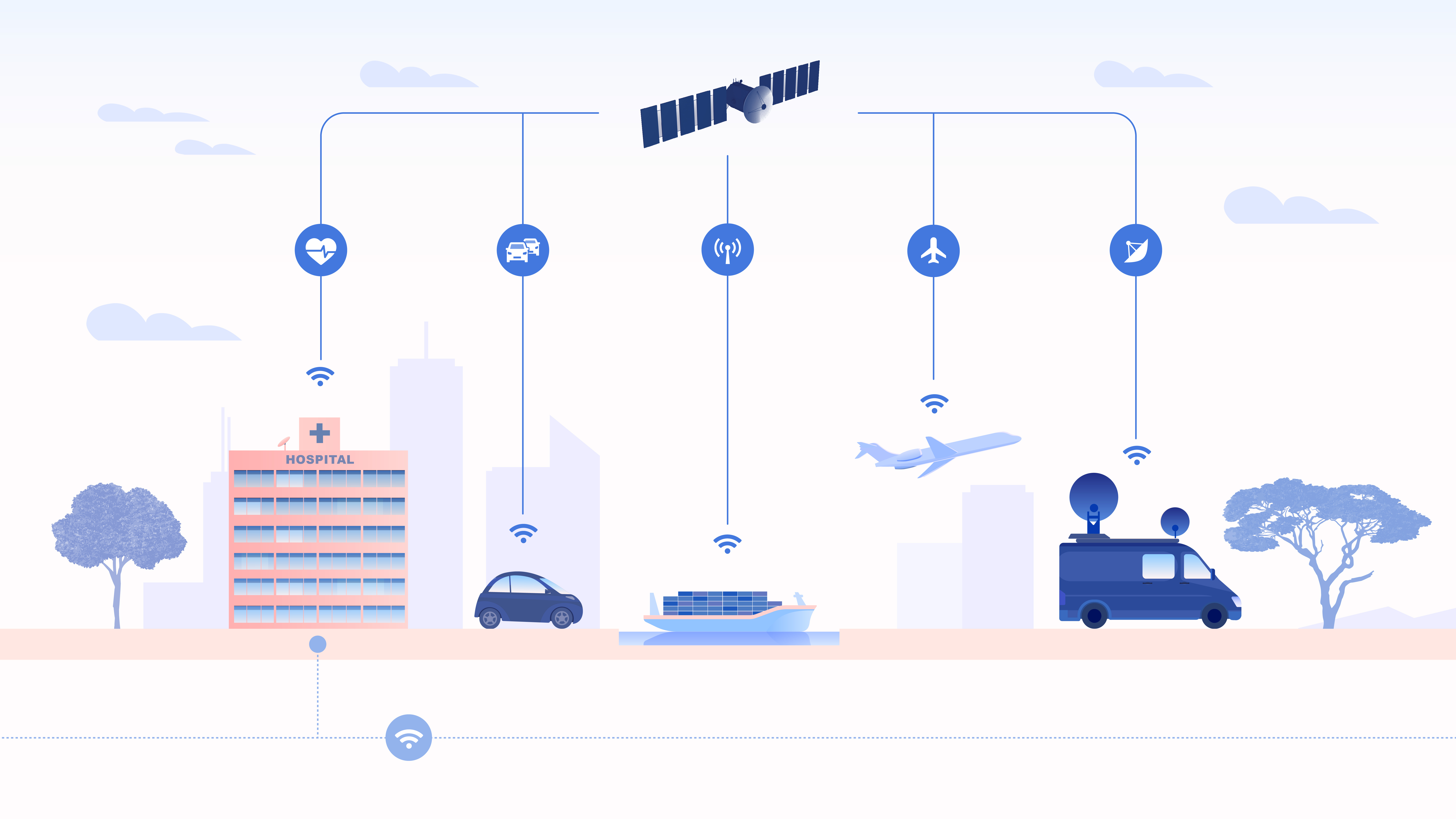
5G has arrived, and new equipment is currently being installed in densely populated cities across the globe. In many cases, the demand for 5G capacity is exceeding infrastructure improvements, especially in sparsely populated areas that are difficult to access. For years, satellite communication has remained standalone technology, independent of mobile networking. Now with the next generation of satellites – built from 5G architecture – they will integrate with networks to manage connectivity to cars, vessels, airplanes and other IoT devices in remote and rural areas.
A series of plans with broad market prospects have therefore been developed. The plans are mainly based on low-orbit micro-satellite constellations, with great advantages in terms of functional density, development cost, launch difficulty, etc.. These constellations can effectively solve the practical problem of networking in remote areas, such as oceans and deserts, and they have irreplaceable advantages in emergency communications, disaster warnings, and maritime rescue.
In the near future, 5G signals will beam down from space and support our ‘terrestrial’ 5G infrastructure on Earth. The end result is a new space race for satellites – promising to offer customers a seamless wireless experience across the entire globe.
- Low Earth Orbit (LEO) Satellites
A low earth orbit (LEO) satellite is an object, generally a piece of electronic equipment, that circles around the earth at lower altitudes than geosynchronous satellites. LEO satellites orbit between 2,000 and 200 kilometers above the earth. Demands from 5G means cheaper low earth orbit (LEO) satellites are needed to perform multiple satcomms functions. The aim for these is simple in concept: To revolutionize accessibility to space and at a low cost, and with super-fast speeds.
This question of latency is key. Some geostationary satellites at 35,786 km already provide broadband services but their transmissions take about 500-700 milliseconds (ms) to travel up and another 500-700 milliseconds to travel down. This time-lag is why viewers suffer the infuriating time delay during a conversation between the broadcast studio and an outside broadcast unit. If the OB (Outside broadcasting) is more than one satellite ‘hop’ away, then the delay is multiplied. A low Earth-orbiting craft would manage these links in about 25-30 ms, a true fraction of existing satellite links and quite comparable to existing cable or fibre networks.
The need for ubiquitous coverage for many of the proposed 5G use cases – in particular the Connected Car – has necessitated a plan to include other connectivity solutions such as Wi-Fi and satellite communications in future hybrid networks, in order to ensure that there will be no holes in the 5G coverage map.
- Low-Orbit Revolution
In the next decade, space will be an important battlefield for the development of next-generation global wireless communication technologies (B5G/6G NTN non-terrestrial network systems). In ten years, there is expected to be more than 60,000 LEO satellites flying at a speed of 7km/s to provide global wireless communication services.
Although satellites can deliver virtually blanket coverage, and potentially also the high data rates demanded for 5G, they do have a disadvantage in terms of latency. Due to the long distances involved, latency for an LEO is typically 30ms – better than the 40ms that is typically achieved by 4G LTE, but poor compared with the 5G target of less than 1ms.
Traditional communication satellites are geostationary and have been in orbit for more than 50 years. GEO satellites weigh more than 1000kg and operate 36,000 kilometers above the earth. These satellites remain in a fixed position relative to any position. Despite Earth’s orbit, this allows ground-based antennas the ability to point directly at the satellite, in a fixed position. In contrast, Low Earth Orbit (LEO) satellites are miniaturized, orbiting versions that operate between 500 and 2000 kilometers above Earth’s surface and weigh under 500kg. Due to its low orbit, latency is significantly reduced as the satellite is better positioned to quickly receive and transmit data. Unfortunately, this also creates a smaller coverage area so LEO satellites continuously hand off communication signals and traffic across a constellation of satellites. This ensures seamless, wide-scale coverage over a pre-defined geographical area.
- Private LEO Satellites
LEO satellites are the new space race. The new space race is emerging among tech companies (SpaceX, Amazon, OneWeb, etc.) to deploy LEO satellite constellations to deliver high-speed Internet service to emerging markets and business customers. Each of these companies recognizes the potential of private satellite constellations to not only provide Internet connectivity to rural areas but satisfy the global networking services of tomorrow.
Eventually, Elon Musk (Starlink) will deploy 40,000 satellites. Greg Wyler (OneWeb) will deploy 2,872 satellites, and Jeff Bezos (Project Kuiper) will deploy 3,236 satellites.
It is projected that soon we will have online more than 6 billion people, 30 billion devices and 50 billion machines. We are moving towards fully “connected world” that’s essentially everyone and everything connected, across every geography, supporting every application from consumer broadband, mobile gaming and connected cars to global business networks, ships, planes, soldiers, first responders and connected farms.
With a significantly higher data rate and very short response times compared to previous standards, 5G will tackle the current requirements for communication in a fully connected society much more comprehensively than has been possible to date. Unlike previous standards, which can be seen as general-purpose technologies to which the different services were tailored and adjusted, the next 5G standard is expected to be able to provide tailored and optimized support for a plethora of services, traffic loads, and end-user communities.
This heterogeneous and optimized framework is reflected in the challenging requirements that 5G systems are expected to meet, e.g., large throughput increase (the target peak data rate should be 20 Gbps in the downlink and 10 Gbps in the uplink), global and seamless connectivity, reliability (99.999% of successful packet reception), and connection density (1 million devices per square km), amongst others. The new 5G networking architecture promises, exponentially higher efficiencies, massive scalability, significantly lower costs for mobile and fixed networks, IoT applications, and ultra-low latency applications such as connected car and massive M2M.
In the future, 5G networks will represent the global telecommunication infrastructure of the digital economy, which should cover the whole world including inaccessible areas not covered by earlier terrestrial networks. However, there are several use cases where standard terrestrial coverage is either not present or possible, making satellite systems uniquely positioned to provide a solution to bridge this gap.
5G has the vision to become a ‘Network of Networks’ integrating multiple access technologies, including Satellite. 5G’s standardized service orchestration and the 5G NR extension for Non-Terrestrial Networks will make Satellite seamlessly integrable with the mainstream Telco ecosystem, dropping barriers for Satcom adoption.
The 5G for all – inclusive connectivity requires satellite.
› Telemedicine – making the right to healthcare a logistical reality
› Financial Inclusion – providing connectivity for banking and social programs
› National Security/Borders – giving law enforcement agencies access to broadband in the field
› Farming – precision agriculture raises incomes, creates opportunities.
› Education – extending educational opportunities to all students in a country
› SMEs – connecting businesses to global markets, enabling local e-commerce
› Disaster Recovery – resilient links, rapid deployment
New Space revolution
Recent years have also seen several advances in satellite systems and networks, allowing better efficiency, reliability, increased data rates, and new applications. New paradigms such as mega constellations are manifest, triggering significant investments in future constellations. By 2020-2025 there will be more than 100 High Throughput Satellite (HTS) systems using Geostationary (GEO) orbits but also mega-constellations of Low Earth Orbit (LEO) satellites, delivering Terabit per second (Tbps) of capacity across the world.
The future mega-constellations with 100s-10,000s of low-earth-orbit (LEO) satellites, such as Starlink [STARLINK], Kuiper [KUIPER] and OneWeb [ONEWEB] promise competitive low latency and high capacity to terrestrial networks. They expand global high-speed Internet to remote areas that were not reachable by terrestrial networks, resulting in a tens-of-billions-of-dollar market with 3.7 billion users in rural areas, developing countries, aircraft, or oceans
Satellite integration with 5G requirements
The deployment of 5G Release 15 networks by terrestrial mobile network operators (MNOs) has already begun and delivers enhanced mobile broadband (eMBB) services in small cells. The integration of satellite components, so-called Non-Terrestrial Networks (NTNs), in terrestrial infrastructure is currently studied and will be specified in Release 17. The widespread use of communication satellites in the future network-of-networks is envisaged by 2023.
3GPP Study Item for New Radio-based, i.e., 5G, Non-Terrestrial Networks aimed at deploying satellite systems either as a stand-alone solution or as integration to terrestrial networks in mobile broadband and machine-type communication scenarios. The role of NTN in 5G systems is expected to be manifold, including:
i) the support to 5G service provision in both un-served areas that cannot be covered by terrestrial 5G networks (isolated/remote areas, onboard aircraft or vessels) and underserved areas (e.g., suburban/rural areas);
ii) improve the 5G service reliability thanks to better service continuity, in particular for mission-critical communications or Machine Type Communications (MTC) and Internet of Things (IoT) devices, M2M/IoT devices or for passengers on board moving platforms; and
iii) to enable the 5G network scalability by providing efficient multicast/broadcast resources for data delivery.
Non-Terrestrial Networks and, thus, SatCom systems can bring significant benefits to future 5G services thanks to both their wide area service coverage and the significantly reduced vulnerability to physical attacks or natural disasters. Thanks to their intrinsic ubiquity and broadcasting capabilities, satellite networks can play multiple roles in 5G. The satellite can act as a main single backhaul segment for rural areas, aircrafts, vessels, trains, or as additional backhaul means to opportunistically provide additional connectivity/bandwidth resources, also improving service continuity, or as a pure transport subnetwork.
Airplanes, trains, boats and other vehicles that frequent regions of
the planet beyond the reach of cellular companies will continue to rely
on satellite links, experts agreed. In terms of system deployment, both
stand-alone 5G SatCom and integrated satellite-terrestrial solutions can
be envisaged.
Challenges
A salient feature for LEO mega-constellations is their high relative motions to the rotating earth. Unlike geosynchronous satellite or terrestrial networks, each LEO satellite moves fast ( > 25,000 km/h), causing short-lived coverage for terrestrial users (less than 3 minutes). This yields diverse challenges for the traditional network designs.
Terrestrial users access satellite networks via terminals (e.g., satellite phones, onboard dishes, IoT endpoints) or ground stations. Ground stations can serve as network gateways (e.g., carrier-grade NAT in Starlink [STARLINK-CGNAT] and Kuiper [KUIPER-CGNAT]) and remote satellite controllers (e.g., telemetry, tracking, orbital update commands, or centralized routing control).
In terrestrial and GEO satellite networks, the logical network topology, addresses, and routes are mostly stationary due to fixed infrastructure. Instead, LEO mega-constellations hardly enjoy this luxury, whose satellites move at high speeds (about 28,080 km/h). The earth’s rotation further complicates the relative motions between space and ground. For all mega-constellations, the topology changes every 10s of seconds.
In terrestrial mobile networks (e.g., 4G/5G), such physical link churn can be masked by handoffs without incurring logical topology changes. This method works based on two premises. First, all link churns occur at the last-hop radio due to user mobility, without affecting the infrastructure topology. Second, all cellular infrastructure nodes are fixed, resulting in a stable logical topology as “anchors”
However, neither premise holds in non-geosynchronous constellations. Instead, infrastructure mobility between satellites and ground stations becomes a norm rather than an exception. This voids cellular handoffs’ merits to avoid propagation of physical link churns to logical network topology: They are designed for user mobility only, and heavily rely on the fixed infrastructure as “anchors.” Therefore, 5G NTN lists satellite handoffs as an unsolved problem, and the latest 3GPP 5G release 17 defers its mobility support for satellites due to significant architectural changes. While Starlink uses handoffs to migrate physical links between satellites and ground stations (every 15s [STARLINK-CGNAT]), its logical topology and routing are still be repeatedly updated at high costs
Typical satellite channel impairments, as large path losses, delays, and Doppler shifts, pose severe challenges to the realization of a satellite-based NR network. When considering satellite communications, the Doppler shift can be caused by the satellite movement on its orbit and the user terminals’ mobility on ground.
However, current satellite systems are constrained by spectrum utilization and regulatory constraints on power flux density driven by spectrum sharing between satellite and terrestrial systems. Satellite requires very specific know-how and uses proprietary standards, making integration with mainstream network highly complex.
Enabling Technologies
Megaconstellations are enabled by recent advances in satellite miniaturization and rocket reusability.
Early satellite communications favor the simple “bent-pipe-only” model, i.e., satellites only relay terrestrial users’ radio signals to the fixed ground stations without ISLs or routing. This model has been popular in GSO satellites with broad coverage. To access the network, both terrestrial users and ground stations must reside inside the satellite’s coverage. Due to each LEO satellite’s low coverage, most users in remote areas with sparse or no ground stations cannot be served. Instead, modern LEO mega-constellations favor satellite routing to expand global coverage or enable Internet backbones. To date, inter-satellite links are still under early adoption.
As a near-term remedy, ground station-assisted routing is currently adopted. There are two variants. The GS-as-gateway is adopted by Starlink and Kuiper. Each ground station is a carrier-grade NAT that offers private IP for terrestrial users. The GS-as-relay mitigates ISLs with ground station-assisted routing, but is vulnerable to intermittent space-terrestrial links in Ku/Ka-bands. Like the “bent-pipe only” model, both heavily rely on ubiquitous ground station deployments in remote areas and even oceans, thus lowering competitive edges to terrestrial networks.
The plethora of recent advances in technologies also make it possible to merge the satellite communication systems and terrestrial networks, such as software defined networks, the Internet of things, cognitive radio, and high throughput satellites. The cost of manufacturing satellites and access to space is dramatically falling, new materials such as flexible photovoltaic and lightweight composite structures, together with virtualized network functions and software radio platforms increase capability and flexibility.
In the edge computing scenario, satellite interconnectivity may be exploited for the unicast/multicast/broadcast geographical distribution of video, audio, and application software binaries to a large number of terminals simultaneously.
As such, 5G will dramatically change how satellite is integrated into the mainstream, achieving full interoperability within the end-to-end 5G network. Adapting satellite to work seamlessly with 5G cellular and terrestrial networks will empower end users anywhere in the world with consistent, reliable, high-performance experiences. Service providers will be able to decide how they can best serve customers — whether it’s through satellite, terrestrial or mobile networks, or all of them combined.
Mobile network operators will be able to complement their 5G services with satellite connectivity to offload their terrestrial networks in a large scale. They will be able to take advantage of satellite’s inherent multicasting/broadcast functionality for new use cases, such as connected car, while preserving high-value wireless spectrum for latency-sensitive services. Or, they can use satellite’s longer range to complement the buildout of 5G in remote areas where building terrestrial networks for enhanced broadband services is simply too cost prohibitive.
In order to enable this deep integration between satellite and 5G, a number of actions should be undertaken to bring state of-the-art satellite technologies closer to the virtualization paradigm used within the 5G architecture. Many issues are related to physical layer aspects: “non-orthogonal multiple access (NOMA), massive multiple input and multiple output (MIMO), cooperative communications and network coding, full duplex (FD), device-to-device (D2D) communications, millimeter wave communications, automated network organization, cognitive radio (CR)”
The advanced communications of 5G are expected to transform three major use cases: Enhanced Mobile Broadband (eMBB), Ultra-Reliable and Low-Latency Communications (URLLC), and Massive Machine-Type Communications (mMTC). Satellite has a critical role to play in each of these categories.
Enhanced Mobile Broadband (eMBB)
According to this scenario, satellite networks are capable of maintaining data transfer at speed up to several gigabits per second, meeting the requirements for extended services of mobile broadband eMBB. Nowadays, satellite technologies can broadcast thousands of channels with the content of high bandwidth (HD and UHD). In its turn, this potential can be used to support the mobile network services of future generation. At present, satellites are being used as transport networks within 2G/3G in many regions of the world, whereas high-throughput satellites (HTS) of modern and future generations on geostationary and non-geostationary orbits can maintain transport infrastructure of mobile networks 4G/LTE and 5G in future.
With 5G comes the opportunity to offer vastly enhanced and faster
broadband connectivity (e.g., voice, video, data) to wide area networks,
hotspots for mobile or fixed networks.
• 5G to Premises: Satellite will complement terrestrial networks, such
as broadband connectivity to a home or office, in an underserved area,
or to enterprise sites as a backup.
• 5G Fixed Backhaul: Satellite will bring broadband connectivity where
it is difficult to deploy terrestrial connections in rural and remote
areas across a wide geographic region only or best covered by satellite.
• 5G Mobility Backhaul: Satellite will bring broadband connectivity to
remotes or UEs on the move, such as airplanes, trains, vehicles or
maritime vessels.
An exemplary use case of satellites in 5G is backhauling of cell traffic to connect the mobile network operators MNO core network with the edges. In current terrestrial deployments, this backhaul is based on fiber connections or microwave links. Thus, the control plane in Release 15 relies on continuous backhaul connections between the network components. However, a next-generation Node B backhauled via satellite has to handle longer signal delays as opposed to short terrestrial connections over fiber. If the gNB itself is mobile, link outages of varying duration need to be considered for the satellite backhaul link.
In the above context for worldwide 5G systems, the integration of terrestrial systems with Geostationary Earth Orbit (GEO) satellites would be beneficial for global large-capacity coverage, but the large delays in geostationary orbits pose significant challenges. However, to avoid the above issues, significant attention is being gained by Low Earth Orbit (LEO) mega-constellations, i.e., systems in which hundreds of satellites are deployed to provide global coverage, as also demonstrated.
Facebook to Amazon to SpaceX to OneWeb are in the early stages of deploying thousands of tiny, low-Earth orbit (LEO) satellites that are intended to offer much faster and cheaper satellite-based Internet services than previous offerings. For example, OneWeb reported last year that it was able to clock speeds of 400Mbit/s with latency of 32 ms from its initial batch of LEO satellites.
Ultra-Reliable and Low-Latency Communications (URLLC)
The second set of 5G use cases are URLLC applications that are particularly important for mission-critical and pseudo-real-time applications. Let’s consider the case of autonomous cars, where latency is absolutely critical. To operate successfully, autonomous cars need to be able to talk to each other and their surroundings (also referred to as ‘vehicle-to-everything’ or ‘V2X’) within milliseconds.
It is clear that satellite connectivity, regardless of its orbit (GEO, MEO, LEO), will not support certain latency sensitive applications and services, and therefore is not an optimal access technology option in V2X or autonomous driving per se; however, it will have a role in the connected car application at large, such as in passenger infotainment and car software updates.
In the case of the connected car, multicasting will allow media streaming, such as OTT and software updates, to be broadcasted to millions of cars simultaneously, vastly reducing the congestion that would otherwise be put on the base station. Satellite will complement the terrestrial buildout through traffic offloading. This would also require the endpoints (base stations or cars) to be hybrid in nature, with satellite and cellular connectivity modem technology incorporated.
Satellite communication systems gained notoriety by owing to its and their ability to meet the case concerning the requirements for network signal delays, aiming at procuring critical and highly reliable communications. The principal users of these networks are international broadcasters, mobile network operators, governmental bodies, and commercial users. The applications that turn out to be more sensitive to signal delays can be bolstered via new medium and low earth orbit satellite networks, which will to be deployed.
Massive Machine-Type Communications (mMTC)
The third set of use cases are mMTC for M2M or IoT devices and sensors. SDN functionality will play a critical role here as it allows for a given UE to be serviced with far fewer resources, in return enabling several UEs to be serviced with the equivalent resource of a single 4G UE. This already showcases the promised scale that comes with 5G.
The 5G architecture needs to dramatically scale as it will be
connecting and backhauling data from millions of smart devices and
sensors inside homes and urban infrastructure, as they will become
prevalent in smart cities of the future. While small in nature, the
sheer aggregated volume of this M2M and IoT connectivity will have a
major impact on the network load. In order to offload 5G networks, one
opportunity for satellite can be backhauling non-latency sensitive data
from these devices, or more precisely, from the aggregation points
back to the core network.
Satellite communication systems are already keeping up the technology of SCADA and other global applications for cargo and object tracking in the context of IoT devices mass use. Their capabilities can be scaled up to support devices and services of IoT within the direct control channel or as a feedback line with IoT and M2M devices from remote locations, ships, and other carrying vessels.
5G Satellite projects
In addition to the 3GPP standardisation effort, funded projects are currently addressing SatCom-based 5G systems, as, for instance:
i) the EC H2020 project VITAL (VIrtualized hybrid satellite-Terrestrial systems for resilient and fLexible future networks), in which the combination of terrestrial and satellite networks is addressed by bringing Network Functions Virtualization (NFV) into the satellite domain and by enabling Software-Defined-Networking (SDN)-based, federated resources management in hybrid SatCom-terrestrial networks,;
ii) the EC H2020 project Sat5G (Satellite and Terrestrial Network for 5G), which aims at developing a cost-effective SatCom solution by means of satellite gateway and terminal virtualisation and use cases demonstration;
iii) the ESA project SATis5 (Demonstrator for Satellite Terrestrial Integration in the 5G Context), in which a set of relevant satellite use cases for 5G in the areas of enhanced Mobile BroadBand (eMBB) and massive IoT deployments will be demonstrated,; and
iv) the H2020 project SANSA (Shared Access Terrestrial-Satellite Backhaul Network enabled by Smart Antennas), aimed at to enhancing the performance of mobile wireless backhaul networks, both in terms of capacity and resilience, while assuring an efficient use of the spectrum,
The call for proposals is part of a joint effort by the UK Space Agency, the European Space Agency (ESA) and the Department for Digital, Culture, Media & Sport (DCMS), with hopes of increasing connectivity and closing the digital divide for businesses in the sector. “Access to constant connectivity regardless of location offers huge benefits,” said Catherine Mealing-Jones, director of growth at the UK Space Agency. “We’ve seen through the current pandemic, that logistics are vital to keeping the country going and space technology is a key part of making that happen.”
Magali Vaissiere, ESA director of telecommunications and integrated applications added: “This is a great opportunity for ESA to join forces with DCMS and UK Space Agency and prove the key role that satellite communications will play in the future converged 5G networks. “In the context of the ESA 5G Strategic Programme Line, this Call for Proposals is intended to stimulate the emergence of sustainable applications relying on innovative 5G solutions, starting from the logistics sector.”
Boeing presented NGSO system
The Boeing company requested the US Federal Communications Commission for permission to launch and operate fixed satellite service (FSS) network on non-geostationary orbit (NGSO). The network would operate in a low-Earth orbit (LEO) in the frequency band 37.5–42.5 GHz (space-Earth) and in the frequency bands 47.2–50.2 and 50.4–52.4 GHz of V-band (Earth-space); it would be used as a NGSO system providing solution of 5G satellite segment operation issues.
The Boeing proposed NGSO system considered as a 5G satellite segment that is designed to provide a wide range of modern telecommunication services alongside with 5G internet services for a broad types of V-band earth stations and user terminals. V-band user terminals use modern antenna arrays for transmitting and receiving broadband signals in channels of different pass bands. It is to note that a high throughput is supported by multichannel and multiple polarization terminals.
The Boeing presented NGSO system would consist of 2956 LEO satellites for the fixed satellite service network providing high throughput low latency access for user terminals connected through gateway (“hubs”) access to 5G network and to a terrestrial optic-fiber network as backhaul connecting to 5G. The system gateways are expected to be located outside the densely populated areas in the regions with relatively low consumer demand for 5G services. Each NGSO satellite would form beams, corresponding to cell diameter from 8 up to 11 km on the Earth surface within the overall satellite coverage area.
The NGSO system gateways would operate in the same V-band as user terminals. These gateways would support both frequency and polarization selection of signals with two types of antennas polarization LHCP (Left Hand Circular Polarized) and RHCP (Right Hand Circular Polarized). In addition, the access gateways may contain more than one antenna thereby providing simultaneous access to multiple NGSO satellites visible from a relevant access gateway. At the first stage of deployment, the Boeing NGSO system would comprise a constellation of 1396 LEO satellites in an altitude of 1200 km. The initial satellite constellation would consist of 35 circular orbital planes with an inclination of 45° and additional 6 circular planes inclined at 55°.
The NGSO system payload would use the improved space-time processing in the course of antenna beam-forming as well as on board digital processing so as to generate thousands of narrow-band beams to provide 5G network services through satellite segment on the Earth surface.
Each satellite up-link or down-link may consist of up to five channels of 1 GHz pass band resulting in a total pass band of 5 GHz depending on instant capacity required for a cell supported by a relevant satellite antenna beam. Any satellite UL-channel may be connected to any satellite DL-channel in compliance with used connection algorithm. Boeing company estimation results show that usage of a satellite network for fixed satellite channels and its spectrum sharing with a 5G terrestrial network in the frequency band 37.5–40.0 GHz would be feasible under the following conditions:
- the frequency band 37.5–40.0 GHz is used only for signal reception in FSS network downlink;
- spectrum sharing between 5G satellite segment and 5G terrestrial segment is feasible due to high satellite elevation angles;
- applying of space-time selection beam-forming methods for terminal antennas of satellite networks and 5G equipment in the aim to achieve higher data rate.
The power flux density (PFD) limits approved by ITU would provide protection for 5G network terrestrial segment from interference caused by FSS satellite network downlinks subject to meeting the requirement of minimal reducing of 5G terrestrial network signal level to 0.2–0.6 dBW.
As confirmation, possibility of successfully utilization integrated satellite segment into 3GPP 5G testbed networks was the last demonstration of Surrey University achievements in 5G satellite network development. Three use cases were demonstrated over a live satellite network via Avanti’s GEO HYLAS 4 satellite and using iDirect’s 5G-enabled Intelligent Gateway (IGW) satellite ground infrastructure that to 5G testbed core network of the University of Surrey to 5G UE terminals. All the 5G testbed use cases used this integrated 5G satellite system for the live satellite connectivity. The use-case for 5G moving platform was demonstrated over SES’s O3b MEO satellite system, using real terminals and 5G core network.
From the networking viewpoint, network virtualization is a concept
that will bring benefits in terms of lower costs, higher flexibility,
and tailored service provision. The adoption of SDN and NFV technologies
into the satellite domain is seen as a key element to accomplish
satellite and mobile terrestrial networks integration, allowing the
creation of a heterogeneous 5G network architecture and the provision of
dedicated slices. In this vision, satellite network architectures
should be augmented with autonomous and flexible management of service
lifecycle operations, including the real-time monitoring of performance
and other 5G KPIs. The integration of terrestrial and satellite networks
in 5G through the virtualization of network functions, the provision of
slices, and the use of general-purpose instead of ad-hoc hardware, will
not be immediate. Moreover, the investments required to design and
deploy a GEO/LEO satellite communication network are huge, so current
satellite operators cannot replace costly hardware components before the
end of the
scheduled network lifetime, especially concerning on-board technologies.
One of the most important issues of 5G satellite segment future development may refer to shared spectrum usage in the frequency bands allocated to 5G satellite and terrestrial segments on the primary basis. Also urgent is the issue of intersystem electromagnetic compatibility of aboard equipment and earth stations with base stations and user devices of 5G terrestrial segment.
Omnispace tests initial 5G-via-satellite capability for US Navy and USMC, reported in March 2021
Omnispace has successfully demonstrated an initial 5G-via-satellite capability for the US Navy and US Marine Corps (USMC). The capability was tested in a LinQuest lab demonstration. Omnispace’s technology is being piloted in associated with Verizon’s new 5G Living Lab. The National Security Innovation Network (NSIN) selected the company last year to showcase its 5G non-terrestrial network (NTN) connectivity solutions for use by the US government and military. Omnispace Government and International Markets vice-president Campbell Marshall said: “Omnispace is honoured to have been selected to work with the US Navy and Marines to demonstrate 5G capability from space.
“The development of standards-based 5G non-terrestrial network (NTN) technology powered by Omnispace’s S-band spectrum will allow small tactical 5G devices to communicate directly and seamlessly with 5G-capable satellites and terrestrial networks, giving our warfighters ubiquitous global connectivity and true comms-on-the-move.” During the trials, LinQuest’s lab facility in Northern Virginia and several commercial-off-the-shelf 5G devices were used. Through an emulated 5G radio access network (RAN), the devices were able to communicate voice and data services to Omnispace’s on-orbit satellite. Marine Corps lieutenant colonel Brandon Newell said: “5G will be a critical technology for our military operations in the very near future, and those operations aren’t limited to dense urban environments where most 5G infrastructure is being deployed.
Verizon 5G and Amazon Project Kuiper collaboration
Strategic collaboration aims to pair Verizon’s terrestrial mobile network with Amazon’s low Earth orbit (LEO) satellite network, Project Kuiper. Project Kuiper to deliver cellular backhaul solutions to extend Verizon’s 4G/LTE and 5G data networks, connecting rural and remote communities in the U.S.
Verizon and Project Kuiper to explore joint connectivity solutions for domestic and global enterprises across agriculture, energy, manufacturing, education, emergency response, transportation and other industries.
To begin, Amazon and Verizon will focus on expanding Verizon data networks using cellular backhaul solutions from Project Kuiper. The integration will leverage antenna development already in progress from the Project Kuiper team, and both engineering teams are now working together to define technical requirements to help extend fixed wireless coverage to rural and remote communities across the United States.
he Kuiper System is designed with the flexibility and capacity to support enterprises of all sizes. By pairing those capabilities with Verizon’s wireless, private networking and edge compute solutions, the two will be able to extend connectivity to businesses operating and deploying assets on a global scale.
Market
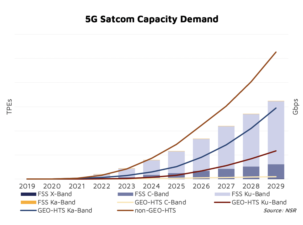
NSR’s 5G via Satellite: Impacts, Demand and Revenue Potential report forecasts that 1 in every 4 USD in FSS Satellite Capacity Revenues for Data verticals will be generated from 5G traffic by 2029.
The Satellite IoT segment will undoubtedly witness significant benefits from 5G. In a segment where remotes often send just a few Kbs from time to time, bandwidth is not the main driver in the TCO. On the other hand, terminal cost can make or break the business case. Satellite today uses proprietary systems with limited scale driving terminal cost in the order of ~$100. However, adopting the 5G NR waveform would open access to mainstream chipsets and devices, dropping terminal cost to ~$10s. If that is not enough, instead of using specialized resellers, Satellite IoT would gain access to mainstream sales channels and a massive addressable market skyrocketing adoption for Satellite services.
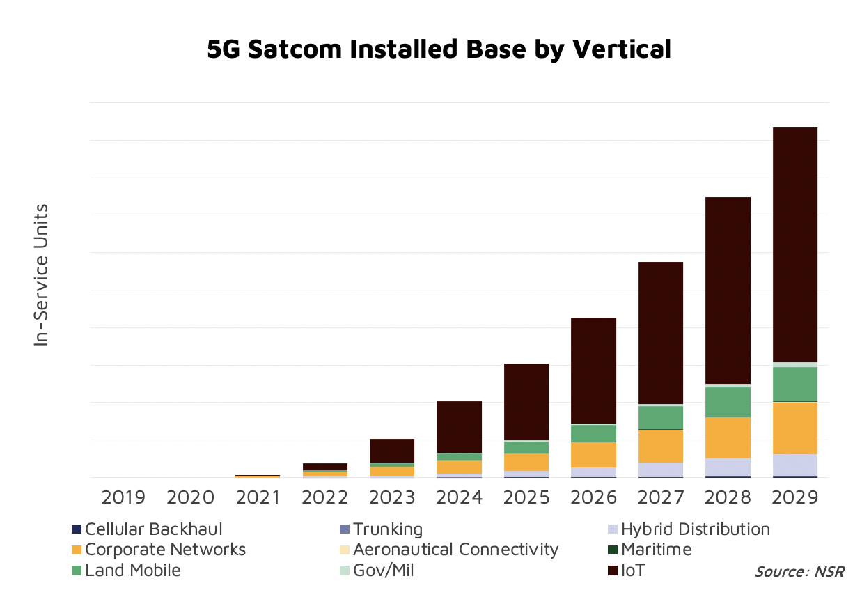
MNOs have made it very clear that Enterprise Services are one of their key focus to drive 5G incremental revenues. 5G networking tools are very powerful allowing for network slicing to route traffic optimally depending on the application requirements. If Satellite is able to integrate in the 5G ecosystem, there will be numerous opportunities emerging from the unique set of attributes that a Satellite overlay can introduce to terrestrial networks (security, redundancy, broadcasting, etc.).
5G is a unique opportunity for Satellite to become a mainstream technology. But to realize this potential, the industry must ensure that it can meet 5G standards both at the network orchestration level and at the radio access level (for narrowband applications like IoT). This would drop historical barriers for Satcom such as integration complexities or high TCOs.
Network attributes highly valued by both Enterprise and customers match very well what Satellite can offer to the ecosystem (enhanced levels of security, coverage, etc.). Network attributes such as slicing or ubiquity ensure a prolific future for satellites in the 5G ecosystem.
References and resources also include:
https://spacenews.com/what-the-satellite-industry-needs-to-know-about-where-5g-stands/
https://arxiv.org/pdf/1806.02088.pdf
https://www.intechopen.com/online-first/prospects-of-5g-satellite-networks-development
https://www.nsr.com/research/5g-via-satellite-impacts-demand-revenue-potential-to-2029/
https://www.ietf.org/id/draft-li-istn-addressing-requirement-00.html