U.S. Marines Deploy Radar on Japanese Island Near Taiwan - USNI News
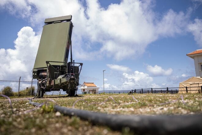
As part of the ongoing U.S. Marine Corps-Japan Self-Defense Force bilateral exercise Resolute Dragon 24, the 12th Marine Littoral Regiment deployed an AN/TPS-80 Ground/Air Task Oriented Radar (TPS-80) system on Thursday to Yonaguni Island.
The Japanese island near Taiwan has been often passed by Chinese military ships, aircraft and Unmanned Aerial Vehicles transit near it. Meanwhile, on Saturday, a Chinese Y-9 electronic intelligence aircraft and two UAVs presumed to belong to China carried out surveillance missions west of Taiwan and transited around Japan’s southwest islands, passing near Yonaguni Island.
A Marine Corps release on Sunday stated the radar was transported to Yonaguni Island by a Japan Air Self Defense Force C-2 transport aircraft and marked the first time that the radar was deployed to the island. The TPS-80 is a multi-mission system designed to provide advanced air surveillance, ground surveillance, and weapon control capabilities from a single, mobile platform.
“During Resolute Dragon 24, the TPS-80 will be utilized by 12th MLR and the JSDF to enhance situational awareness by supporting comprehensive detection and tracking across air, land, and maritime domains,” said Lt. Col Joseph Mozzi, the fire support coordinator for 12th MLR, in the release. “This will significantly boost multi-domain operations and overall battlespace awareness throughout the exercise.”
This is the first time 12th MLR has participated in a Resolute Dragon exercise since its redesignation in November 2023. Resolute Dragon 24 is an annual bilateral exercise in Japan between the III Marine Expeditionary Force (MEF) and all three services of the Japan Self Defense Force. The focus of the exercise series is on controlling and defending key maritime terrain. This year’s iteration runs from Jul. 28 to Aug. 7.
Yonaguni Island lies 68 miles east of Taiwan has been identified as a key area in Japan’s planning for the defense of its southwest islands and the disputed Senkaku Islands held by Japan but claimed by China. PLAN ships routinely pass by the island when conducting transits between the East China Sea and the Philippine Sea, particularly when conducting operations off the western side of Taiwan to demonstrate China could carry out a complete blockade of Taiwan anytime. Similarly, Chinese military aircraft and UAVs also pass near Japan’s southwest islands while carrying our reconnaissance and surveillance missions off the west side of Taiwan.
Japan already has a radar site and an electronic warfare unit on Yonaguni, as well as plans to station surface-to-surface missiles on the island and other islands in the southwest region. The U.S. and Japan also have agreed to increase bilateral presence in Japan’s southwest islands as part of the U.S.-Japan alliance.
On Saturday, Japan’s Joint Staff Office issued a release stating that on Saturday afternoon, a Chinese Y-9 flew in from the East China Sea and subsequently passed by between Miyako Island and Okinawa to enter the Philippine Sea, and then flew over it until it was off Yonaguni Island. It flew in a circuit there before returning the same way to the East China Sea. A flightpath map included in the release showed the Y-9’s circuit taking place in an area south of Yonaguni Island and west of Taiwan.
A presumed Chinese UAV also flew in the afternoon from the East China Sea, passing between Yonaguni Island and Taiwan to reach the Philippine Sea, and then conducted a circuit in an area west of Taiwan before subsequently flying towards the Bashi Channel, which lies between the Philippines’ Mavulis Island and Taiwan’s Orchid Island, according to the release. The Bashi Channel also is a common transit route for PLAN ships moving between the South China Sea and Philippine Sea.
The release also stated that a second presumed Chinese UAV flew in from the Philippine Sea in the afternoon and passed through between Yonaguni Island and Taiwan to enter the East China Sea. In response, fighters from the JASDF Southwest Air District were scrambled, stated the release.
Related

Chinese, Russian Warships Sail Around Japanese Islands
Several Chinese and Russian ships and a Chinese unmanned aerial vehicle operated around Japan on Sunday and Monday, according to the Japanese Joint Staff Office. People's Liberation Army Navy destroyer CNS Kaifeng (124) and frigate CNS Yantai (538) were sighted sailing northwest 31 miles south of Yonaguni Island and then…


No comments:
Post a Comment