Summary of Satellite Constellation Modeling & Simulation
Methods:
- - Use orbital propagation models to simulate satellite positions over time
- - Implement perturbation models to account for effects like atmospheric drag, Earth's oblateness (J2), solar radiation pressure, etc.
- - Model satellite operations like station-keeping, deployment, and end-of-life maneuvers
- - Perform all-on-all conjunction detection to identify potential collisions
- - Use deterministic and/or stochastic methods for conjunction detection
- - Model inter-satellite links and ground-to-satellite communications
- - Implement routing algorithms like Dijkstra's shortest path to determine communication paths
Inputs:
- - Initial orbital parameters for satellites (Keplerian elements)
- - Constellation design parameters (number of planes, satellites per plane, altitude, inclination, etc.)
- - Satellite physical properties (size, mass, drag coefficient, etc.)
- - Operational parameters (station-keeping thresholds, maneuver capabilities)
- - Environmental models (atmosphere, gravity field, etc.)
Outputs:
- - Satellite positions and velocities over time
- - Collision/conjunction events and statistics
- - Communication network topology and routing
- - Latency/round-trip time between ground stations
- - Coverage statistics
Key aspects:
- - Use simplified models and large time steps (hours) to enable long-term simulations of large constellations
- - Validate models against real satellite data (e.g. TLE data)
- - Balance computational efficiency with fidelity
- - Model both individual satellites and full constellation dynamics
- - Incorporate realistic operational procedures like deployment and station-keeping
Methods and tools for simulating large satellite constellations
1. Orbital Propagation Tools:
- High-fidelity orbital propagation
- Comprehensive suite of analysis tools
- Industry standard with wide acceptance
Costs:
- Expensive licensing fees
- Steep learning curve
Weaknesses:
- Can be computationally intensive for large constellations
- Limited customization for specialized analyses
- Open-source and free
- High accuracy for interplanetary missions
Costs:
- Time investment to learn the tool
Weaknesses:
- Less user-friendly than commercial alternatives
- Limited built-in support for large constellation analysis
2. Conjunction Detection Methods:
- Provides exact conjunction times and locations
- Suitable for detailed analysis of specific events
Costs:
- Computationally expensive, especially for large constellations
Weaknesses:
- May be unnecessarily precise for long-term statistical studies
- Computationally efficient for large constellations
- Good for long-term statistical analysis
Costs:
- Less precise than deterministic methods
Weaknesses:
- Does not provide exact conjunction details
- May over or underestimate conjunction rates in some cases
3. Network Simulation Tools:
- Open-source and extensible
- Good for detailed communication protocol simulation
Costs:
- Time to develop custom modules for satellite networks
Weaknesses:
- Scalability challenges for very large constellations
- Limited built-in support for orbital dynamics
- Open-source with active community
- Flexible and extensible
Costs:
- Steep learning curve
Weaknesses:
- Limited built-in support for satellite-specific features
- Can be complex to set up large-scale simulations
c) Custom Simulation Frameworks:
- Can be tailored to specific research questions
- Potential for high performance with optimized code
Costs:
- Significant development time
- Ongoing maintenance and updates required
Weaknesses:
- Lack of standardization can make results harder to compare
- Potential for bugs or inconsistencies if not rigorously tested
4. Routing Algorithms:
- Simple to implement
- Guarantees optimal paths
Costs:
- Can be computationally expensive for large networks
Weaknesses:
- Does not account for dynamic network changes without recomputation
b) Adaptive Routing Protocols:
- More realistic representation of operational systems
Costs:
- More complex to implement and analyze
Weaknesses:
- May not always find optimal paths
- Can introduce additional overhead in the network
5. Perturbation Models:
- Highly accurate for short-term predictions
- Accounts for complex physical phenomena
Costs:
- Computationally expensive
- Requires frequent updates of input data (e.g. solar flux)
Weaknesses:
- May be overkill for long-term statistical studies
b) Simplified Analytical Models:
- Computationally efficient
- Suitable for long-term studies
Costs:
- Reduced accuracy compared to high-fidelity models
Weaknesses:
- May miss important effects in some scenarios
In choosing methods and tools for constellation simulation, researchers and engineers must balance computational efficiency, accuracy, ease of use, and the specific requirements of their study. Often, a combination of tools and methods is used, with high-fidelity tools for detailed analysis of specific scenarios and more simplified models for long-term statistical studies of large constellations.
Space Weather and Earth Ionosphere
1. Space Weather and Coronal Mass Ejections (CMEs):
- NOAA's Space Weather Prediction Center (SWPC) models
- NASA's CCMC (Community Coordinated Modeling Center) models
Impacts considered:
- Atmospheric density changes affecting drag
- Solar radiation pressure variations
- Potential damage to satellite electronics
Simulation approaches:
- Incorporation of solar flux (F10.7 index) predictions
- Use of geomagnetic indices (Kp, Ap) in atmospheric models
- Monte Carlo simulations to account for space weather uncertainties
Example: Sascha Schäfer et al. (2019) "Impact of space weather on satellite operations and the impact on LEO satellite constellations" in Advances in Space Research.
2. Earth's Magnetic Field Variation:
- International Geomagnetic Reference Field (IGRF)
- World Magnetic Model (WMM)
Impacts considered:
- Changes in satellite attitude control requirements
- Variations in trapped radiation environments
Simulation approaches:
- Periodic updates of magnetic field models in orbit propagators
- Long-term simulations to capture secular variations
3. Ionosphere Perturbations:
- International Reference Ionosphere (IRI)
- NeQuick model
Impacts considered:
- Signal propagation effects (important for communication and navigation)
- Increased drag at lower LEO altitudes during high solar activity
Simulation approaches:
- Incorporation of ionospheric models in link budget calculations
- Modeling of scintillation effects on signal quality
Example: Yavuz et al. (2021) "Ionospheric and atmospheric effects on LEO satellite signals" in GPS Solutions.
4. Gamma-Ray Bursts (GRBs):
Impacts considered:
- Potential for single-event upsets in satellite electronics
- Ionospheric disturbances affecting radio propagation
Simulation approaches:
- Worst-case scenario modeling for satellite shielding design
- Incorporation into overall radiation environment models
5. Integrated Approaches:
- ESA's Space Environment Information System (SPENVIS)
- NASA's NAIRAS (Nowcast of Atmospheric Ionizing Radiation for Aviation Safety)
These tools allow for more comprehensive modeling of the space environment's impact on satellite constellations.
6. Machine Learning and AI:
- Predict short-term space weather impacts on satellite operations
- Optimize constellation management in response to space weather events
Example: Camporeale (2019) "The Challenge of Machine Learning in Space Weather: Nowcasting and Forecasting" in Space Weather.
Challenges in incorporating space weather effects:
- Variability: Space weather can be highly variable and difficult to predict accurately over long periods.
- Complexity: The interactions between different space weather phenomena are complex and not fully understood.
- Computational intensity: Incorporating detailed space weather models can significantly increase simulation complexity and run time.
- Data limitations: Long-term historical data for some phenomena is limited, making it difficult to model rare but extreme events.
- Uncertainty propagation: Space weather uncertainties can compound other uncertainties in constellation simulations.
Importance for LEO constellations:
- Lifetime predictions: Accurate modeling of atmospheric drag variations due to space weather is crucial for predicting satellite lifetimes and planning replacements.
- Collision avoidance: Space weather can affect orbit predictions, impacting collision avoidance strategies.
- Communication reliability: Ionospheric effects can impact signal propagation, affecting constellation performance.
- Power management: Solar activity variations affect power generation and thermal management.
- Risk assessment: Understanding the potential impacts of extreme space weather events is crucial for overall constellation risk management.
Optimizing Constellation Costs
1. Launch costs:
- Number of satellites per launch vehicle
- Launch sequence and deployment strategy
- Trade-offs between different launch providers and vehicles
Simulation allows testing different scenarios to minimize overall launch costs while meeting constellation deployment timelines.
2. Satellite costs over time:
- Economies of scale in satellite production
- Learning curve effects as more satellites are built
- Technology improvements over time leading to cost reductions
This helps forecast total satellite production costs over the constellation's lifetime.
3. Orbital lifetime:
- Atmospheric drag effects at different altitudes
- Solar cycle impacts on atmospheric density
- Collision avoidance maneuver frequency and propellant usage
These factors affect satellite lifetime and replacement rates.
4. Replacement strategies:
- Preventive vs. reactive replacement policies
- Spare satellite deployment strategies
- End-of-life deorbit procedures
This helps minimize service interruptions while managing costs.
5. Overall constellation economics:
- Total lifecycle costs
- Revenue projections based on coverage and capacity
- Return on investment under different scenarios
Simulation tools that can assist with these analyses include:
- STK (Systems Tool Kit): Can model constellation deployment, coverage, and lifetime. Includes some economic analysis capabilities
- Analytical Graphics Inc. (AGI) Constellation Design Tool: Specializes in optimizing constellation designs and analyzing costs
- Custom simulation frameworks: Often built in Python, MATLAB, or similar environments. Can be tailored to specific constellation architectures and business models
- Monte Carlo simulation tools: Used to account for uncertainties in costs, lifetimes, and market conditions
- SPENVIS (Space Environment Information System): Helps model environmental effects on satellite lifetime
- - Accuracy depends on input data quality (e.g. cost estimates, market projections)
- - May not capture all real-world complexities (e.g. regulatory changes, geopolitical factors)
- - Requires regular updates as technology and market conditions evolve
Overall, while simulations can't predict exact costs with certainty, they are invaluable tools for comparing different constellation architectures, identifying key cost drivers, and optimizing deployment and replacement strategies. They allow operators to make more informed decisions about constellation design and management, potentially saving billions of dollars over the life of a project.
Predicting Orbital Lifetime
1. NASA Debris Assessment Software (DAS):
- Free and publicly available
- Includes atmospheric models for drag calculation
- Can account for solar activity predictions
Limitations:
- Simplified drag models
- Limited to altitudes below 2000 km
2. ESA's DRAMA (Debris Risk Assessment and Mitigation Analysis):
- Includes detailed atmospheric models
- Can model complex satellite geometries
- Provides orbit evolution and re-entry predictions
Limitations:
- Requires ESA authorization for full access
3. ODTK (Orbit Determination Tool Kit):
- High-fidelity orbit propagation
- Can incorporate detailed satellite models
- Allows for parameter estimation to improve predictions
Limitations:
- Commercial software with associated costs
- Steep learning curve
4. GMAT (General Mission Analysis Tool):
- Open-source and highly customizable
- Can model complex force models including atmospheric drag
- Supports scripting for automation of analyses
Limitations:
- May require significant setup time for complex scenarios
- Less user-friendly than some commercial alternatives
5. Semi-analytical Lifetime Prediction Tools:
Strengths:
- Fast computation times
- Good for long-term predictions and sensitivity analyses
Limitations:
- Less accurate for highly eccentric orbits or very low altitudes
6. SESAM (Spacecraft Early System Analysis Model):
- Focuses on satellite reliability and MTBF
- Includes component-level reliability modeling
- Can be used for trade-off analyses in early design phases
Limitations:
- More focused on reliability than orbital dynamics
7. SPENVIS (Space Environment Information System):
- Provides detailed space environment models
- Includes tools for radiation analysis, which can affect MTBF
- Free for registered users
Limitations:
- More focused on environmental effects than detailed orbit propagation
8. Custom Python/MATLAB scripts:
- Highly customizable
- Can integrate multiple models (drag, MTBF, etc.)
- Useful for specific constellation designs
Limitations:
- Requires significant development and validation effort
- May lack some advanced features of specialized tools
Key factors these tools consider:
1. Atmospheric drag:
- Atmospheric density models (e.g. NRLMSISE-00, JB2008)
- Solar and geomagnetic activity predictions
- Satellite cross-sectional area and drag coefficient
2. Satellite shape and attitude:
- Detailed geometric models for accurate drag calculation
- Attitude control strategies (e.g. feathering to minimize drag)
3. MTBF and reliability:
- Component-level reliability data
- Redundancy configurations
- Environmental stress factors (radiation, thermal cycling, etc.)
4. Orbital parameters:
- Initial orbit (altitude, eccentricity, inclination)
- Perturbations (J2, solar radiation pressure, third-body effects)
5. Operational factors:
- Planned maneuvers
- Station-keeping strategy
- End-of-life disposal plans
When using these tools, it's important to:
- Use the most up-to-date atmospheric models and solar activity predictions
- Accurately model the satellite's physical characteristics and operational profile
- Consider uncertainties and perform sensitivity analyses
- Validate predictions against real-world data when possible
By combining these specialized tools with broader constellation simulation frameworks, operators can make more accurate predictions about satellite lifetimes, optimize orbital parameters and spacecraft design, and develop effective replenishment strategies for maintaining constellation performance over time.
Orbital maneuvering for collision avoidance
1. Collision Avoidance Simulations:
Tools and Methods:
- NASA's CARA (Conjunction Assessment Risk Analysis) system
- ESA's DRAMA (Debris Risk Assessment and Mitigation Analysis)
- AGI's STK (Systems Tool Kit) with COLA (Collision Avoidance) module
- Custom simulation frameworks using languages like Python or MATLAB
Key Features:
- Conjunction detection algorithms
- Probability of collision calculations
- Maneuver optimization
Simulation Aspects:
- Long-term propagation of satellite and debris orbits
- Monte Carlo simulations to account for uncertainties
- Evaluation of different collision avoidance strategies
Challenges:
- Balancing collision risk with operational impact and fuel consumption
- Dealing with incomplete or uncertain data about debris objects
- Coordinating maneuvers in large constellations
2. Kessler Effect Simulations:
Tools and Methods:
- NASA's LEGEND (LEO-to-GEO Environment Debris model)
- ESA's MASTER (Meteoroid and Space Debris Terrestrial Environment Reference)
- DAMAGE (Debris Analysis and Monitoring Architecture to the Geosynchronous Environment)
Key Features:
- Long-term debris environment evolution modeling
- Impact of different mitigation strategies
Simulation Aspects:
- Modeling of debris creation from collisions and explosions
- Propagation of debris populations over decades or centuries
- Evaluation of active debris removal strategies
Challenges:
- Accurately modeling fragmentation events
- Accounting for future launch activities and constellation deployments
- Balancing computational complexity with simulation timescales
3. Integrated Constellation Management Simulations:
These combine collision avoidance, Kessler effect mitigation, and overall constellation management.
Key Aspects:
- Optimizing constellation design for collision avoidance
- Evaluating end-of-life disposal strategies
- Assessing the impact of constellation operations on the overall space environment
Simulation Considerations:
- Fuel budgeting for collision avoidance maneuvers
- Trade-offs between constellation performance and space sustainability
- Coordination of maneuvers across the entire constellation
4. Machine Learning and AI Integration:
Emerging approaches use AI to:
- Predict high-risk conjunctions
- Optimize collision avoidance maneuvers
- Develop adaptive strategies for long-term space environment management
5. International Coordination Simulations:
These model the effects of different space traffic management policies and international agreements.
Key Aspects:
- Evaluating proposed guidelines for responsible space operations
- Assessing the impact of improved space situational awareness capabilities
- Modeling the effectiveness of coordinated collision avoidance procedures
Challenges in Collision Avoidance and Kessler Effect Simulations:
1. Data quality: Accurate simulations require precise orbital data for all objects, which is not always available.
2. Computational complexity: Simulating large numbers of objects over long time periods is computationally intensive.
3. Uncertainty propagation: Small errors in initial conditions can lead to large uncertainties over time.
4. Human factors: Modeling decision-making processes of satellite operators adds complexity.
5. Future scenario modeling: Predicting future launch activities and technology developments is challenging.
6. Validation: It's difficult to validate long-term predictions about the space environment.
Benefits of These Simulations:
1. Risk assessment: Quantify collision risks and long-term debris growth.
2. Strategy optimization: Develop and test collision avoidance and debris mitigation strategies.
3. Policy support: Provide data to inform space policy and regulations.
4. Constellation design: Optimize constellation architectures for long-term sustainability.
5. Resource planning: Estimate fuel requirements and operational costs for collision avoidance.
6. Environmental impact assessment: Evaluate the long-term effects of constellation deployments on the space environment.
By incorporating these simulations into the design and operation of satellite constellations, operators can develop more sustainable practices, minimize collision risks, and help mitigate the potential for cascading debris generation (Kessler syndrome). This is increasingly important as the number of satellites in orbit continues to grow rapidly.
Examples of Use
1. SpaceX Starlink:
- - Hugh Lewis (University of Southampton) used the DAMAGE model to simulate the long-term impact of Starlink on the space environment.
- - Results suggested Starlink satellites could be involved in up to 90% of all close encounters between satellites at certain altitudes.
- - SpaceX has used these and other simulations to adjust their constellation design, including lowering the operational altitude of some satellites to reduce orbital lifetime.
2. OneWeb:
- - ESA conducted simulations using their DRAMA tool to assess collision risks and de-orbiting strategies for the OneWeb constellation.
- - These simulations helped inform OneWeb's de-orbiting plans and collision avoidance procedures.
3. Amazon Kuiper:
- - Amazon has reported using custom simulation tools to optimize their constellation design for coverage while minimizing collision risks.
- - They've used these simulations to justify their chosen orbital altitudes and inclinations to the FCC.
4. ESA's Collision Risk Estimation and Automated Mitigation (CREAM) project:
- - While not focused on a specific constellation, this project uses simulations of multiple constellations to develop automated collision avoidance systems.
- - It includes simulations of future LEO environments with multiple mega-constellations deployed.
5. NASA Conjunction Assessment studies:
- - NASA has conducted extensive simulations of conjunction events in a future LEO environment populated by multiple large constellations.
- - These studies have informed discussions about space traffic management and the need for improved space situational awareness.
6. Iridium NEXT:
- - Iridium used detailed simulations to plan the replacement of their original constellation with Iridium NEXT.
- - This included modeling collision risks during the transition period when both old and new satellites were operational.
7. Planet Labs:
- - Planet has used simulations to optimize the deployment and management of their large constellation of Earth observation satellites.
- - This includes modeling collision risks and planning for constellation replenishment.
8. Telesat Lightspeed:
- - Telesat has reported using advanced simulations to optimize their constellation design for both performance and sustainability.
- - This includes modeling long-term orbital evolution and collision risks.
9. Chinese Guowang constellation:
- - Chinese researchers have published results of simulations studying the impact of the planned 13,000-satellite Guowang constellation on the LEO environment.
- - These simulations have looked at both collision risks and potential debris generation.
10. European Space Agency's "Collision Risk Estimation and Automated Mitigation" (CREAM) activity:
- - This project uses simulations of multiple constellations to develop and test automated collision avoidance strategies.
- - It includes models of future LEO environments with several mega-constellations deployed.
- Altitude matters: Lower operational altitudes generally lead to shorter orbital lifetimes for debris, reducing long-term environmental impact.
- Collision avoidance is crucial: All major constellation operators are implementing automated collision avoidance systems based on simulation results.
- End-of-life disposal is critical: Simulations show that prompt de-orbiting of satellites at end-of-life is essential for long-term sustainability.
- Coordination is necessary: As multiple large constellations are deployed, simulations highlight the need for improved coordination between operators.
- Technology development: Simulations are driving the development of new technologies for collision avoidance and debris mitigation.
- Regulatory impact: Results from these simulations are informing regulatory discussions at national and international levels.
Sources
1. Lewis, H.G., et al. (2021). "Sustainability of the Space Environment: A Simulation-Based Approach." Journal of Space Safety Engineering, 8(1), 26-37.
This paper discusses simulations of the Starlink constellation and its potential impact on the space environment.
2. Radtke, J., et al. (2017). "IMPACT - A New Tool for the Simulation of Collision Avoidance Maneuvers for Active Space Debris Removal." Acta Astronautica, 136, 194-208.
Describes simulation tools for collision avoidance in the context of active debris removal.
3. Bastida Virgili, B., et al. (2016). "Risk to space sustainability from large constellations of satellites." Acta Astronautica, 126, 154-162.
This paper uses ESA's DRAMA tool to assess collision risks for large constellations.
4. Liou, J.C., et al. (2018). "NASA ODPO's Large Constellation Study." Orbital Debris Quarterly News, 22(3), 4-7.
Discusses NASA's simulations of large constellations and their impact on the LEO environment.
5. Murakami, D., et al. (2021). "Orbital debris environment evolution under the influence of multiple large constellations." Acta Astronautica, 188, 410-421.
This paper includes simulations of multiple planned constellations, including the Chinese Guowang system.
6. Le May, S., et al. (2018). "Space debris collision avoidance using on-board decision making." Advances in Space Research, 62(11), 2965-2976.
Discusses simulation-based approaches to automated collision avoidance for constellations.
These sources cover many of the simulation techniques and specific constellation studies I mentioned. However, for the most up-to-date and comprehensive information, especially regarding specific company projects like SpaceX Starlink or Amazon Kuiper, it would be best to consult their recent FCC filings or official company announcements, as well as the latest academic publications in the field of space debris and constellation management.
Maximizing Performance and Minimizing Costs: The Role of Satellite Constellation Modeling & Simulation – International Defense Security & Technology
idstch.com
Introduction
Satellite constellations have revolutionized the way we communicate, navigate, observe the Earth, and conduct scientific research in space. However, as the demand for satellite services continues to grow, so does the need for cost-effective and efficient network . This is where satellite constellation modeling and simulation play a crucial role. By leveraging advanced simulation tools and techniques, satellite operators can maximize performance while minimizing costs, leading to more sustainable and impactful space-based operations. By harnessing the power of advanced modeling and simulation techniques, satellite operators can optimize every aspect of their constellation design, deployment, and operation, paving the way for enhanced efficiency, reliability, and cost-effectiveness.
Understanding Satellite Constellation
A satellite constellation is a group or network of satellites that work together to achieve a common objective. These satellites are carefully positioned in orbit around the Earth to provide continuous and global coverage for various applications such as communication, remote sensing, navigation, and scientific research. The number of satellites required for a constellation can vary depending on the application and the orbit type, but they typically range from a few satellites to several hundred or even thousands of satellites.
Each satellite in a constellation has a specific function and is designed to work in conjunction with other satellites in the network. They communicate with each other and with the ground station to exchange information and data, and to coordinate their activities. This allows the constellation to provide uninterrupted coverage and to achieve high levels of accuracy and reliability.
Satellite constellations have revolutionized various industries by enabling real-time communication, remote sensing of the Earth’s surface, and accurate positioning and navigation systems. They also play a critical role in space exploration, allowing for the monitoring and study of other celestial bodies in the solar system.
Satellite constellations have become increasingly important for a wide range of applications, from communication and navigation to remote sensing and space exploration. However, designing and optimizing a satellite constellation can be a complex task, requiring careful consideration of a variety of factors such as orbit selection, satellite placement, communication protocols, and cost.
Satellite Networks and Constellations
Overall, the effectiveness of a satellite constellation depends on factors such as the number and placement of satellites, the frequency and bandwidth of communication links, and the capabilities of the onboard sensors and instruments. By working together, these satellites can provide critical data and services for a wide range of applications on Earth and in space.
While classical satellite networks using geosynchronous equatorial orbit (GEO) are effective at providing stationary coverage to a specific area, the attention of researchers is recently shifting to satellite networks employing the low Earth orbit (LEO) or very LEO (VLEO) mega-satellite constellations.
Unlike GEO satellite networks, LEO or VLEO satellite networks can achieve higher data rates with much lower delays at the cost of deploying more dense satellites to attain global coverage performance. For instance, various satellite network companies have recently been deploying about a few thousand VLEO and LEO satellites below 1000 km elevations to provide universal internet broadband services on Earth.
A satellite constellation is a group of artificial satellites working together as a system. Unlike a single satellite, a constellation can provide permanent global or near-global coverage, such that at any time everywhere on Earth at least one satellite is visible. Satellites are typically placed in sets of complementary orbital planes and connect to globally distributed ground stations. They may also use inter-satellite communication.
However, there are many challenges for constellation design to construct the LEO satellite network. For one thing, a complex issue arising out of constellation design is rooted in an unlimited choice of six parameters (altitude, eccentricity, inclination, argument of perigee, right ascension of the ascending node and mean anomaly) for each orbit. Hence, constellation design problem is characterized by extremely high dimensionality.
For in depth understanding on Satellite Constellations and applications please visit: Orbiting Success: A Guide to Designing and Building Satellite Constellations for Earth and Space Exploration
Modelling and Simulation
One way to tackle this complexity is through the use of modeling and simulation. Modelling is the process of representing a model (e.g., physical, mathematical, or logical representation of a system, entity, phenomenon, or process) which includes its construction and working. This model is similar to a real system, which helps the analyst predict the effect of changes to the system. Simulation of a system is the operation of a model in terms of time or space, which helps analyze the performance of an existing or a proposed system. Modeling and simulation (M&S) is the use of models as a basis for simulations to develop data utilized for managerial or technical decision making.
Understanding Satellite Constellation Modeling & Simulation
Satellite constellation modeling and simulation involve creating virtual representations of satellite networks and testing various scenarios to evaluate system performance. It allows engineers and researchers to analyze different constellation configurations, orbit parameters, and communication strategies before physically deploying satellites. This virtual testing environment is invaluable in optimizing network efficiency and reducing the risk of costly design errors. By creating a virtual representation of the satellite constellation and simulating its behavior under different conditions, engineers and designers can test and optimize various design parameters without the need for physical prototypes.
SCMS is a powerful tool that creates a virtual replica of your planned satellite constellation. It factors in numerous variables, including:
- Orbital mechanics: Simulating the trajectories of your satellites, accounting for gravitational forces, atmospheric drag, and other orbital perturbations.
- Satellite characteristics: Modeling the capabilities and limitations of your satellites, such as antenna coverage, power generation, and sensor performance.
- Communication scenarios: Simulating data flow between satellites and ground stations, assessing factors like signal strength, latency, and potential interference.
Methodology of constellation modelling and simulation
The process of satellite constellation modeling and simulation typically involves several steps, starting with the development of a mathematical model that captures the behavior of the constellation under different conditions. This model may include factors such as satellite position, velocity, and orientation, as well as environmental factors such as atmospheric drag and radiation.
Once the mathematical model has been developed, it can be used to simulate the behavior of the satellite constellation under different scenarios. For example, designers may simulate the behavior of the constellation during different phases of its mission, such as deployment, operation, and maintenance. They may also simulate the behavior of the constellation under different environmental conditions, such as changes in solar activity or atmospheric density.
Satellite constellation modeling and simulation are critical to designing and optimizing satellite constellations for Earth and space exploration. There are two primary methodologies for constellation design: geometric analytical and multi-objective optimization.
Geometric Analytical Methods:
These methods focus on the mathematical relationship between a satellite’s orbital parameters (altitude, inclination, phasing) and its ability to cover a specific area. They rely on simplifying assumptions to make calculations tractable. Here are some examples:
- Walker Constellation: This popular method creates constellations with continuous global coverage using circular orbits. It defines specific orbital parameters to ensure even spacing between satellites and revisit times.
- Flower Constellation & Near-Polar Orbitals: These methods address specific coverage needs. Flower constellations provide high revisit times over specific regions, while near-polar orbits offer good coverage for high-latitude areas.
Strengths:
- Relatively simple to implement.
- Provides a good starting point for constellation design.
Limitations:
- Relies on simplifying assumptions, which may not reflect real-world complexities.
- Limited ability to handle complex optimization problems with multiple objectives.
Multi-Objective Optimization Methods:
These methods leverage the power of computers to find the best possible constellation design considering multiple factors. They often use evolutionary algorithms, mimicking natural selection to find optimal solutions.
- Objectives: Minimize average and maximum revisit times for user terminals across the coverage area. This ensures all users receive data or service within a desired timeframe.
- Advancements: Recent developments in these methods, coupled with increased computing power, allow for designing larger constellations and faster optimization times.
Strengths:
- Can handle complex design problems with multiple objectives.
- More likely to find optimal solutions for real-world scenarios.
Limitations:
- Can be computationally expensive for very large constellations.
- Reliant on the chosen optimization algorithm and its parameters.
The Takeaway:
Both geometric analytical and multi-objective optimization methods play a vital role in SCMS. Geometric methods offer a good starting point and understanding, while multi-objective methods provide more powerful optimization capabilities for complex scenarios. By combining these approaches, engineers can design and optimize satellite constellations to achieve the best possible performance for Earth and space exploration missions.
For in depth understanding on Satellite Constellation Modelling and Optimization and applications please visit: Satellite Constellation Modeling & Optimization: Maximizing Efficiency and Profit in Space
The Benefits of Modeling & Simulation
Once a constellation design has been established, modeling and simulation can be used to optimize the performance of the constellation. Simulation tools can evaluate different design parameters and assess the impacts of design changes on system performance. This allows for the optimization of satellite constellation design, including the placement of satellites, communication protocols, and data transmission.
Simulation results can be used to optimize various design parameters, such as the number and placement of satellites within the constellation, the orbit selection, and the communication protocols used between satellites and ground stations. By iteratively adjusting these parameters and simulating their behavior, designers can identify the optimal design for the satellite constellation, balancing factors such as performance, reliability, and cost.
Modeling and simulation can also be used to evaluate the performance of the satellite constellation over time, allowing designers to identify potential issues and make necessary adjustments. For example, if simulations show that the satellite constellation is experiencing significant drag and may not be able to maintain its orbit for the desired lifetime, designers may need to adjust the propulsion systems or reposition the satellites within the constellation.
- Optimized Orbital Design: By simulating different orbital configurations, satellite operators can identify the most efficient placement of satellites to achieve optimal coverage, minimize latency, and maximize data throughput. This allows for the creation of constellations that deliver superior performance while minimizing the number of satellites required, thereby reducing overall deployment and operational costs.
- Predictive Analysis: Modeling and simulation enable satellite operators to anticipate and mitigate potential challenges and risks before they occur. By running simulations under different environmental conditions, such as space debris encounters or solar radiation events, operators can develop contingency plans and design robust systems that ensure mission success under all circumstances.
- Resource Allocation & Utilization: Through simulation, operators can evaluate the performance of their ground station network, assess bandwidth requirements, and optimize resource allocation to maximize data transmission efficiency. By dynamically allocating resources based on real-time demand and network conditions, operators can minimize downtime and ensure continuous data delivery without overprovisioning resources.
- Cost Optimization: Perhaps most importantly, satellite constellation modeling and simulation enable operators to identify opportunities for cost optimization at every stage of the satellite lifecycle. By fine-tuning constellation parameters, optimizing deployment strategies, and streamlining operational procedures, operators can significantly reduce capital expenditures (CAPEX) and operational expenditures (OPEX) while maintaining or even enhancing performance.
In conclusion, satellite constellation modeling and simulation play a crucial role in designing and optimizing satellite constellations for Earth and space exploration. The development of new methodologies and advanced simulation tools has allowed for more efficient and effective constellation design, with potential applications in areas such as weather forecasting, remote sensing, and space exploration missions.
Optimizing Constellation Design for SatCom Services
The primary objective in optimizing satellite constellations for satellite communications (SatCom) services is to minimize the expected lifecycle cost while maximizing expected profit. This involves balancing manufacturing and launch costs against potential revenue generated by the constellation system. Achieving this optimization requires a detailed analysis of several parameters and the consideration of various scenarios.
Defining Scenarios
Scenarios are based on possible evolutions in areas of interest, derived from stochastic demand variations. These areas represent local regions where continuous full coverage is essential. Each phase of satellite deployment forms a specific constellation that ensures continuous coverage over these designated areas.
Key Parameters in Constellation Design
In the design of satellite constellations, particularly for SatCom services, several critical parameters must be assessed and their trade-offs evaluated:
- Coverage: The foremost requirement is to ensure reliable coverage of the regions of interest. Coverage is typically evaluated considering practical restrictions such as the minimum elevation angle and required service availability.
- Minimum Elevation Angle: This is the lowest angle at which a satellite must be above the horizon to be detected by a user terminal or ground station. The minimum elevation angle depends on antenna hardware capabilities and the link budget. It is crucial because it impacts the quality and reliability of the communication link.
- Service Availability: This parameter defines the percentage of time that the communication service is reliably available in the coverage area. High service availability is essential for maintaining a consistent and dependable communication link.
- Cost Factors:
- Manufacturing Costs: The expenses associated with building the satellites, including materials, labor, and technology.
- Launch Costs: The costs of deploying the satellites into their designated orbits, which can vary significantly based on the launch vehicle and orbit requirements.
- Operational Costs: Ongoing expenses for operating the satellite constellation, including ground station maintenance, satellite control, and data transmission.
- Revenue Generation: The potential profit from the constellation is calculated based on the services provided, such as data transmission, communications, and other satellite-based offerings. This revenue must be weighed against the total lifecycle costs to determine profitability.
Optimization Techniques
Optimizing the design of a satellite constellation involves various mathematical and computational techniques:
- Simulation Models: These models simulate different deployment and operational scenarios, helping to predict performance under varying conditions and demand patterns.
- Optimization Algorithms: Algorithms such as genetic algorithms, simulated annealing, and particle swarm optimization can be used to find the best constellation configuration that minimizes costs and maximizes coverage and profitability.
- Trade-off Analysis: Evaluating the trade-offs between different parameters, such as coverage versus cost, helps in making informed decisions about the constellation design.
Practical Considerations
To ensure the success of the optimization process, several practical considerations must be accounted for:
- Technological Constraints: The capabilities and limitations of current satellite and ground station technologies.
- Regulatory Requirements: Compliance with international and national regulations governing satellite communications.
- Market Demand: Understanding and predicting market demand for SatCom services to tailor the constellation design accordingly.
Conclusion
Optimizing satellite constellations for SatCom services requires a meticulous balance of cost and performance parameters. By employing advanced modeling, simulation, and optimization techniques, satellite operators can design constellations that provide reliable coverage, meet demand, and maximize profitability while minimizing lifecycle costs. This approach ensures that SatCom services remain viable, efficient, and responsive to the evolving needs of global communication.
Quality of Service (QoS) Metrics and Service Level Elements
The International Telecommunication Union (ITU) defines Quality of Service (QoS) as a set of service quality requirements that are based on the effect of the services on users. To optimize resource utilization, administrators must thoroughly understand the characteristics of service requirements to allocate network resources effectively. Key QoS metrics include transmission delay, delay jitter, bandwidth, packet loss ratio, and reliability.
Key QoS Metrics
- Transmission Delay: The time taken for data to travel from the source to the destination. Minimizing delay is crucial for real-time applications.
- Delay Jitter: The variability in packet arrival times. Lower jitter is essential for applications like VoIP and video conferencing.
- Bandwidth: The maximum data transfer rate of the network. Adequate bandwidth ensures smooth data transmission.
- Packet Loss Ratio: The percentage of packets lost during transmission. Lower packet loss is critical for maintaining data integrity.
- Reliability: The consistency and dependability of the network in providing services.
Service Effectiveness Elements
- Signal-to-Noise Ratio (SNR): SNR measures the isolation of useful signals from noise and interference in the LEO satellite broadband network. A higher SNR indicates better signal quality and less interference.
- Data Rate: This metric measures the information transmission rate between source and destination nodes. The network must ensure a minimum data rate (bits/second) to user terminals to maintain effective communication.
- Bit Error Rate (BER): BER indicates the number of bit errors per unit time in digital transmission due to noise, interference, or distortion. Lower BER signifies higher transmission quality in the LEO satellite broadband network.
Traffic Types and Metrics
- Voice Traffic:
- Number of VoIP Lines: Indicates the capacity for voice communications.
- % Usage on Average: Average utilization percentage.
- % Usage Maximum: Peak utilization percentage.
- Data Traffic:
- Committed Information Rate (CIR): The guaranteed data transfer rate.
- Burstable Information Rate (BIR): The maximum data transfer rate that can be achieved under burst conditions.
- Oversubscription Ratio: The ratio of subscribed bandwidth to available bandwidth.
- Video Traffic:
- Quality of Service: Ensuring minimal latency and jitter for video applications.
Service Level Elements
- Latency: The delay between sending and receiving data. Critical for time-sensitive applications.
- Jitter: The variability in packet arrival times, affecting real-time data transmission quality.
- Availability: The proportion of time the network is operational and accessible.
- Downtime: The total time the network is unavailable.
- Bit Error Rate (BER): As previously defined, a critical metric for ensuring data integrity.
Fairness in Service Provision
To ensure fairness, the following metrics are considered:
- Coverage Percentage: This metric evaluates the ratio of the number of grids covered by satellites to the total number of grids on the Earth’s surface. Higher coverage percentage means better service availability.
- Network Connectivity: This measures the number of Inter-Satellite Links (ISLs) in the LEO satellite broadband network. Higher connectivity translates to greater network robustness and reliability.
Optimizing QoS in satellite communications involves a careful balance of multiple metrics and service level elements. By focusing on signal-to-noise ratio, data rate, bit error rate, and ensuring adequate coverage and connectivity, administrators can enhance the effectiveness and fairness of the services provided. Understanding and implementing these metrics and elements is key to maintaining high-quality satellite communications that meet user expectations and operational requirements.
Optimization Variables in Satellite Constellation Design
In satellite constellation design, a unique network architecture is determined by a set of optimization variables. Simplifying these variables reduces the design space and computational complexity, allowing for more efficient and cost-effective development. Key optimization parameters include the number of orbital planes, satellites per plane, phase factor, orbital height, inclination, satellite downlink antenna area, and transmission power. These variables collectively shape the architecture of the Low Earth Orbit (LEO) satellite broadband network.
Optimization Variables and Their Impact
- Number of Orbital Planes: Determines the overall structure and distribution of satellites. Fewer planes can reduce costs but may impact coverage and redundancy.
- Satellites per Orbital Plane: Influences the density and coverage capability of the constellation. More satellites per plane can enhance coverage and reduce latency.
- Phase Factor: Adjusts the relative positioning of satellites in different planes, affecting coverage overlap and network robustness.
- Orbital Height: Directly impacts coverage area and latency. Lower orbits (LEO) offer reduced latency but require more satellites for global coverage compared to Medium Earth Orbit (MEO) and Geostationary Orbit (GEO) constellations.
- Inclination: Determines the latitudinal coverage of the constellation, crucial for ensuring global or regional service availability.
- Antenna Area: Affects the satellite’s ability to transmit data to ground stations, influencing the quality and reliability of the communication link.
- Transmission Power: Impacts the strength and range of the satellite’s signal, affecting overall network performance and energy consumption.
Performance Parameters and Trade-Offs
When designing satellite constellations, especially for satellite communications (SatCom), it is crucial to balance various performance parameters and their trade-offs:
- Coverage: Ensuring reliable coverage over regions of interest is paramount. This involves considering practical restrictions such as the minimum elevation angle for user terminals and required service availability.
- Link Latency: Lower altitudes (LEO and MEO) offer advantages like reduced path losses and lower latency, crucial for applications requiring real-time data transmission. However, higher altitude constellations (GEO) provide broader coverage but suffer from higher latency.
- Doppler Frequency Offset/Drift: Lower altitude satellites move faster, causing higher Doppler shifts, which can impact wideband link performance and require advanced user equipment design.
- Cost Efficiency: The principal cost drivers are the number of satellites and orbital planes. Optimizing these factors helps achieve desired performance at a lower cost. Additionally, staged deployment strategies can significantly reduce lifecycle costs by aligning satellite deployment with market demand.
Service Level Considerations
To deliver effective satellite services, several quality of service (QoS) metrics and service level elements are essential:
- Latency and Jitter: Critical for applications like VoIP and video conferencing, where real-time communication is required.
- Availability and Downtime: Ensuring high availability and minimizing downtime are crucial for service reliability.
- Bit Error Rate (BER): Lower BER is essential for maintaining data integrity, especially in digital transmissions.
Fairness and Network Robustness
Fairness in service provision can be assessed through:
- Coverage Percentage: The ratio of grids covered by satellites to the total grids on Earth. Higher coverage percentage ensures better service availability.
- Network Connectivity: The number of Inter-Satellite Links (ISLs) in the network. Higher connectivity enhances network robustness and reliability.
Optimizing satellite constellations involves a delicate balance of multiple variables to achieve the desired performance while minimizing costs. Key considerations include coverage, latency, Doppler effects, and cost efficiency. By carefully selecting and adjusting optimization variables, engineers can design satellite constellations that meet specific service requirements effectively and economically. As technology advances, continuous improvements and innovations will further enhance the capability and efficiency of satellite networks, making them increasingly competitive with terrestrial and wireless alternatives.
Optimization Constraints in Satellite Constellation Design
In the design and optimization of satellite constellations for telecommunications, several constraints must be adhered to. These constraints are based on both conceptual assumptions and high-level requirements to ensure the network meets its intended purposes effectively. Below are the primary optimization constraints considered:
- Maximum Latency:
- ITU Recommendation: The design must comply with the International Telecommunication Union (ITU) recommendations for maximum allowable latency, particularly focusing on the requirements for high-quality speech transmission. This typically involves ensuring that the latency does not exceed the threshold set for maintaining seamless voice communications, which is crucial for applications such as VoIP and real-time conferencing.
- Minimum Perigee Altitude:
- Avoiding Atmospheric Drag: To minimize the impact of atmospheric drag, which can significantly affect satellite stability and lifespan, the perigee altitude of the satellites in the constellation must be at least 500 km. This altitude helps to reduce drag forces and the associated fuel requirements for maintaining orbit, thereby enhancing the operational efficiency and longevity of the satellites.
Additional Communication Aspects as Figures of Merit
Beyond the primary constraints of continuous coverage and maximum latency, several other factors play a crucial role in the optimization of satellite constellations:
- Capacity:
- Network Throughput: The constellation must provide sufficient capacity to handle the anticipated volume of data traffic. This involves designing the network to support high data throughput and accommodate peak usage periods without significant degradation in service quality.
- Link Budget:
- Signal Strength and Quality: A detailed link budget analysis is essential to ensure that the signal strength is adequate to maintain reliable communication links between satellites and ground stations. This includes accounting for factors such as transmission power, antenna gain, path losses, and atmospheric conditions.
- Routing:
- Efficient Data Pathways: Effective routing strategies must be implemented to manage the flow of data through the network. This includes optimizing inter-satellite links (ISLs) and ground station connections to minimize latency and avoid congestion, ensuring efficient and reliable data delivery.
- Continuous Coverage:
- Global and Regional Service: The constellation must be designed to provide continuous coverage over the regions of interest. This involves ensuring that there are no gaps in coverage and that the transition between satellite handovers is seamless.
Integrating Constraints into the Optimization Process
The optimization process integrates these constraints to develop a constellation that meets the desired performance criteria while minimizing costs. Here’s how these constraints are incorporated:
- Latency Constraint: By selecting appropriate orbital parameters (e.g., altitude and inclination) and optimizing satellite positions and velocities, the constellation can maintain latency within the ITU recommended limits.
- Altitude Constraint: Ensuring a minimum perigee altitude of 500 km involves selecting orbital paths that minimize atmospheric drag while maintaining optimal coverage and performance.
- Capacity and Link Budget: The design process includes simulations and analyses to determine the optimal number of satellites, their distribution, and transmission characteristics to meet capacity requirements and maintain a robust link budget.
- Routing and Coverage: Advanced routing algorithms and network designs are employed to ensure efficient data transmission and continuous coverage, even in dynamic and changing conditions.
Optimizing satellite constellations for telecommunications requires a careful balance of various constraints and performance metrics. By adhering to the ITU recommendations for latency, ensuring a minimum perigee altitude to reduce drag, and addressing key aspects like capacity, link budget, and routing, engineers can design efficient and effective satellite networks. These constraints and considerations are crucial for developing constellations that provide reliable, high-quality telecommunication services while optimizing costs and operational efficiency.
Remote Sensing Constellations: Balancing Altitude and Capability
Satellite Network Optimization: Balancing RF and IP Considerations
With the integration of satellite networks into IP-based systems, optimizing these networks has become a multifaceted challenge. Traditional design considerations, such as RF link quality, antenna size, satellite frequencies, and satellite modems, remain crucial. However, the interconnection with IP networks adds complexity, requiring attention to both wide area network (WAN) concerns and RF performance.
Satellite Network Technology Options
- Hub-Based Shared Mechanism: Utilizes a central hub to manage network traffic, distributing resources efficiently among multiple terminals.
- TDMA Networks: Employs two different data rates, IP rate and Information rate, to size the network effectively, ensuring optimal resource allocation.
- Single Channel Per Carrier (SCPC): Offers dedicated, non-contended capacity per site, with continuous traffic “bursts” rather than overhead, enhancing efficiency and performance.
Incremental Gains for Optimization
Achieving optimal performance in satellite networks involves small, cumulative improvements across multiple levels. Significant advancements in Forward Error Correction (FEC) can dramatically enhance performance metrics:
- Bandwidth Efficiency: Reducing the required bandwidth by 50%.
- Data Throughput: Doubling data throughput.
- Antenna Size: Reducing the antenna size by 30%.
- Transmitter Power: Halving the required transmitter power.
These improvements, however, need to be balanced against factors like latency, required energy per bit to noise power density (Eb/No), and bandwidth, which impact service levels, power consumption, and allocated capacity.
Advanced Coding Techniques
- Turbo Product Coding (TPC): Offers low latency, lower Eb/No, and high efficiency by providing a likelihood and confidence measure for each bit.
- Low Density Parity Check (LDPC): A third class of Turbo Code, LDPC performs better at low FEC rates but can have processing delay issues.
Modeling and Simulation for Optimization
Modeling and simulation are essential for characterizing coverage and performance, especially for Very Low Earth Orbit (VLEO) satellite networks, where deployment costs are extremely high. Traditional models like the Walker constellation, while useful, lack the analytical tractability needed for precise performance evaluation. Instead, intricate system-level simulations that account for randomness in satellite locations and channel fading processes are required.
Advanced Simulation Techniques
Researchers use:
- Detailed Simulation Models: To represent realistic network conditions.
- Monte Carlo Sampling: For probabilistic analysis of network performance.
- Multi-Objective Optimization: To balance multiple performance and cost metrics.
- Parallel Computing: To handle the computational complexity of these simulations.
LEO constellations, in particular, necessitate constellation simulators that combine network terminals with fading and ephemeris models to emulate real-world conditions. This approach ensures that the terminal under test functions effectively within a dynamic multi-satellite constellation, reducing the risk of in-orbit failures.
Constellation Reliability and Availability
Reliability
Reliability in satellite constellations is defined as the ability to complete specified functions within given conditions and timeframes. It is measured by the probability of normal operation or the mean time between failures (MTBF). Inherent reliability refers to the capability of individual satellites to function correctly over time.
Availability
For constellations requiring multi-satellite collaboration, the focus shifts from individual satellite reliability to overall serviceability. Constellation availability is the percentage of time the constellation meets user requirements, ensuring continuous service performance. This concept, known as usability, is vital for systems like GPS and Galileo, where consistent and reliable service is paramount.
Optimizing satellite networks involves a careful balance of RF and IP considerations, leveraging advanced coding techniques, and employing sophisticated modeling and simulation tools. By making incremental improvements and utilizing comprehensive simulation strategies, satellite networks can achieve enhanced performance and reliability. As the industry evolves, these optimization techniques will be crucial in maintaining efficient, cost-effective, and robust satellite communication systems.
Iterative Design and Rapid Prototyping
Satellite constellation modeling and simulation facilitate iterative design and rapid prototyping. Engineers can quickly test and refine different network configurations without physically launching satellites. This iterative approach allows for cost-effective experimentation, leading to more optimal constellation designs and operational strategies.
Integration of Advanced Technologies
Simulation tools also enable the integration of advanced technologies into satellite constellations. For example, artificial intelligence algorithms can optimize resource allocation, autonomous decision-making, and swarm coordination. Quantum communication can provide secure and efficient data transmission between satellites and ground stations. By incorporating cutting-edge technologies, operators can unlock new capabilities and further optimize performance.
Satellite constellation modeling and simulation are indispensable tools in the optimization of satellite networks. By harnessing the power of virtual testing environments, operators can fine-tune constellation configurations, enhance coverage and connectivity, allocate resources efficiently, and ensure the safety and sustainability of space operations. With the continued advancement of simulation techniques and the integration of innovative technologies, the future of satellite constellations looks promising in maximizing performance while minimizing costs, ushering in a new era of space exploration and communication.
The Future of Satellite Constellation Modeling and Simulation
As the demand for satellite constellations continues to grow, the importance of modeling and simulation tools will only increase. These tools provide the foundation for:
- Optimizing the design and performance of satellite constellations across a wide range of applications, from telecommunications to Earth observation and space exploration.
- Leveraging mathematical models and simulation software to unlock the full potential of satellite networks.
- Ensuring that satellite systems are robust, reliable, and capable of meeting the evolving needs of global users.
As the satellite constellation industry continues to evolve, SCMS is poised to become even more sophisticated. We can expect advancements in areas like:
Integration with Artificial Intelligence (AI): AI can automate complex simulations and identify optimal constellation configurations, further streamlining the design process.
Real-time data integration: Incorporating real-time data from existing constellations can enhance the accuracy and effectiveness of simulations.
By harnessing the power of advanced modeling and simulation techniques, engineers and designers can push the boundaries of what is possible with satellite constellations, driving innovation and efficiency in space-based technologies.
Conclusion: A Stellar Investment
By embracing SCMS, you equip yourself with a powerful tool to navigate the complexities of satellite constellation design and operation. SCMS empowers you to maximize performance, minimize costs, and ultimately, achieve mission success in the dynamic and competitive world of satellite constellations. So, set your sights on the stars, and leverage the power of SCMS to chart a course for celestial efficiency.
References and resources also include:
https://www.satellitetoday.com/telecom/2010/10/01/different-ways-to-optimize-your-satellite-network/
Modeling of Satellite Constellation in Modelica and a PHM System Framework Driven by Model Data Hybrid
1. Introduction
In recent years, with the exponential increase in the demand for terrestrial network communication, LEO-satellite-constellation-based communication systems have attracted great attention due to their low time delay and region-wide coverage. The idea of providing the Internet from space has created a global boom. A number of LEO communication satellite constellations have emerged internationally, which are represented by OneWeb, StarLink, Telesat and Iridium NEXT. With the maturation and development of microsatellite manufacturing technology and one-arrow multistar technology, the emerging constellations are usually characterized by small-sized structures, giant constellations (100 to 12,000), short construction periods and high investment costs [1]. Therefore, PHM systems are under great pressure. The PHM system of the satellite constellation monitors, adjusts and controls the operation process of the constellation. It is the core of the management of global resources and system status. It directly determines whether the constellation can operate well and meet the communication needs of users [2].
Traditional PHM systems for satellites are mostly driven by pure data. The telemetry data from the space–ground link is displayed on the monitoring interface to operation engineers. When one or more telemetry parameters exceed the predefined safety threshold, the operation engineer will try to locate the fault with the aid of a fault diagnosis algorithm [3]. Obviously, the traditional PHM method for satellites is not suitable for satellite constellation systems that have higher requirements on reliability for three reasons. Firstly, there is a lag in data-driven health monitoring technology because many faults do not occur suddenly, the abnormal behavior caused by the early degradation of spacecraft components is very subtle and it is easy for technicians to ignore when they simply use telemetry data for monitoring. In the form of a threshold value, it indicates that the fault was not detected in time, and it is likely that the relevant components have been damaged [4]. Second, when a satellite enters nonmeasuring and control areas and loses telemetry data, data-driven methods are not applicable [5]. Third, the variables contained in telemetry data may be less sensitive to fault characteristics, which will reduce the efficiency and accuracy of the fault detection algorithm [6]. In this context, introducing a virtual model of satellite constellation to describe the behavior of constellation entities and combining virtual models with telemetry data is an important way to make up for the shortage of telemetry data [7].
So far, the modeling of the constellation has been developed in three main ways, namely, the model of the satellite multidomain system, the model of the constellation system and the model of the communication link system. The satellite system is a typical complex system with mechanical, electrical, thermal and control coupling and the modeling method based on the Modelica language has made great achievements in this respect. As early as 2009, Zhang Huijing established the Modelica model of the satellite flywheel, which verified the feasibility of Modelica language in satellite multidomain modeling [8]. In 2017, Jonathan Shum explored the technical roadmap of integrating satellite dynamics and control models developed in the Modelica language into the mechanical design cycle of satellites with certain success [9]. Later, Liu Yuhui et al. performed modeling on the whole satellite system and studied the effects of the coupling of the dynamics subsystem, attitude control subsystem, propulsion subsystem and energy subsystem on the change in satellite status [10]. The mainstream software used in the construction of the constellation system model includes FreeFlyer, STK and Savi, which allow the computation and visualization of the orbit, motion and ground coverage of the satellite to simulate constellation orbits and space environments [11]. In 2021, Wang Qian [12] used STK software to model a constellation of GPS M-code satellites. Through simulation, the visible number of satellites and the distribution of the geometric accuracy factors of the constellation in different regions of the world are obtained, and the constellation is verified to be able to provide stable and reliable communication services around the world. The communication link system model mainly consists of network simulation software suitable for constellation simulation environments, such as OPNET Modeler, ns-3, etc., which adopts discrete event simulation technology and provides a variety of network protocols and functions to simulate the communication processes, such as satellite paging, chain building and link switching, during high-speed motion and to evaluate the communication quality. In 2018, Hu Jinhua built a low-orbit satellite constellation mobile communication system simulation platform based on OPNET which can correctly simulate the main communication processes of LEO communication systems and the characteristics of satellite communication such as long-time delay and frequent switching [13].
In a real constellation, both the operational state of the satellite itself and the orbital distribution and configuration of the constellation system as a whole affect the quality of the communication links, but almost all published papers on the constellation consider these three aspects separately. Mostly, STK orbital data are imported into OPNET for one-way interaction. Moreover, there is very limited work in Modelica on the modeling of the constellation system and communication links as well. In this paper, a satellite constellation system model is developed in MWorks, and an attempt is made to couple the satellite multidomain system model, constellation system model and communication link model into a system model to achieve a multiscenario simulation of the satellite constellation system under a unified platform. Then, channels are established for an interaction between telemetry data and the Modelica model for the model to follow the state changes of the constellation entity, providing a new method for a more efficient PHM of constellations.
The main innovations in this paper include: (1) the development of a common model library for satellite constellation simulation based on MWorks which supports a multidomain simulation of a satellite system, constellation orbit, configuration and ground cover simulation and communication link simulation, providing a new solution for the simulation of satellite constellations; (2) a PHM system architecture driven by a model–data hybrid being proposed for the satellite constellation which compensates for the inadequacies of traditional data-driven PHM and provides a new idea for more efficient and reliable operation and maintenance (O&M) of constellation systems.
This paper’s remaining part is structured as follows: Section 2 introduces the modeling theory, model architecture and implementation of the satellite constellation system. Section 3 presents the architecture of the satellite constellation PHM system based on a model–data hybrid and describes the key technologies. After that, Section 4 introduces the application results of this framework in a single constellation. Finally, Section 7 summarizes the entire paper.
2. Unified Modeling of LEO Satellite Constellation
This section proposes a unified model architecture for satellite multidomain simulation, constellation system simulation and communication link simulation. It also describes in detail the principles and implementation of the important components of the LEO satellite constellation system model developed by MWorks/Modelica.
2.1. System Principle
The LEO communication satellite constellation refers to a constellation system distributed at an orbital altitude of 200 km to 2000 km [14]. It is usually divided into three parts: space segment, ground segment and user segment, as shown in Figure 1. Among them, the space segment refers to all satellites in the constellation. The ground segment usually consists of ground stations, system control centers and integrated ground-based networks responsible for satellite monitoring and control in the space segment as well as for the management of the space network. The user segment refers to all types of user terminals, including mobile terminals, ship terminals, vehicle-mounted terminals, airborne terminals, etc.
Figure 1. Schematic of an LEO communication satellite constellation.
The communication functions of the entire constellation system are realized in three main types of links, namely, feeder links, intersatellite links (ISL) and user links. Among them, the feeder link and the user link belong to satellite-ground links, with the difference that the feeder link connects the satellite and the ground station and the user link connects the satellite and user terminals. ISL refers to a communication link between any satellite in the constellation and a neighboring satellite in the same orbital plane or a neighboring satellite in an adjacent orbital plane. In order to cover the three links and realize satellite multidomain simulation, constellation system simulation and communication link simulation, key modeling objects are identified in Table 1.
Table 1. Key components of satellite constellation system modeling.
2.2. Model Architecture
The architecture of the LEO constellation system model is shown in Figure 2, where each colored line with an arrow represents a specific type of interface [15].
Figure 2. Model architecture of LEO communication satellite constellation system.
Black solid lines represent the orbital information interface for all satellites, calculated by the constellation system model based the given constellation design parameters and then transmitted to the ground station and system control center via a satellite-to-ground link.
Red solid lines represent the command interface of the satellite maneuvers, which are generated by the system control center according to the configuration changes of the constellation to control the on-off of the satellite orbital engine and maintain the constellation configuration.
Blue solid lines represent the energy interface, through which the electrical power generated by the solar panel is sent to other subsystems.
Brown solid lines mean the communication request interface, which contains the communication type and the latitude and longitude information of the originating terminal and the ending terminal.
Orange dashed lines represent the link interface, which includes information such as link margin, time delay, bandwidth ratio, etc., calculated by the link models.
2.3. Model Implementation Based on Modelica
The orbit, satellite and system control center are the three most important parts of an LEO satellite constellation system, so this section mainly introduces the principles for model implementation.
2.3.1. Orbit Model
The main parameters of the ideal constellation orbit model are: the number of orbits in the constellation p, the number of satellites in each orbit plane s and orbital factors (semi-major axis a, eccentricity e, inclination i, right ascension of ascending node (RAAN) , argument of perigee and true fault f). The number of orbits and the number of satellites in each orbit plane determine the scale of the constellation. The semi-major axis and eccentricity of the orbit determine the size and shape of the orbit. The inclination, RAAN and argument of perigee determine the orientation and direction of the orbit. The true fault decides the position of the satellite. Based on the above parameters, the coordinates (x,y,z) of each satellite in the geocentric inertial system can be calculated by Equation (1) [16], so as to simulate the orbital state of the constellation at any time under ideal conditions.
In order to simulate the state of satellite orbits in space more realistically, orbital perturbations [17], including aspheric gravity, atmospheric drag, sun-moon gravity, sunlight pressure and the post-Newton effect, are introduced, as shown in Figure 3.
Figure 3. Orbit perturbation model.
Nonspherical gravitational perturbation.
The Earth’s gravitational field model adopts 70 × 70 Joint Gravity Model 3 (JCM3). The calculation of nonspherical gravitational perturbation acceleration projected to the spherical coordinate component in the ground-fixed coordinate system is as follows [18]:
where , and are the three orthogonal unit vectors of spherical coordinates. and denote geocentric longitude and geocentric latitude. and are the normalized gravitational coefficients. . is the normalized gravitational coefficient. n represents the truncation order.
Atmospheric drag perturbation.
The acceleration of atmospheric drag on a satellite with an area-to-mass ratio is [18]:
where is the damping coefficient. is the atmospheric density at the location of the satellite. V is the speed of the satellite relative to the atmosphere.
Lunisolar gravitational perturbation.
The perturbation acceleration of the sun and the moon to the satellite can be expressed as [18]:
where r and are the position vectors of the satellite and the sun or moon in the geocentric inertial system. is the gravitational coefficient.
Solar radiation perturbation.
The perturbation acceleration caused by solar radiation on the satellite can be expressed as [18]:
where is the solar radiation coefficient. c is the speed of light. represents the luminosity of the sun. K is the solar visibility coefficient.
2.3.2. Satellite Model
The satellite model is composed of four subsystem models, namely, the GNC subsystem model, propulsion subsystem model, payload subsystem model and power subsystem model.
Among them, the GNC subsystem consists of a satellite body model, a solar wing sail model, a sensor model, a flywheel model and a controller model, as shown in Figure 4a, which is mainly responsible for the attitude and orbit control of the satellite. In order to maintain the satellite’s payload to orient or track a specific target, attitude control is required. There are two ways to achieve attitude control. Small-scale attitude control is achieved by the controller generating a control signal to the flywheel, while large-scale attitude control is realized by the controller generating the switch signal of the attitude control engine.
Figure 4. Four main subsystems that make up satellite model in MWorks.
The main task of the propulsion subsystem is to cooperate with the GNC subsystem to complete the attitude and orbit control during the life of the satellite. According to the function, it can be divided into a gas pressurization module, a propellant storage module and a thruster unit module, as shown in Figure 4b. The gas pressurization module is composed of three gas cylinder models, a gas orifice model and a pressure-regulating valve model. The main function is to provide the gas required for constant pressure operation to maintain working pressure for the rail-controlled engine; the propellant storage module consists of two storage tank models and liquid orifice models. The main effect is to store, distribute and supply the propellant required by the engine; the unit module mainly includes one orbit control engine model and sixteen attitude control thruster models, which provide propulsion for orbit control and attitude adjustment.
The power subsystem, as shown in Figure 4c, includes two solar wing models, a battery model, a power controller model and load models. The solar wing models on the left and right sides are composed of a certain number of solar cell models combined in series and parallel, according to the design needs, and can generate full power under the condition of standard illumination of 1360 W/m2. The battery model receives the electric energy output by the shunt regulator in the sunlit area for charging and discharges when the solar wing power is insufficient for the load to maintain the stability of the bus voltage. The main function of the power controller model is to realize the distribution and regulation of solar wing power generation, battery charging and discharging and load power and to shunt according to needs. The load model is divided into two types; one is the fixed power load given in Figure 4c, and the other is the load coupled in the other three subsystems. The second load is related to the working state of some equipment. For example, the power consumption of the electric load in the propulsion subsystem is related to the working status of seventeen engines.
The payload subsystem is generally composed of antenna models and transponder models, as shown in Figure 4d. For the LEO communication satellite constellation, it is mainly used to establish ISL [19] and satellite-to-earth links. The user’s communication data is received by the receiving antenna of the corresponding frequency band and then sent to the transponder. After the transponder performs gain adjustment and signal amplification processing on the data signal, it is transmitted to the transmitting antenna and then to the next communication node through the transmitting antenna.
2.3.3. System Control Center Model
The system control center model belongs to the ground segment. The main function in the satellite constellation is to maintain the stability of the constellation structure. The input is the orbital factors of all satellites calculated by the constellation orbit model, and the output is the speed pulse that the GNC subsystem needs to generate the orbital maneuver control signal. In the satellite constellation structure, the two factors that have the greatest impact on the satellite coverage performance are the phase distribution and orbital plane distribution of the satellite, so phase control and orbital plane control are required.
The orbital plane and phase control reference of each satellite in the constellation are determined according to the following formula [20]:
where is the normalized weighting factor and the value is 1/T.
RAAN tolerance and phase tolerance are given in the form of model parameters. When , a phase-holding maneuver is required, and the required tangential velocity pulse is given by the following formula:
where is the phase deviation change rate correction value. is the rate of change of the phase deviation, which is obtained by the difference. , and is the rate of change of the phase deviation, which is obtained by the difference.
Similarly, when , the orbital maintenance maneuver is required, and the required normal velocity pulse is given by the following formula:
where the calculation of is similar to that of . is the required change in inclination. refers to the perturbation of the earth’s oblateness.
2.4. Satellite Constellation Model Validation
The verification of the correctness of the model is an indispensable link from the establishment to the application, and three methods are usually adopted: theoretical analysis, data comparison and simulation comparison. For equipment or systems that can obtain experimental data, validating and calibrating models with real experimental data must be the preferred method. If the device lacks experimental data but has a validated simulation model, the correctness of the model can be verified by comparing the simulation results generated under the same test scenarios. If neither of the above two are available, then the simulation results can only be qualitatively analyzed in combination with the principles of modeling. Figure 5 shows the calculation results of the orbit in MWorks and STK, including true anomaly, inertial position and subsatellite position. Obviously, the deviation between the calculation results of the constellation system model we established and the results of STK is far less than 5%, which can prove that the calculated results of our model in terms of orbit are credible.
Figure 5. Comparison of MWorks Orbital Calculation Results with STK: (a) True Anomaly. (b) Inertial Position. (c) Subsatellite Point Track.
3. PHM System Driven by Model Data Hybrid
3.1. System Architecture
Referring to the design idea of the existing spacecraft health management system [21], the PHM system architecture proposed in this paper is shown in Figure 6, including the basic data layer and the health management layer. The basic data layer provides the data required to support health management, and the health management layer contains the health monitoring and fault diagnosis functions required to achieve on-orbit satellite constellation health management.
Figure 6. Health monitoring system architecture for satellite constellation.
3.1.1. Basic Data Layer
The main functions of the basic data layer are described as follows:
Data injection. On the one hand, the constellation on-orbit telemetry data (including environmental parameters, orbital parameters and system parameters) are received through the telemetry data interface module and parsed into engineering values with practical physical meanings. On the other hand, command data that drive model state transitions are generated by the event schedule from mission planning. According to the mapping relationship between the data and model variables, the telemetry data and command data are injected into the model to drive the simulation.
Model synchronization. The injection of real-time telemetry data into the digital model can ensure that the status of the constellation in the digital space is consistent with the physical entity, so as to obtain high-fidelity and more comprehensive state data and support real-time state monitoring, fault diagnosis and other services.
Simulation prediction. On the basis of model synchronization, another simulation thread is started to perform over-real-time simulation to obtain the subsequent state change in the constellation.
3.1.2. Health Management Layer
Based on the fusion of telemetry data and simulation data, the health management layer can provide health management services, which can be divided into four aspects: health monitoring, fault diagnosis, fault handling decision and status prediction.
Health monitoring. The basis of the health management service is the real-time monitoring of the running status of the digital model of the satellite constellation. With the injection of real-time telemetry data, the digital model can track the dynamic changes of the physical entity. Then, simulation data, real data, and fused data between the two are extracted from digital models to fully reflect the running status of the constellation using visualization techniques. At the same time, the monitored data shall be interpreted in real time according to specific interpretation rules by means of threshold analysis and deviation analysis. If the data are judged to be abnormal, fault diagnosis shall be performed.
Fault diagnosis. The fault diagnosis service is enabled when the health monitoring service has a fault warning. It analyzes the characteristics of the change process of abnormal telemetry parameters by combining abnormal telemetry parameters and the corresponding model simulation parameters. Then, using the simulation data as a reference, advanced fault identification algorithms are used to determine the faulty components and causes.
Decision on fault handling. After the fault diagnosis service identifies the cause of the fault, the O&M personnel shall select a set of maintenance strategies from the prearranged maintenance plan and verify the effectiveness of such strategies on the digital model before implementation.
Status prediction. Status prediction may occur in two scenarios: (1) Before executing a task, the O&M personnel obtain the running data of the next time period through status prediction and then evaluate the risk of the task based on the data and make predictive adjustments to the task plan. (2) The initial, inconspicuous fault features discovered by the health monitoring service may not be identified by the fault diagnosis algorithm. Through status prediction, more definite fault data can be obtained to support the fault diagnosis service.
4. Key Technology
4.1. Data Fusion
It is mentioned in the first section that pure data-driven PHM has three shortcomings, and data fusion can compensate for two of them. Data fusion is a technique that uses telemetry data to drive models to produce reliable simulation data, which is then supplemented by simulation data. The simulation data supplement the telemetry data in two dimensions. One is the time dimension. Due to the existence of areas without communication links, the telemetry data of satellites cannot be obtained for a long time in these areas during each orbital cycle. However, the simulation data produced by data fusion can fill the vacancy during this period, so as to realize the monitoring of satellites for the whole time period. Second is the quantity dimension. Due to the limitation of the transmission bandwidth and number of sensors, the telemetry data of the constellation are limited. It is likely that the variables measured by sensors are less sensitive to fault characteristics. However, the simulation data do not have such restrictions. All variables involved in the model can be directly obtained. Therefore, data fusion can extend the input dimension of fault data to achieve more accurate fault detection and diagnosis.
To achieve data fusion, it is necessary to build a bridge between the digital model and the physical entity and to establish a two-way mapping relationship between them. After the construction of the constellation, the ground control center is responsible for the direct monitoring and control of the constellation operation and is the data source of telemetry data. As shown in the left of Figure 7, a satellite in the constellation establishes a connection with the ground control center through TCP/IP or UDP protocol. It parses the source code of the subscription data frame and injects it into the digital model to drive the synchronization of models. Together with the telemetry data, the simulation data provide data support for health management services at the upper layer.
Figure 7. Flow chart of data fusion.
The process of data fusion is shown in the right of Figure 7. According to the characteristics of the data, the telemetry data are classified into two categories, namely, environmental parameters and status parameters. In order to ensure that the environment of the constellation model is consistent with that of the physical entity, environmental parameters, such as solar light intensity, solar incident angle and orbital information, need to be injected into the digital model at each simulation step, while for status parameters, such as equipment power consumption, bus voltage and current, temperature inside the device, attitude angle and attitude angle velocity of satellites, it is sufficient to inject them as the initial state in the first simulation step, and the subsequent simulation values are derived from the model principles. As the simulation time progresses, the error between the simulation data and telemetry data will gradually accumulate until the preset threshold is exceeded, the O&M personnel manually or the system automatically injects the telemetry values of the above state parameters into the model again in the area with communication to synchronize the state of the model and the physical entity and ensure the accuracy of the simulation data.
4.2. Health Monitoring
On the basis of simulation data and telemetry data and with the help of visualization tools, health monitoring shall not only comprehensively and fully display the operational status information of constellation to the O&M personnel but also perform a real-time evaluation of the constellation status to prevent failure.
For the polymorphic constellation states, the traditional monitoring method needs to define the basis for determining the health state of constellation. By refining or quantifying the health status of equipment, it is necessary to provide evaluation criteria for subsequent health status assessment. The health state division is classified in qualitative and quantitative ways. In engineering applications, it is mostly classified quantitatively, that is, by determining the state boundaries of key status parameters, and the thresholds of each performance parameter need to be determined with sufficient expertise and the support of equipment test data. The abnormal condition detection is to determine the health status threshold in quantitative state division, and M parameters are judged every N seconds. When a status parameter exceeds the health threshold by more than or equal to X times, an abnormal condition occurs. Generally, such a fault detection method refers to a parameter that exceeds a certain interval for several times continuously or a combination of “and” “or” for multiple judgment conditions. In more complicated cases, after one condition is satisfied, other conditions shall be transferred to the other conditions for further judgment.
Obviously, the traditional limit checking approach has unavoidable shortages. Firstly, there are a large number of abnormalities or symptoms that cannot be detected only by threshold checking. Secondly, the threshold value is highly dependent on domain knowledge, which is time-consuming and labor-intensive, and an unreasonable threshold value will result in either no anomalies being detected or a large number of false alarms, making the detection system insensitive to real anomalies. In order to address the limitations of the traditional methods mentioned above, various machine-learning-based fault detection methods, such as nonlinear regression, core element analysis and support vector machines, have been proposed. In particular, the one-class support vector machine (OCSVM) combined with the one-class classification (OCC) algorithm based on the support vector machine (SVM) has shown great potential in fault detection [22].
The basic principle of OCSVM is shown in Figure 8. The model uses the normal operation data of the constellation as training samples and maps it to the high-dimensional feature space through the kernel function. The operation data can be from historical data or credible simulation data [23]. Assuming the coordinate origin as the only abnormal sample point, an optimal hyper-plane exists to separate the training sample from the coordinate origin and maximizes their interval. The optimization objective can be expressed by Equation (12):
where v is a user-defined parameter used to control the upper limit of the outliers number in the training set. Its value range is (0, 1). are the slack variables. is the element in the given data set. n is the size of the data set. stands for the mapping function corresponding to the kernel function. represents the vector perpendicular to the decision boundary. denotes the bias term.
Figure 8. Principle diagram of OCSVM.
A RBF Gaussian kernel function is adopted, and its form is given as:
where is the width parameter of the RBF Gaussian kernel.
By introducing the Lagrangian operator and selecting the Gaussian kernel function , the decision function of a new point can be expressed by Equation (14). When the decision function returns +1, it indicates that there is no anomaly, and if it returns −1, it means that the operation status data of the constellation are abnormal and need to be confirmed by engineers.
The calculation formula of is as follows:
4.3. Fault Diagnosis
When the health monitoring service issues a data abnormality warning, a possible fault of the constellation system requires an intervention of the fault diagnosis technique to confirm the cause of the fault. As a data-driven fault diagnosis technology, deep learning is used to extract fault characteristics from the training samples by learning from multiple hidden layers of network. Its strong characteristic learning and extraction capability can greatly improve the efficiency of fault diagnosis [24,25]. However, the success of deep learning in fault diagnosis requires a large number of labeled data for training. For satellite constellations, although there are many data sources, such as test data of individual equipment in the constellation system, data obtained during ground tests and telemetry data generated during operation in orbit, due to the design principles of the high reliability and high safety of the constellation, most of the satellites are operating under normal operating conditions and the high cost and long production period of the constellation, making it impossible to perform system-level fault tests. This will lead to abundant normal operation data and scarce failure data of the constellation, which are unfavorable for the training of neural networks.
In solving the problem of data imbalance, fault simulation technology based on system model would be of great value. The fault diagnosis workflow is shown in Figure 9. Based on the reliable system model described in Section 2.1, which has been corrected several times, after the fault modes are injected into the model as parameters, the model can generate the labeled fault data required for deep neural network training. However, the representation of fault modes in the model and the correlation between fault modes and model parameters still require a lot of preliminary work by designers. It is possible that not all fault modes can be expressed by the model. In addition, the more the fault modes are associated with model parameters, the more refined the granularity of model is, which will greatly reduce the efficiency of simulation. However, the time cost and economic cost are still quite advantageous compared with physical tests.
Figure 9. Fault Diagnosis Workflow.
There are many deep learning algorithms used for fault diagnosis, such as auto-encoder (AE) [26], convolutional neural network (CNN) [27,28] and recurrent neural network (RNN) [29], which have their advantages and disadvantages. How to obtain high diagnosis rates in engineering applications with the aid of the above deep learning algorithms is the focus of the subsequent research.
4.4. Status Prediction
Status prediction technology is based on model synchronization and takes current state parameters as the starting point. Driven by the subsequent planned flight program, combined with the orbital and environmental parameters provided by the orbital computing module, over-real-time simulation is carried out to predict the status changes of the constellation in a certain period of time, as shown in Figure 10. The status prediction function has great value in the PHM system. The prediction data can not only be used as the input of the fault detection module to give advance warning of potential faults but can also be input to the fault diagnosis module for fault location to ensure that the O&M personnel have sufficient time to deal with possible faults.
Figure 10. Realization process of state prediction.
4.5. Fault Handling Decision
During the design of the constellation, the designer will give full consideration to potential fault modes and make corresponding maintenance plans. After fault diagnosis service identifies the cause, a group of maintenance plans should be selected from the preplanned maintenance plans to implement the fault. Based on the digital model, the maintenance strategy can be injected into the model in the form of parameters or modules and simulated before implementation to verify its effectiveness. In addition, the O&M personnel can also adjust the maintenance strategy predictively with the aid of status prediction to achieve optimal O&M.
5. Case Study: A PHM System for Satellite Constellation
5.1. System Model and Parameters
As shown in Figure 11, the satellite constellation model is expressed in a unified form, supporting a multilevel and multidomain simulation. The satellite constellation library on the left contains orbital models, satellite model system control models, link models, etc. The right side is the system model integrated by the above models, which can provide a multidimensional and multilevel view to show the different characteristics from satellite to link or from system to component.
Figure 11. Example satellite constellation system model.
Based on the developed constellation model, users can simulate a dynamic response of a constellation system under reasonably defined constellation specifications, working conditions and operating parameters. In a constellation system with 20 satellites, when simulation duration and stepsize are set as 100 s and 0.1, system simulation actually consumes 842 s. The main parameters used in system simulation are listed in Table 2. Among them, constellation orbit parameters are from Iridium NEXT [30], and other satellite parameters are some reasonable defaults.
Table 2. Simulation parameters of the satellite constellation model.
5.2. Results of PHM System
In this case, part of the results produced by the PHM system constructed based on the above framework are shown in Figure 12. The upper part shows the simulation results produced by the system at the satellite, orbit and link after injecting the data in Table 2. These results are fused with telemetry data as the input for system status monitoring. The status monitoring interface of PHM is shown in the lower left corner, which can provide a more intuitive and comprehensive display of the satellite constellation status. The curve in the lower right corner shows the prediction result of the PHM system based on the current satellite battery state of charge. Imagine that if the satellite needs to perform a high-power task after entering the shadow area, it is necessary for the O&M personnel to predict the state of charge of the physical battery of the satellite in orbit during the mission planning stage. If the prediction results show that the power stored before the satellite enters the shadow area does not support the satellite to perform the mission, then the O&M personnel have sufficient time to adjust the mission plan.
Figure 12. Simulation Results of PHM System.
6. Discussion
Due to the huge number of satellites in the LEO constellation and the changeable operating environment, the probability of system faults is much higher than that of a single satellite. Therefore, the design and operation stages at both ends of the constellation system life cycle are significant and challenging. Traditional spacecraft O&M often relies on logic defined early in the design process as well as real-time telemetry data. Through the case study in the previous section, the effectiveness of the framework proposed in this paper is proved, and the enlightenment for the design and O&M stage of the constellation system is as follows:
The multidomain characteristics of the satellite constellation system can be expressed through a unified language. The constellation model expressed in the unified language is more flexible and convenient for the design and verification of the constellation system and is more conducive to the knowledge accumulation of the design unit.
The model–data-hybrid-driven PHM method has more advantages than the traditional data-driven PHM method, and its advantages are reflected in the model’s enhancement of data and the model’s predictive function.
The data enhancement of the model is manifested in two aspects. One is the expansion of telemetry data from the time dimension and the number of variables in state monitoring. The other is that the model can generate a large amount of labeled data for training fault diagnosis algorithms, as a supplement to the experimental data.
According to the existing research results, simulation prediction based on the mechanism model is more stable, reliable and generic than the data-based method.
However, there are still several issues to be addressed in future work.
The work efficiency of fault diagnosis, state monitoring or state prediction is closely related to the accuracy of the model. High-fidelity models help improve the performance of PHM systems. In this example, the orbital data and the calculation results of the satellite energy system are satisfactory, but there are still large errors in the calculation results of the information link, so the construction of a high-fidelity model of the satellite constellation system requires further in-depth research.
We hope to incorporate more efficient machine learning algorithms into the PHM framework proposed in this paper. Appropriate machine learning algorithms can play an active role in high-fidelity model construction, fault diagnosis and state prediction.
Due to the limitations of PC performance, we tested a constellation of up to 1000 satellites, and although the simulation worked, the efficiency was unacceptably low. In order to solve the problem of simulation, we plan to adopt the scheme of distributed simulation. Distributed simulation may not be a good choice for energy-based interfaces because it requires decoupling the variables coupled inside the energy-based interface into two causal-type interfaces, which is detrimental to the solution of the model. However, for the satellite constellation, there is no energy exchange between satellites, only information transfer, which is completely suitable for the distributed simulation scheme. We only need to arrange one master and dozens of high-performance slaves in a local area network to achieve real-time simulation.
7. Conclusions
Data-driven health management methods are widely used in the O&M of spacecraft, but there are still factors such as a limited number of sensors, a lack of fault data, and nonmeasurement and control areas that restrict the application of data-driven methods. In this paper, a satellite constellation model library is developed in MWorks and a PHM framework for satellite constellation health based on model–data fusion is proposed. The purpose is to use high-precision models to compensate for the deficiencies of pure data methods in various stages of testing, O&M. The work can be summarized as follows:
A satellite constellation system model library has been developed in MWorks, which integrates the constellation orbit model, satellite multidomain model and communication link model. Based on this model library, a satellite constellation system can be built for ground coverage characteristic calculation and orbit control simulation, satellite energy balance simulation, link selection and margin calculation simulation.
A PHM architecture for satellite constellation based on the Modelica model combined with a telemetry-data-driven model is proposed, which can also provide guidance for the design of a general spacecraft health management platform.
Extracting the orbital parameters of the Iridium NEXT constellation and designing a verification example, it verifies the feasibility of building the constellation orbit model, satellite multidomain model and communication link model in a unified manner under the Modelica language and proves that the simulation model has a positive effect on the enhancement of telemetry data in the PHM of satellite constellation.
As for the outlook for further research, the focus will be on how to use a model–data hybrid for the training of fault diagnosis algorithms and how distributed solutions can improve the efficiency of satellite constellation system model simulation.
Author Contributions
Conceptualization, C.L., D.S. and L.C.; methodology, C.L. and L.C.; validation, C.L. and J.D.; writing—original draft preparation, C.L.; writing—review and editing, J.D.; visualization, C.L.; supervision, L.C. All authors have read and agreed to the published version of the manuscript.
Funding
This researchwas funded by National Key R&D Programof China (Grant No. 2019YFB170650100905) and Research on Model-Driven Design Method of Complex Product System (Grant No. 0270100065).
Data Availability Statement
Data supporting the findings of this study are available from the corresponding author upon request.
Acknowledgments
Thanks for the support of the members of the spacecraft digital escort team in Huazhong University of Science and Technology CAD Center and Suzhou Tongyuan Software and Control Tech. Co.
Conflicts of Interest
The authors declare no conflict of interest.
Abbreviations
The following abbreviations are used in this manuscript:
| PHM | Prognostics and Health Management |
| CPS | Cyber-Physical Systems |
| LEO | Low Earth Orbit |
| O&M | Operation and Maintenance |
| ISL | Inter-Satellite Link |
| RAAN | Right Ascension of Ascending Node |
| OCSVM | One-Class Support Vector Machine |
| SVM | Support Vector Machine |
| OCC | One-Class Classification |
| AE | Auto-Encoder |
| CNN | Convolutional Neural Network |
| RNN | Recurrent Neural Network |
References
- Liu, W.; Tao, F.; Chen, J.; Zhang, L.; Yi, W. Digital Twin Satellite: Concept, Key Technologies and Applications. Comput. Integr. Manuf. Syst. 2020, 26, 565–588. [Google Scholar] [CrossRef]
- Zhou, D.; Sheng, M.; Hao, Q.; Li, J.; Liu, J. Network operation and maintenance and resource management and control technology of giant constellation system. Space-Integr.-Ground Inf. Netw. 2020, 1, 26–35. Available online: https://kns.cnki.net/kcms/detail/detail.aspx?FileName=TDYT202001005&DbName=CJFQ2020 (accessed on 6 June 2022).
- Xiang, G.; Han, F.; Zhou, H. Data-driven method for spacecraft fault diagnosis: State of art and challenge. J. Electron. Meas. Instrum. 2021, 35, 1–16. [Google Scholar]
- Djebko, K.; Puppe, F.; Kayal, H. Model-based fault detection and diagnosis for spacecraft with an application for the SONATE triple cube nano-satellite. Aerospace 2019, 6, 105. [Google Scholar] [CrossRef] [Green Version]
- Liu, Z.; Xia, N.; Du, Q. Application research of spacecraft electrical power system digital accompanying flight technology. Spacecr. Eng. 2020, 29, 135–141. Available online: https://kns.cnki.net/kcms/detail/detail.aspx?FileName=HTGC202005021&DbName=CJFQ2020 (accessed on 6 June 2022).
- Suo, M.; Zhu, B.; An, R.; Sun, H.; Xu, S.; Yu, Z. Data-driven fault diagnosis of satellite power system using fuzzy Bayes risk and SVM. Aerosp. Sci. Technol. 2019, 84, 1092–1105. [Google Scholar] [CrossRef]
- Shangguan, D.; Chen, L.; Ding, J. A Digital Twin-Based Approach for the Fault Diagnosis and Health Monitoring of a Complex Satellite System. Symmetry 2020, 12, 1307. [Google Scholar] [CrossRef]
- Zhang, H. Research on Multi-Domain Modeling and Simulation Method of Satellite Based on Modelica. Ph.D. thesis, Harbin Institute of Technology, Harbin, China, 2009. [Google Scholar]
- Shum, J. Model-Based Design of a Satellite with Orthogonal Spinning Sensors. Master’s Thesis, University of California, Los Angeles, CA, USA, 2017. [Google Scholar]
- Liu, Y.; Shangguan, D.; Yao, J.; Chen, L.; Ding, J. Modeling and Simulation of Satellite Attitude Dynamics and Control System using Modelica. J. Phys. Conf. Ser. 2019, 1215, 12–14. [Google Scholar] [CrossRef] [Green Version]
- Zhou, Y.; Feng, X.; Dai, J. Review on satellite constellation design and simulation software. Comput. Mod. 2019, 8, 63–68. [Google Scholar]
- Wang, Q.; Xie, C.; Dong, J.; Wang, G. Simulation and analysis of GPS m-code satellite constellation performance based on STK. In Proceedings of the 12th China Satellite Navigation Annual Conference, Nanchang, China, 26 May 2021. [Google Scholar]
- Hu, C.; Huang, S.; Wang, L.; Meng, X. OPNET-based simulation of LEO satellite communication system. Commun. Technol. 2018, 51, 2382–2388. [Google Scholar]
- Li, Z.; Sun, J.; Shang, W.; Kou, D. The progresses and inspirations of international major satellite internet service LEO constellation. Aerosp. China 2020, 7, 48–51. [Google Scholar]
- Liu, C.; Qian, Y.; Chen, L.; Qu, Y.; Zhou, F. Modelica-based modeling on LEO satellite constellation. In Proceedings of the 14th International Modelica Conference, Linköping, Sweden, 20–24 September 2021. [Google Scholar]
- Dai, C.; Zhang, M.; Chong, L. QoE-Aware Intelligent Satellite Constellation Design in Satellite Internet of Things. IEEE Internet Things J. 2021, 8, 4855–4867. [Google Scholar] [CrossRef]
- Chen, C.; Lin, Y. A novel design method for the constellation configuration stability considering the perturbation influence. Aerosp. Shanghai 2020, 37, 33–37. [Google Scholar]
- Zhang, F.; Zhang, X.; Gao, X. Selection of Perturbation Models in Dynamic Orbit Determination of Earth Satellites. Aerosp. Control 2021, 39, 43–50. [Google Scholar]
- Yan, J. Research on the IP Routing in LEO Satellite Constellation Networks. Ph.D. Thesis, Tsinghua University, Beijing, China, 2010. [Google Scholar]
- Yuri, U. Long-Term formation keeping of satellite constellation using linear-quadratic controller. J. Guid. Control. Dyn. 1998, 21, 109–115. [Google Scholar]
- Liang, K.; Deng, K.; Ding, R. Autonomous on-orbit health management architecture and key technologies for manned spacecrafts. Manned Spacefl. 2014, 20, 116–121. [Google Scholar]
- Huang, N.; Chen, H. Mechanical fault diagnosis of high voltage circuit breakers based on wavelet time-frequency entropy and one-class support vector machine. Entropy 2016, 18, 7. [Google Scholar] [CrossRef] [Green Version]
- Anaissi, A.; Lu Dang Khoa, N. Automated parameter tuning in one-class support vector machine: An application for damage detection. Int. J. Data Sci. Anal. 2018, 6, 311–325. [Google Scholar] [CrossRef]
- Zhu, X.; Cheng, Y. Steady-state process fault detection for liquid rocket engines based on convolutional auto-encoder and one-class support vector machine. IEEE Access 2020, 8, 3144–3158. [Google Scholar] [CrossRef]
- Fu, S. Spacecraft Fault Diagnosis Based on Artifici-Al Intelligence. Ph.D. Thesis, Xidian University, Xi’an, China, 2019. [Google Scholar]
- Xiang, G.; Tao, R.; Qu, C. Improved variational autoencoder and its application in spacecraft fault detection. J. Northwestern Polytech. Univ. 2020, 38, 90–95. [Google Scholar]
- Cao, S. Research on Data Imbalance Fault Diagno-Sis Method Based on Convolutional Neural Network; Huazhong University of Science and Technology: Wuhan, China, 2020. [Google Scholar]
- Du, J.; Liu, Z.; Song, K. Fault diagnosis of pumping unit based on convolutional neural network. J. Univ. Electron. Sci. Technol. 2020, 49, 751–757. [Google Scholar]
- Jin, X.; Yun, W.; Han, S. Research on noise reduction method of gyroscope based on deep recurrent neural network. Aerosp. Control. Appl. 2020, 46, 65–72. [Google Scholar]
- Iridium Next Engineering Statement. Available online: https://fcc.report/IBFS/SAT-MOD-20131227-00148/1031348.pdf (accessed on 2 June 2022).
Figure 1. Schematic of an LEO communication satellite constellation.
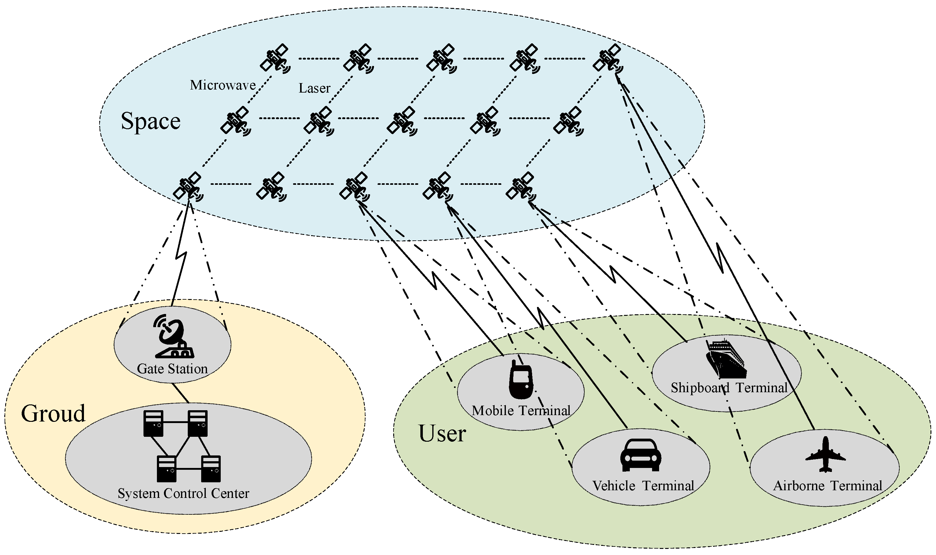
Figure 2. Model architecture of LEO communication satellite constellation system.
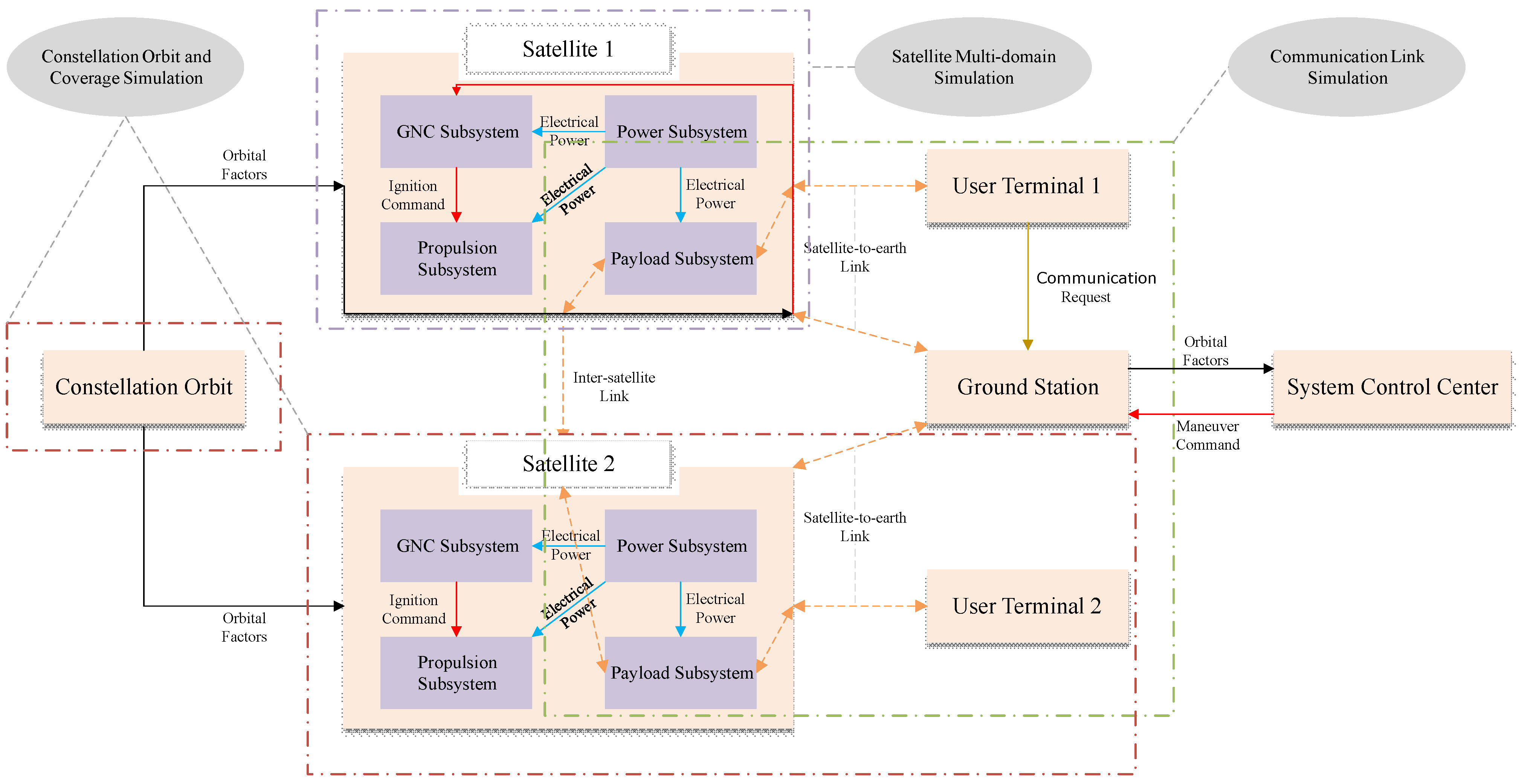
Figure 3. Orbit perturbation model.
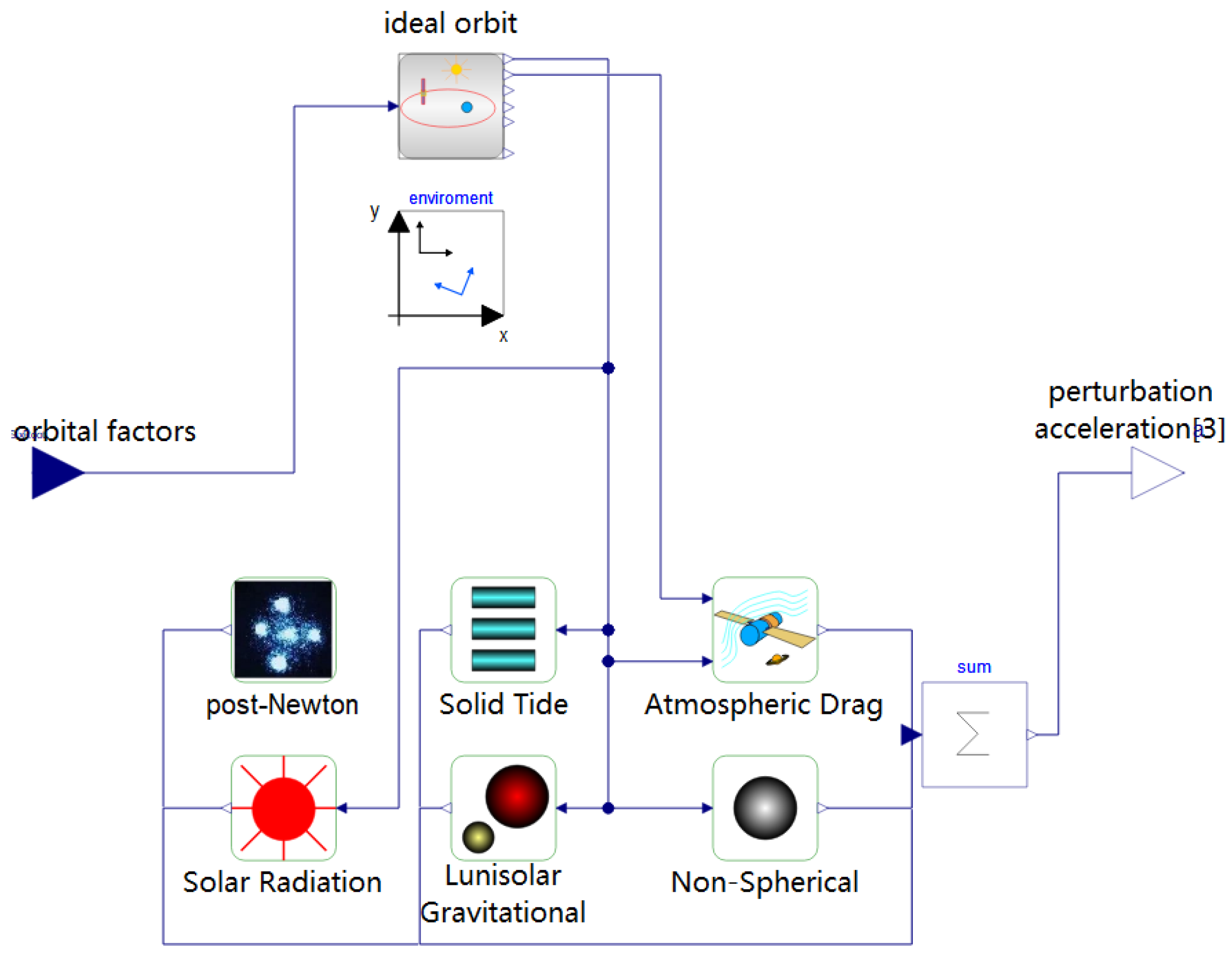
Figure 4. Four main subsystems that make up satellite model in MWorks.
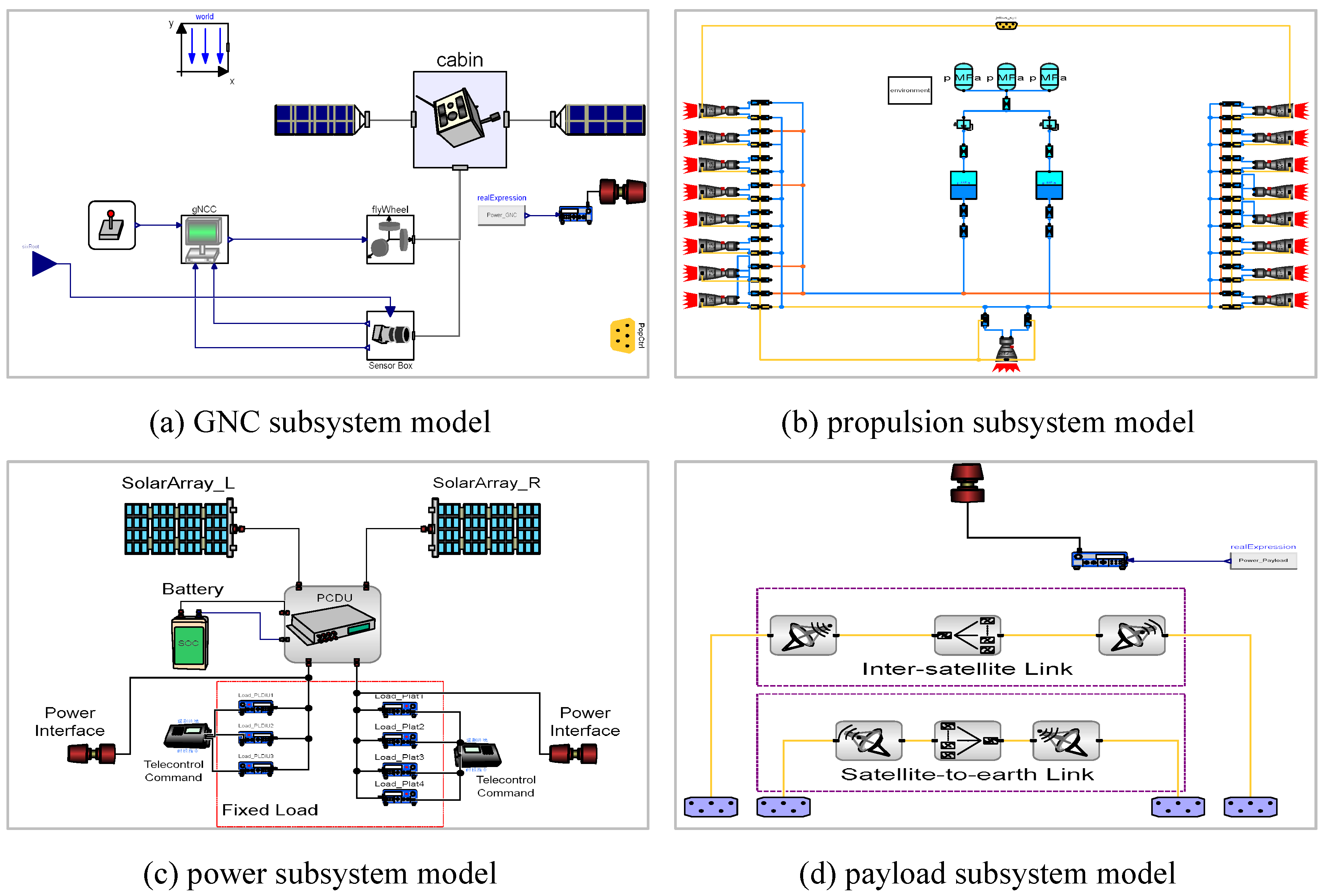
Figure 5. Comparison of MWorks Orbital Calculation Results with STK: (a) True Anomaly. (b) Inertial Position. (c) Subsatellite Point Track.
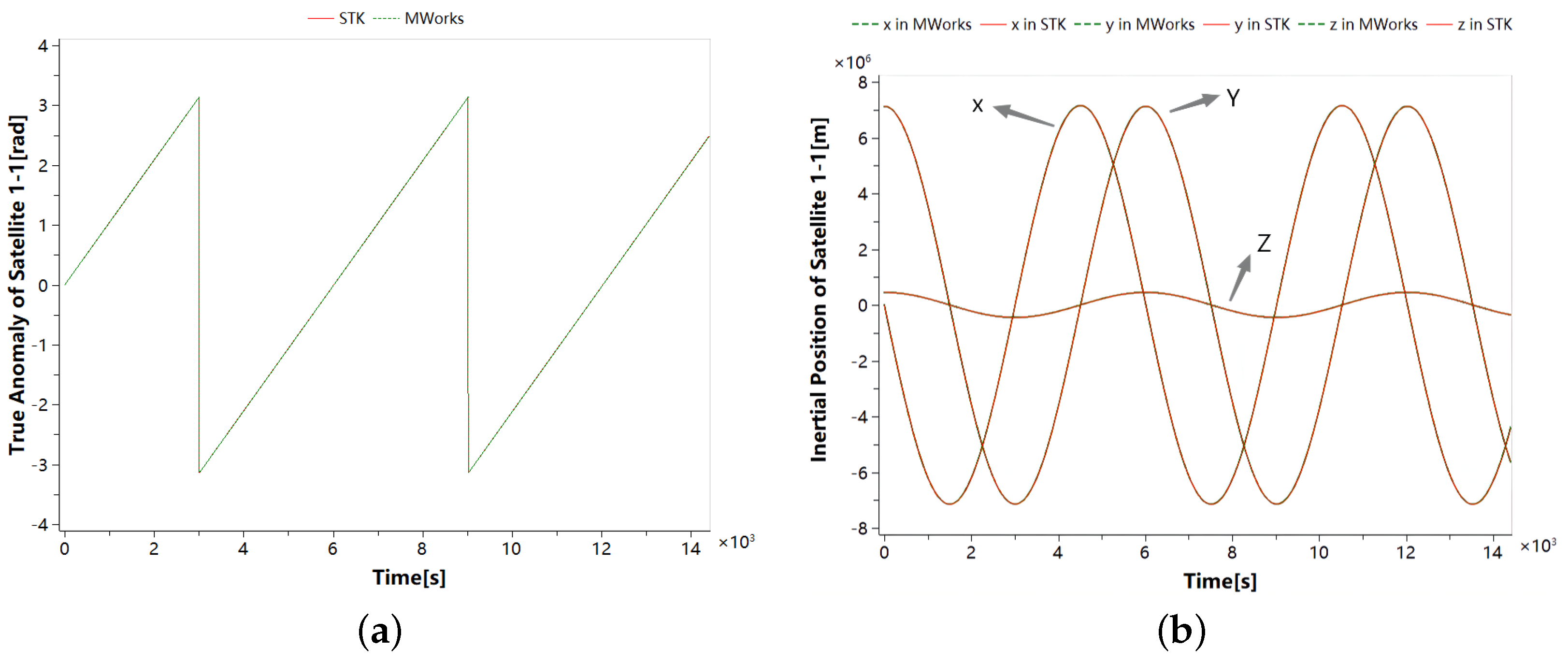
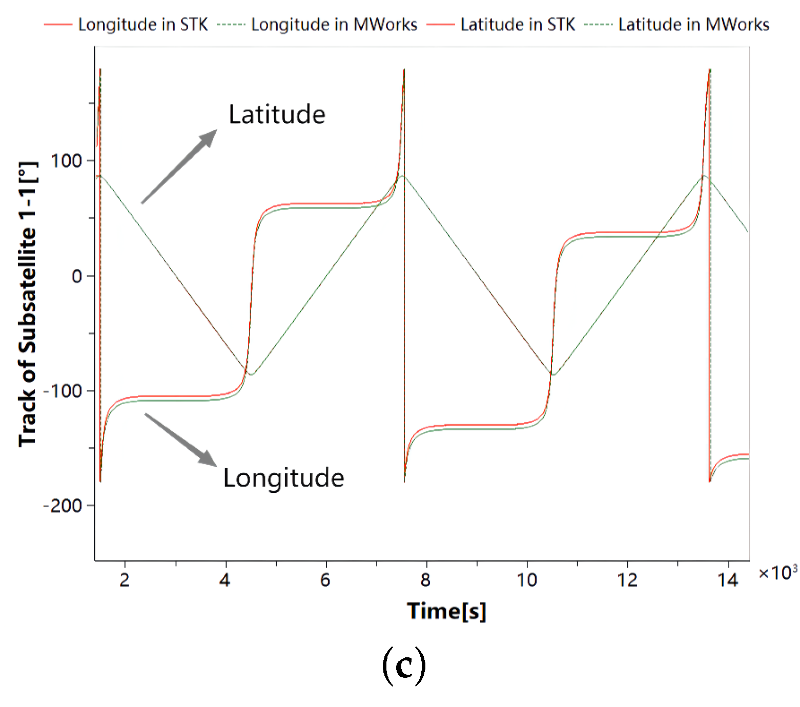
Figure 6. Health monitoring system architecture for satellite constellation.
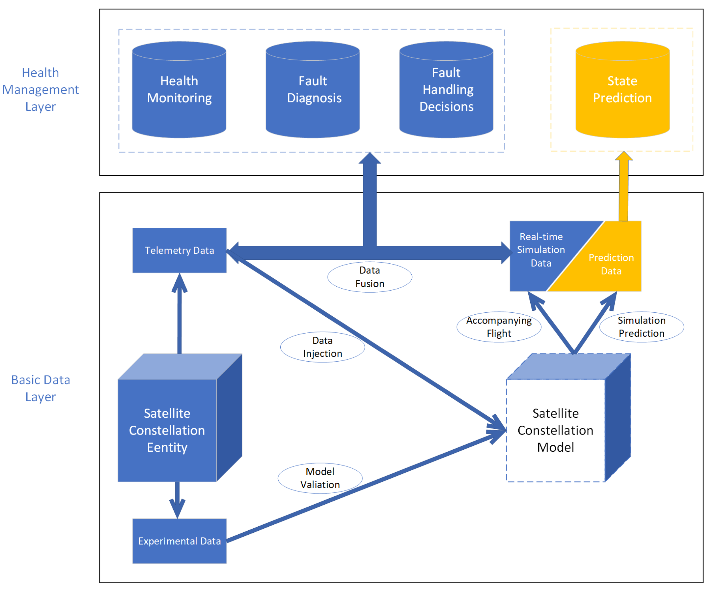
Figure 7. Flow chart of data fusion.
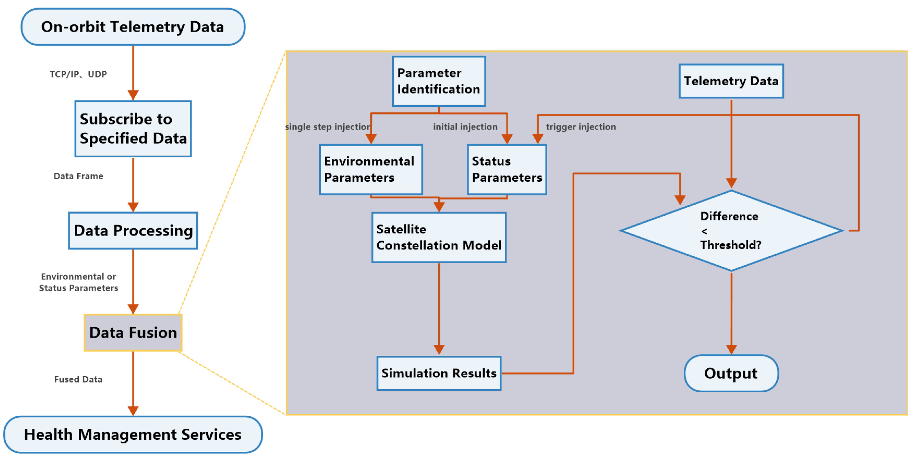
Figure 8. Principle diagram of OCSVM.
Figure 9. Fault Diagnosis Workflow.
Figure 10. Realization process of state prediction.

Figure 11. Example satellite constellation system model.
Figure 12. Simulation Results of PHM System.

Table 1. Key components of satellite constellation system modeling.
| Names | Functions |
|---|---|
| Ground station | Uplink and downlink data forwarding |
| System control center | Generating satellite maneuver command to maintain the stability of constellation configuration |
| Satellite system | The simulation of the operational status of the four subsystems of satellite energy, control, propulsion and payload |
| User terminal | Generating communication requests and sending or receiving communication data |
| Satellite–ground link | The transmission of data between satellite and ground and the calculation of time delay and communication margin |
| Intersatellite link | The transmission of data between satellites and the calculation of time delay and communication margin |
| Constellation system | The calculation of the trajectories of each satellite within the constellation according to the constellation design parameters |
Table 2. Simulation parameters of the satellite constellation model.
| Parameter | Value |
|---|---|
| Number of orbital planes | 6 |
| Number of satellites per plane | 11 |
| Inclination | |
| Eccentricity | 0.00126 |
| Argument of perigee | |
| Ascending node | |
| Mass of satellite | 900 Kg |
| Max flywheel torque | 32 N·m |
| Thrust of thruster | 5 N |
| Maximum power generation | 3200 W |
| Bus voltage | 28 V |
Publisher’s Note: MDPI stays neutral with regard to jurisdictional claims in published maps and institutional affiliations. |
© 2022 by the authors. Licensee MDPI, Basel, Switzerland. This article is an open access article distributed under the terms and conditions of the Creative Commons Attribution (CC BY) license (https://creativecommons.org/licenses/by/4.0/).


No comments:
Post a Comment