NASA Deploys Advanced Radar Technology to Track California's Groundwater

In a groundbreaking initiative that could transform water management in drought-prone regions, NASA has begun using sophisticated radar technology to track the invisible journey of groundwater beneath California's San Joaquin Valley.
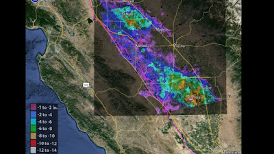
The space agency's Uninhabited Aerial Vehicle Synthetic Aperture Radar (UAVSAR), mounted on a specially equipped aircraft, completed its first flight over the Tulare Basin in late February. This marks the first of six planned missions in 2025 designed to map how and where Sierra Nevada snowmelt replenishes the region's depleted aquifers.
"NASA's technology has the potential to give us unprecedented precision in measuring where snowmelt is recharging groundwater," said Erin Urquhart, program manager for NASA's Earth Action Water Resources program. "This information is vital for farmers, water managers, and policymakers trying to make the best possible decisions to protect water supplies for agriculture and communities."
Detecting the Invisible
What makes this technology remarkable is its ability to detect surface movements smaller than a centimeter – movements that occur as water pressure slightly pushes up the ground above. These minute "surface bulges" create what Stanford University geophysicist Rosemary Knight calls an "InSAR recharge signature."
"For generations, we've been managing water in California without truly knowing where that meltwater seeps underground and replenishes groundwater," said Knight, who leads the research project.
The UAVSAR doesn't directly observe water but instead measures these tiny elevation changes, providing researchers with critical data about the paths water takes as it moves from the Sierra Nevada mountains into the valley's aquifers.
Critical for Agriculture
The stakes couldn't be higher for California's San Joaquin Valley, which produces over a third of America's vegetables and two-thirds of its fruits and nuts. Most farming operations in the region rely heavily on groundwater, especially during drought years.
"Knowing where recharge is happening is vital for smart water management," explained Aaron Fukuda, general manager of the Tulare Irrigation District. "In dry years, when we get limited opportunities, we can direct flood releases to areas that recharge efficiently. In wetter years, it's even more crucial—we need to move water into the ground as quickly as possible to prevent flooding and maximize the amount absorbed."
Part of a Broader Water Monitoring Strategy
The UAVSAR flights complement NASA's broader suite of water monitoring technologies, including the upcoming NISAR (NASA-ISRO Synthetic Aperture Radar) mission, a joint project with the Indian Space Research Organization set to launch soon. NISAR will provide global-scale radar data every 12 days.
NASA's Gravity Recovery and Climate Experiment (GRACE) satellites have already revealed major declines in aquifers across California's Central Valley, though at a coarser resolution than what the new airborne radar can achieve.
"Airborne campaigns like this one in the San Joaquin test how our technology can deliver tangible benefits to American communities," said Stephanie Granger, director of NASA's Western Water Applications Office. "We partner with local water managers to evaluate tools that have the potential to strengthen water supplies across the Western United States."
As climate change continues to alter precipitation patterns and increase drought severity in the American West, these innovative technologies may prove essential for sustainable management of the region's most precious resource: water.
NASA's Uninhabited Aerial Vehicle Synthetic Aperture Radar (UAVSAR) has been instrumental in monitoring groundwater-related land subsidence in California. By utilizing Interferometric Synthetic Aperture Radar (InSAR) techniques, UAVSAR detects minute changes in ground elevation, which are often indicative of groundwater extraction and recharge activities.
Key Applications of UAVSAR in California:
-
Monitoring the California Aqueduct:
- UAVSAR data has revealed significant subsidence along the California Aqueduct, with certain sections experiencing up to 25 inches (64 centimeters) of sinking near Avenal in Kings County. This subsidence has reduced the aqueduct's flow capacity by 20%, necessitating flow reductions to prevent overtopping. https://cvfpb.ca.gov/news/nasa-data-shows-groundwater-pumping-causing-subsidence-damaging-water-infrastructure-informational-briefing-at-cvfpb-meeting-friday-march-24-2017/
-
Assessing Subsidence in the San Joaquin Valley:
- In the San Joaquin Valley, UAVSAR measurements indicated land sinking at rates of nearly 2 inches (5 centimeters) per month in some locations, primarily due to excessive groundwater pumping during drought periods. https://www.jpl.nasa.gov/news/nasa-california-drought-causing-valley-land-to-sink/
-
Evaluating Groundwater Management Efforts:
- The California Department of Water Resources (DWR) utilizes UAVSAR data to inform groundwater management strategies. The data aids in understanding subsidence patterns, which is crucial for maintaining infrastructure integrity and implementing effective water management policies.
These applications underscore UAVSAR's vital role in detecting and tracking groundwater-induced land subsidence, thereby supporting sustainable groundwater management and infrastructure protection in California.
NASA's Uninhabited Aerial Vehicle Synthetic Aperture Radar (UAVSAR)
NASA's Uninhabited Aerial Vehicle Synthetic Aperture Radar (UAVSAR) is an advanced radar imaging system designed to monitor environmental changes, natural hazards, and Earth's surface movements. It is mounted on a Gulfstream-III (G-III) aircraft, which serves as a stable platform for high-resolution radar observations.
Key Features of UAVSAR:
- L-band Synthetic Aperture Radar (SAR): UAVSAR operates in the L-band (1.26 GHz), allowing it to penetrate vegetation, soil, and even ice, providing detailed subsurface imaging.
- Interferometry Capabilities: It can measure ground deformation, such as earthquake-induced shifts, landslides, and glacier movements, with millimeter-level precision.
- Repeat-Pass Imaging: The Gulfstream-III follows precisely the same flight path on multiple occasions, allowing for interferometric SAR (InSAR) comparisons over time.
- Polarimetric Radar Imaging: It captures data in multiple polarizations, enhancing the ability to distinguish between different surface materials and vegetation types.
Gulfstream-III as a UAVSAR Platform
- The G-III jet (tail number N536NA) is a business-class aircraft modified to carry UAVSAR in a pod under its fuselage.
- It flies at an altitude of 41,000 feet (12.5 km) with a speed of about 450 knots (833 km/h), making it ideal for consistent, high-quality radar data collection.
- The aircraft's stability and ability to fly precise repeat paths make it perfect for interferometric studies.
Scientific and Operational Applications
- Earthquake and Tectonic Studies: UAVSAR has been used to monitor fault lines, such as the San Andreas Fault, and assess land deformation after seismic events.
- Flood and Disaster Response: It helps map flooded regions, aiding agencies like FEMA in disaster assessment.
- Glaciology: UAVSAR tracks ice sheet movement in Antarctica and Greenland to understand climate change impacts.
- Forestry and Vegetation Monitoring: By using polarimetric radar, it helps assess forest health, biomass, and deforestation patterns.
- Oil Spill and Coastal Studies: UAVSAR can detect oil spills and assess coastal erosion.
- Volcanology: It tracks volcanic deformation to help predict eruptions.
This system has been in operation for over a decade and continues to provide critical data for scientific research, environmental monitoring, and disaster response efforts worldwide.
SOURCES
Here are some authoritative sources providing detailed information on NASA's Uninhabited Aerial Vehicle Synthetic Aperture Radar (UAVSAR) system mounted on a Gulfstream-III (G-III) jet:
-
NASA's Johnson Space Center (JSC) Gulfstream G-III Overview
- This page offers an overview of the G-III aircraft, highlighting its role in supporting the UAVSAR system and its modifications to accommodate the radar pod.
- URL: https://airbornescience.nasa.gov/category/aircraft/Gulfstream_III_-_JSC
-
NASA Airborne Science Program: Gulfstream III - JSC
- Detailed information about the G-III aircraft's specifications, capabilities, and its integration with the UAVSAR system is provided here.
- URL: https://airbornescience.nasa.gov/category/aircraft/Gulfstream_III_-_JSC
-
NASA's Jet Propulsion Laboratory (JPL) UAVSAR Mission Page
- This source delves into the technical aspects of the UAVSAR instrument, its applications, and its deployment on the Gulfstream-III aircraft.
- URL: https://www.jpl.nasa.gov/missions/uninhabited-aerial-vehicle-synthetic-aperture-radar-uavsar/
-
NASA Armstrong Flight Research Center's C-20A Aircraft
- Information about the C-20A (a military version of the Gulfstream III) and its modifications to support the UAVSAR system is detailed here.
- URL: https://www.nasa.gov/centers-and-facilities/armstrong/c-20a/
-
NASA's Airborne Science Program: UAVSAR
- This page provides an overview of the UAVSAR system, its capabilities, and its role in various Earth science missions.
- URL: https://airbornescience.nasa.gov/category/aircraft/Gulfstream_III_-_JSC


No comments:
Post a Comment