Friday, June 24, 2022

Satellite Communication extend and complement 5G terrestrial networks in unserved or under-served areas

5G and LEO Satellites

Satellite_NASA_010322A
[Satellite - NASA]

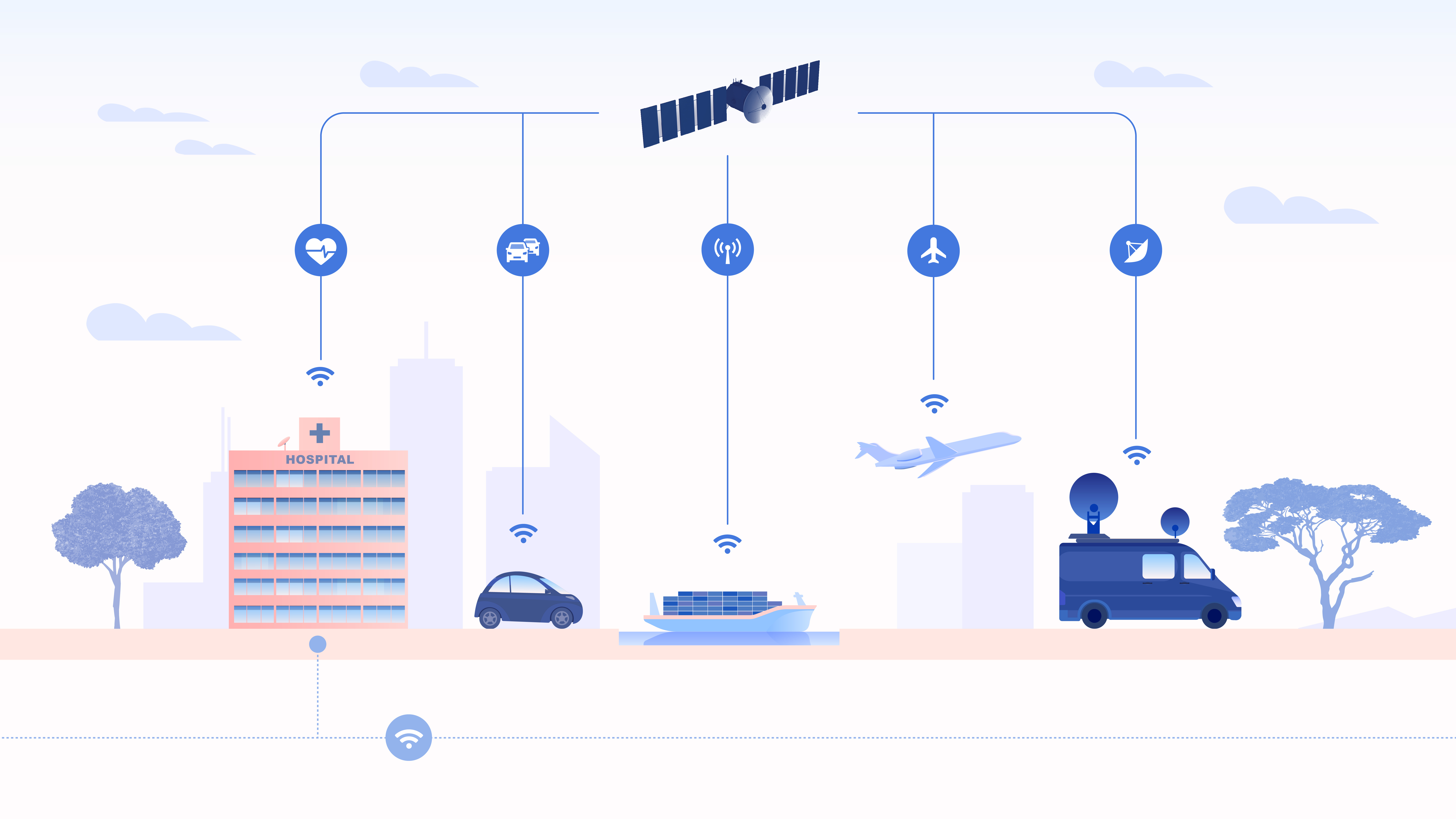
https://www.esa.int/var/esa/storage/images/esa_multimedia/images/2018/05/satellite_for_5g_infographic2/17519478-1-eng-GB/Satellite_for_5G_infographic.jpg- Overview

5G has arrived, and new equipment is currently being installed in densely populated cities across the globe. In many cases, the demand for 5G capacity is exceeding infrastructure improvements, especially in sparsely populated areas that are difficult to access. For years, satellite communication has remained standalone technology, independent of mobile networking. Now with the next generation of satellites – built from 5G architecture –  they will integrate with networks to manage connectivity to cars, vessels, airplanes and other IoT devices in remote and rural areas. 

A series of plans with broad market prospects have therefore been developed. The plans are mainly based on low-orbit micro-satellite constellations, with great advantages in terms of functional density, development cost, launch difficulty, etc.. These constellations can effectively solve the practical problem of networking in remote areas, such as oceans and deserts, and they have irreplaceable advantages in emergency communications, disaster warnings, and maritime rescue.

In the near future, 5G signals will beam down from space and support our ‘terrestrial’ 5G infrastructure on Earth. The end result is a new space race for satellites – promising to offer customers a seamless wireless experience across the entire globe.  


- Low Earth Orbit (LEO) Satellites

A low earth orbit (LEO) satellite is an object, generally a piece of electronic equipment, that circles around the earth at lower altitudes than geosynchronous satellites. LEO satellites orbit between 2,000 and 200 kilometers above the earth. Demands from 5G means cheaper low earth orbit (LEO) satellites are needed to perform multiple satcomms functions. The aim for these is simple in concept: To revolutionize accessibility to space and at a low cost, and with super-fast speeds.

This question of latency is key. Some geostationary satellites at 35,786 km already provide broadband services but their transmissions take about 500-700 milliseconds (ms) to travel up and another 500-700 milliseconds to travel down. This time-lag is why viewers suffer the infuriating time delay during a conversation between the broadcast studio and an outside broadcast unit. If the OB (Outside broadcasting) is more than one satellite ‘hop’ away, then the delay is multiplied. A low Earth-orbiting craft would manage these links in about 25-30 ms, a true fraction of existing satellite links and quite comparable to existing cable or fibre networks. 

The need for ubiquitous coverage for many of the proposed 5G use cases – in particular the Connected Car – has necessitated a plan to include other connectivity solutions such as Wi-Fi and satellite communications in future hybrid networks, in order to ensure that there will be no holes in the 5G coverage map. 


- Low-Orbit Revolution

In the next decade, space will be an important battlefield for the development of next-generation global wireless communication technologies (B5G/6G NTN non-terrestrial network systems). In ten years, there is expected to be more than 60,000 LEO satellites flying at a speed of 7km/s to provide global wireless communication services.

Although satellites can deliver virtually blanket coverage, and potentially also the high data rates demanded for 5G, they do have a disadvantage in terms of latency. Due to the long distances involved, latency for an LEO is typically 30ms – better than the 40ms that is typically achieved by 4G LTE, but poor compared with the 5G target of less than 1ms.

Traditional communication satellites are geostationary and have been in orbit for more than 50 years. GEO satellites weigh more than 1000kg and operate 36,000 kilometers above the earth. These satellites remain in a fixed position relative to any position. Despite Earth’s orbit, this allows ground-based antennas the ability to point directly at the satellite, in a fixed position.  In contrast, Low Earth Orbit (LEO) satellites are miniaturized, orbiting versions that operate between 500 and 2000 kilometers above Earth’s surface and weigh under 500kg. Due to its low orbit, latency is significantly reduced as the satellite is better positioned to quickly receive and transmit data. Unfortunately, this also creates a smaller coverage area so LEO satellites continuously hand off communication signals and traffic across a constellation of satellites. This ensures seamless, wide-scale coverage over a pre-defined geographical area.

 - Private LEO Satellites

LEO satellites are the new space race. The new space race is emerging among tech companies (SpaceX, Amazon, OneWeb, etc.) to deploy LEO satellite constellations to deliver high-speed Internet service to emerging markets and business customers. Each of these companies recognizes the potential of private satellite constellations to not only provide Internet connectivity to rural areas but satisfy the global networking services of tomorrow. 

Eventually, Elon Musk (Starlink) will deploy 40,000 satellites. Greg Wyler (OneWeb) will deploy 2,872 satellites, and Jeff Bezos (Project Kuiper) will deploy 3,236 satellites.

Satellite Communication extend and complement 5G terrestrial networks in unserved or under-served areas – International Defense Security & Technology Inc.


8h

It is projected that soon we will have online more than 6 billion people, 30 billion devices and 50 billion machines. We are moving towards fully “connected world” that’s essentially everyone and everything connected, across every geography, supporting every application from consumer broadband, mobile gaming and connected cars to global business networks, ships, planes, soldiers, first responders and connected farms.

With a significantly higher data rate and very short response times compared to previous standards, 5G will tackle the current requirements for communication in a fully connected society much more comprehensively than has been possible to date. Unlike previous standards, which can be seen as general-purpose technologies to which the different services were tailored and adjusted, the next 5G standard is expected to be able to provide tailored and optimized support for a plethora of services, traffic loads, and end-user communities.

This heterogeneous and optimized framework is reflected in the challenging requirements that 5G systems are expected to meet, e.g., large throughput increase (the target peak data rate should be 20 Gbps in the downlink and 10 Gbps in the uplink), global and seamless connectivity, reliability (99.999% of successful packet reception), and connection density (1 million devices per square km), amongst others.  The new 5G networking architecture promises, exponentially higher efficiencies, massive scalability, significantly lower costs for mobile and fixed networks, IoT applications, and ultra-low latency applications such as connected car and massive M2M.

In the future, 5G networks will represent the global telecommunication infrastructure of the digital economy, which should cover the whole world including inaccessible areas not covered by earlier terrestrial networks. However, there are several use cases where standard terrestrial coverage is either not present or possible, making satellite systems uniquely positioned to provide a solution to bridge this gap.

For areas with a very low-density population, unnecessary communication entities would result in a high average cost per person. And in mountainous regions, it is difficult to deploy infrastructure. Nature disasters like earthquakes, tsunami, and forest fire would destroy the communication entities and result in complete damage for backhaul networks. In this circumstance, it is vital to enhance the robustness of the whole system to make a quick response for rescue.
Satellite communication will play a significant role in 5G and beyond as a complementary solution for ubiquitous coverage, broadcast/multicast provision, aeronautical & maritime communications, emergency/disaster recovery, and remote rural area coverage.

5G has the vision to become a ‘Network of Networks’ integrating multiple access technologies, including Satellite. 5G’s standardized service orchestration and the 5G NR extension for Non-Terrestrial Networks will make Satellite seamlessly integrable with the mainstream Telco ecosystem, dropping barriers for Satcom adoption.

The 5G for all – inclusive connectivity requires satellite.

› Telemedicine – making the right to healthcare a logistical reality
› Financial Inclusion – providing connectivity for banking and social programs
› National Security/Borders – giving law enforcement agencies access to broadband in the field
› Farming – precision agriculture raises incomes, creates opportunities.
› Education – extending educational opportunities to all students in a country
› SMEs – connecting businesses to global markets, enabling local e-commerce
› Disaster Recovery – resilient links, rapid deployment

New Space revolution

Recent years have also seen several advances in satellite systems and networks, allowing better efficiency, reliability, increased data rates, and new applications. New paradigms such as mega constellations are manifest, triggering significant investments in future constellations. By 2020-2025 there will be more than 100 High Throughput Satellite (HTS) systems using Geostationary (GEO) orbits but also mega-constellations of Low Earth Orbit (LEO) satellites, delivering Terabit per second (Tbps) of capacity across the world.

The future mega-constellations with 100s-10,000s of low-earth-orbit (LEO) satellites, such as Starlink [STARLINK], Kuiper [KUIPER] and OneWeb [ONEWEB] promise competitive low latency and high capacity to terrestrial networks. They expand global high-speed Internet to remote areas that were not reachable by terrestrial networks, resulting in a tens-of-billions-of-dollar market with 3.7 billion users in rural areas, developing countries, aircraft, or oceans

Satellite integration with 5G requirements

Typically, what satellite provides is coverage extension to small cell urban 5G. The booming of new satellite payloads for geostationary earth orbit (GEO) satellite platforms and constellations comprised of low earth orbit (LEO) satellites have forged the integration of satellite and terrestrial networks into an essential network foundation to achieve the quality of service that cannot have by leveraging either of two networks independently.

The deployment of 5G Release 15 networks by terrestrial mobile network operators (MNOs) has already begun and delivers enhanced mobile broadband (eMBB) services in small cells. The integration of satellite components, so-called Non-Terrestrial Networks (NTNs), in terrestrial infrastructure is currently studied and will be specified in Release 17. The widespread use of communication satellites in the future network-of-networks is envisaged by 2023.

3GPP  Study Item for New Radio-based, i.e., 5G, Non-Terrestrial Networks aimed at deploying satellite systems either as a stand-alone solution or as integration to terrestrial networks in mobile broadband and machine-type communication scenarios. The role of NTN in 5G systems is expected to be manifold, including:

i) the support to 5G service provision in both un-served areas that cannot be covered by terrestrial 5G networks (isolated/remote areas, onboard aircraft or vessels) and underserved areas (e.g., suburban/rural areas);

ii) improve the 5G service reliability thanks to better service continuity, in particular for mission-critical communications or Machine Type Communications (MTC) and Internet of Things (IoT) devices, M2M/IoT devices or for passengers on board moving platforms; and

iii) to enable the 5G network scalability by providing efficient multicast/broadcast resources for data delivery.

Non-Terrestrial Networks and, thus, SatCom systems can bring significant benefits to future 5G services thanks to both their wide area service coverage and the significantly reduced vulnerability to physical attacks or natural disasters. Thanks to their intrinsic ubiquity and broadcasting capabilities, satellite networks can play multiple roles in 5G. The satellite can act as a main single backhaul segment for rural areas, aircrafts, vessels, trains, or as additional backhaul means to opportunistically provide additional connectivity/bandwidth resources, also improving service continuity, or as a pure transport subnetwork.

Airplanes, trains, boats and other vehicles that frequent regions of the planet beyond the reach of cellular companies will continue to rely on satellite links, experts agreed. In terms of system deployment, both stand-alone 5G SatCom and integrated satellite-terrestrial solutions can be envisaged.

Challenges

A salient feature for LEO mega-constellations is their high relative motions to the rotating earth. Unlike geosynchronous satellite or terrestrial networks, each LEO satellite moves fast ( > 25,000 km/h), causing short-lived coverage for terrestrial users (less than 3 minutes). This yields diverse challenges for the traditional network designs.

Terrestrial users access satellite networks via terminals (e.g., satellite phones, onboard dishes, IoT endpoints) or ground stations. Ground stations can serve as network gateways (e.g., carrier-grade NAT in Starlink [STARLINK-CGNAT] and Kuiper [KUIPER-CGNAT]) and remote satellite controllers (e.g., telemetry, tracking, orbital update commands, or centralized routing control).

In terrestrial and GEO satellite networks, the logical network topology, addresses, and routes are mostly stationary due to fixed infrastructure. Instead, LEO mega-constellations hardly enjoy this luxury, whose satellites move at high speeds (about 28,080 km/h). The earth’s rotation further complicates the relative motions between space and ground. For all mega-constellations, the topology changes every 10s of seconds.

In terrestrial mobile networks (e.g., 4G/5G), such physical link churn can be masked by handoffs without incurring logical topology changes. This method works based on two premises. First, all link churns occur at the last-hop radio due to user mobility, without affecting the infrastructure topology. Second, all cellular infrastructure nodes are fixed, resulting in a stable logical topology as “anchors”

However, neither premise holds in non-geosynchronous constellations. Instead, infrastructure mobility between satellites and ground stations becomes a norm rather than an exception. This voids cellular handoffs’ merits to avoid propagation of physical link churns to logical network topology: They are designed for user mobility only, and heavily rely on the fixed infrastructure as “anchors.” Therefore, 5G NTN lists satellite handoffs as an unsolved problem, and the latest 3GPP 5G release 17 defers its mobility support for satellites due to significant architectural changes. While Starlink uses handoffs to migrate physical links between satellites and ground stations (every 15s [STARLINK-CGNAT]), its logical topology and routing are still be repeatedly updated at high costs

Typical satellite channel impairments, as large path losses, delays, and Doppler shifts, pose severe challenges to the realization of a satellite-based NR network. When considering satellite communications, the Doppler shift can be caused by the satellite movement on its orbit and the user terminals’ mobility on ground.

However,  current satellite systems are constrained by spectrum utilization and regulatory constraints on power flux density driven by spectrum sharing between satellite and terrestrial systems. Satellite requires very specific know-how and uses proprietary standards, making integration with mainstream network highly complex.

Enabling Technologies

Megaconstellations are enabled by recent advances in satellite miniaturization and rocket reusability.

Early satellite communications favor the simple “bent-pipe-only” model, i.e., satellites only relay terrestrial users’ radio signals to the fixed ground stations without ISLs or routing. This model has been popular in GSO satellites with broad coverage. To access the network, both terrestrial users and ground stations must reside inside the satellite’s coverage. Due to each LEO satellite’s low coverage, most users in remote areas with sparse or no ground stations cannot be served. Instead, modern LEO mega-constellations favor satellite routing to expand global coverage or enable Internet backbones. To date, inter-satellite links are still under early adoption.

As a near-term remedy, ground station-assisted routing is currently adopted. There are two variants. The GS-as-gateway is adopted by Starlink and Kuiper. Each ground station is a carrier-grade NAT that offers private IP for terrestrial users. The GS-as-relay mitigates ISLs with ground station-assisted routing, but is vulnerable to intermittent space-terrestrial links in Ku/Ka-bands. Like the “bent-pipe only” model, both heavily rely on ubiquitous ground station deployments in remote areas and even oceans, thus lowering competitive edges to terrestrial networks.

The plethora of recent advances in technologies also make it possible to merge the satellite communication systems and terrestrial networks, such as software defined networks, the Internet of things, cognitive radio, and high throughput satellites. The cost of manufacturing satellites and access to space is dramatically falling, new materials such as flexible photovoltaic and lightweight composite structures, together with virtualized network functions and software radio platforms increase capability and flexibility.

In the edge computing scenario, satellite interconnectivity may be exploited for the unicast/multicast/broadcast geographical distribution of video, audio, and application software binaries to a large number of terminals simultaneously.

As such, 5G will dramatically change how satellite is integrated into the mainstream, achieving full interoperability within the end-to-end 5G network.  Adapting satellite to work seamlessly with 5G cellular and terrestrial networks will empower end users anywhere in the world with consistent, reliable, high-performance experiences. Service providers will be able to decide how they can best serve customers — whether it’s through satellite, terrestrial or mobile networks, or all of them combined.

Mobile network operators will be able to complement their 5G services with satellite connectivity to offload their terrestrial networks in a large scale. They will be able to take advantage of satellite’s inherent multicasting/broadcast functionality for new use cases, such as connected car, while preserving high-value wireless spectrum for latency-sensitive services. Or, they can use satellite’s longer range to complement the buildout of 5G in remote areas where building terrestrial networks for enhanced broadband services is simply too cost prohibitive.

In order to enable this deep integration between satellite and 5G, a number of actions should be undertaken to bring state of-the-art satellite technologies closer to the virtualization paradigm used within the 5G architecture. Many issues are related to physical layer aspects: “non-orthogonal multiple access (NOMA), massive multiple input and multiple output (MIMO), cooperative communications and network coding, full duplex (FD), device-to-device (D2D) communications, millimeter wave communications, automated network organization, cognitive radio (CR)”

The advanced communications of 5G are expected to transform three major use cases: Enhanced Mobile Broadband (eMBB), Ultra-Reliable and Low-Latency Communications (URLLC), and Massive Machine-Type Communications (mMTC). Satellite has a critical role to play in each of these categories.


Enhanced Mobile Broadband (eMBB)

According to this scenario, satellite networks are capable of maintaining data transfer at speed up to several gigabits per second, meeting the requirements for extended services of mobile broadband eMBB. Nowadays, satellite technologies can broadcast thousands of channels with the content of high bandwidth (HD and UHD). In its turn, this potential can be used to support the mobile network services of future generation. At present, satellites are being used as transport networks within 2G/3G in many regions of the world, whereas high-throughput satellites (HTS) of modern and future generations on geostationary and non-geostationary orbits can maintain transport infrastructure of mobile networks 4G/LTE and 5G in future.

With 5G comes the opportunity to offer vastly enhanced and faster broadband connectivity (e.g., voice, video, data) to wide area networks, hotspots for mobile or fixed networks.

• 5G to Premises: Satellite will complement terrestrial networks, such as broadband connectivity to a home or office, in an underserved area, or to enterprise sites as a backup.
• 5G Fixed Backhaul: Satellite will bring broadband connectivity where it is difficult to deploy terrestrial connections in rural and remote areas across a wide geographic region only or best covered by satellite.
• 5G Mobility Backhaul: Satellite will bring broadband connectivity to remotes or UEs on the move, such as airplanes, trains, vehicles or maritime vessels.

An exemplary use case of satellites in 5G is backhauling of cell traffic to connect the mobile network operators MNO core network with the edges. In current terrestrial deployments, this backhaul is based on fiber connections or microwave links. Thus, the control plane in Release 15 relies on continuous backhaul connections between the network components. However, a next-generation Node B backhauled via satellite has to handle longer signal delays as opposed to short terrestrial connections over fiber. If the gNB itself is mobile, link outages of varying duration need to be considered for the satellite backhaul link.

In the above context for worldwide 5G systems, the integration of terrestrial systems with Geostationary Earth Orbit (GEO) satellites would be beneficial for global large-capacity coverage, but the large delays in geostationary orbits pose significant challenges. However, to avoid the above issues, significant attention is being gained by Low Earth Orbit (LEO) mega-constellations, i.e., systems in which hundreds of satellites are deployed to provide global coverage, as also demonstrated.

Facebook to Amazon to SpaceX to OneWeb are in the early stages of deploying thousands of tiny, low-Earth orbit (LEO) satellites that are intended to offer much faster and cheaper satellite-based Internet services than previous offerings. For example, OneWeb reported last year that it was able to clock speeds of 400Mbit/s with latency of 32 ms from its initial batch of LEO satellites.

Ultra-Reliable and Low-Latency Communications (URLLC)

The second set of 5G use cases are URLLC applications that are particularly important for mission-critical and pseudo-real-time applications. Let’s consider the case of autonomous cars, where latency is absolutely critical. To operate successfully, autonomous cars need to be able to talk to each other and their surroundings (also referred to as ‘vehicle-to-everything’ or ‘V2X’) within milliseconds.

It is clear that satellite connectivity, regardless of its orbit (GEO, MEO, LEO), will not support certain latency sensitive applications and services, and therefore is not an optimal access technology option in V2X or autonomous driving per se; however, it will have a role in the connected car application at large, such as in passenger infotainment and car software updates.

In the case of the connected car, multicasting will allow media streaming, such as OTT and software updates, to be broadcasted to millions of cars simultaneously, vastly reducing the congestion that would otherwise be put on the base station. Satellite will complement the terrestrial buildout through traffic offloading. This would also require the endpoints (base stations or cars) to be hybrid in nature, with satellite and cellular connectivity modem technology incorporated.

Satellite communication systems gained notoriety by owing to its and their ability to meet the case concerning the requirements for network signal delays, aiming at procuring critical and highly reliable communications. The principal users of these networks are international broadcasters, mobile network operators, governmental bodies, and commercial users. The applications that turn out to be more sensitive to signal delays can be bolstered via new medium and low earth orbit satellite networks, which will to be deployed.

Massive Machine-Type Communications (mMTC)

The third set of use cases are mMTC for M2M or IoT devices and sensors. SDN functionality will play a critical role here as it allows for a given UE to be serviced with far fewer resources, in return enabling several UEs to be serviced with the equivalent resource of a single 4G UE. This already showcases the promised scale that comes with 5G.

The 5G architecture needs to dramatically scale as it will be connecting and backhauling data from millions of smart devices and sensors inside homes and urban infrastructure, as they will become prevalent in smart cities of the future. While small in nature, the sheer aggregated volume of this M2M and IoT connectivity will have a major impact on the network load. In order to offload 5G networks, one opportunity for satellite can be backhauling non-latency sensitive data from these devices, or more precisely, from the aggregation points
back to the core network.

Satellite communication systems are already keeping up the technology of SCADA and other global applications for cargo and object tracking in the context of IoT devices mass use. Their capabilities can be scaled up to support devices and services of IoT within the direct control channel or as a feedback line with IoT and M2M devices from remote locations, ships, and other carrying vessels.

5G Satellite projects

In addition to the 3GPP standardisation effort, funded projects are currently addressing SatCom-based 5G systems, as, for instance:

i) the EC H2020 project VITAL (VIrtualized hybrid satellite-Terrestrial systems for resilient and fLexible future networks), in which the combination of terrestrial and satellite networks is addressed by bringing Network Functions Virtualization (NFV) into the satellite domain and by enabling Software-Defined-Networking (SDN)-based, federated resources management in hybrid SatCom-terrestrial networks,;

ii) the EC H2020 project Sat5G (Satellite and Terrestrial Network for 5G), which aims at developing a cost-effective SatCom solution by means of satellite gateway and terminal virtualisation and use cases demonstration;

iii) the ESA project SATis5 (Demonstrator for Satellite Terrestrial Integration in the 5G Context), in which a set of relevant satellite use cases for 5G in the areas of enhanced Mobile BroadBand (eMBB) and massive IoT deployments will be demonstrated,; and

iv) the H2020 project SANSA (Shared Access Terrestrial-Satellite Backhaul Network enabled by Smart Antennas), aimed at to enhancing the performance of mobile wireless backhaul networks, both in terms of capacity and resilience, while assuring an efficient use of the spectrum,

The call for proposals is part of a joint effort by the UK Space Agency, the European Space Agency (ESA) and the Department for Digital, Culture, Media & Sport (DCMS), with hopes of increasing connectivity and closing the digital divide for businesses in the sector. “Access to constant connectivity regardless of location offers huge benefits,” said Catherine Mealing-Jones, director of growth at the UK Space Agency. “We’ve seen through the current pandemic, that logistics are vital to keeping the country going and space technology is a key part of making that happen.”

Magali Vaissiere, ESA director of telecommunications and integrated applications added: “This is a great opportunity for ESA to join forces with DCMS and UK Space Agency and prove the key role that satellite communications will play in the future converged 5G networks. “In the context of the ESA 5G Strategic Programme Line, this Call for Proposals is intended to stimulate the emergence of sustainable applications relying on innovative 5G solutions, starting from the logistics sector.”

Boeing presented NGSO system

The Boeing company requested the US Federal Communications Commission for permission to launch and operate fixed satellite service (FSS) network on non-geostationary orbit (NGSO). The network would operate in a low-Earth orbit (LEO) in the frequency band 37.5–42.5 GHz (space-Earth) and in the frequency bands 47.2–50.2 and 50.4–52.4 GHz of V-band (Earth-space); it would be used as a NGSO system providing solution of 5G satellite segment operation issues.

The Boeing proposed NGSO system  considered as a 5G satellite segment that is designed to provide a wide range of modern telecommunication services alongside with 5G internet services for a broad types of V-band earth stations and user terminals. V-band user terminals use modern antenna arrays for transmitting and receiving broadband signals in channels of different pass bands. It is to note that a high throughput is supported by multichannel and multiple polarization terminals.

The Boeing presented NGSO system would consist of 2956 LEO satellites for the fixed satellite service network providing high throughput low latency access for user terminals connected through gateway (“hubs”) access to 5G network and to a terrestrial optic-fiber network as backhaul connecting to 5G. The system gateways are expected to be located outside the densely populated areas in the regions with relatively low consumer demand for 5G services. Each NGSO satellite would form beams, corresponding to cell diameter from 8 up to 11 km on the Earth surface within the overall satellite coverage area.

The NGSO system gateways would operate in the same V-band as user terminals. These gateways would support both frequency and polarization selection of signals with two types of antennas polarization LHCP (Left Hand Circular Polarized) and RHCP (Right Hand Circular Polarized). In addition, the access gateways may contain more than one antenna thereby providing simultaneous access to multiple NGSO satellites visible from a relevant access gateway. At the first stage of deployment, the Boeing NGSO system would comprise a constellation of 1396 LEO satellites in an altitude of 1200 km. The initial satellite constellation would consist of 35 circular orbital planes with an inclination of 45° and additional 6 circular planes inclined at 55°.

The NGSO system payload  would use the improved space-time processing in the course of antenna beam-forming as well as on board digital processing so as to generate thousands of narrow-band beams to provide 5G network services through satellite segment on the Earth surface.

Each satellite up-link or down-link may consist of up to five channels of 1 GHz pass band resulting in a total pass band of 5 GHz depending on instant capacity required for a cell supported by a relevant satellite antenna beam. Any satellite UL-channel may be connected to any satellite DL-channel in compliance with used connection algorithm. Boeing company estimation results show that usage of a satellite network for fixed satellite channels and its spectrum sharing with a 5G terrestrial network in the frequency band 37.5–40.0 GHz would be feasible under the following conditions:

  • the frequency band 37.5–40.0 GHz is used only for signal reception in FSS network downlink;
  • spectrum sharing between 5G satellite segment and 5G terrestrial segment is feasible due to high satellite elevation angles;
  • applying of space-time selection beam-forming methods for terminal antennas of satellite networks and 5G equipment in the aim to achieve higher data rate.

The power flux density (PFD) limits approved by ITU  would provide protection for 5G network terrestrial segment from interference caused by FSS satellite network downlinks subject to meeting the requirement of minimal reducing of 5G terrestrial network signal level to 0.2–0.6 dBW.

As confirmation, possibility of successfully utilization integrated satellite segment into 3GPP 5G testbed networks was the last demonstration of Surrey University achievements in 5G satellite network development. Three use cases were demonstrated over a live satellite network via Avanti’s GEO HYLAS 4 satellite and using iDirect’s 5G-enabled Intelligent Gateway (IGW) satellite ground infrastructure that to 5G testbed core network of the University of Surrey to 5G UE terminals. All the 5G testbed use cases used this integrated 5G satellite system for the live satellite connectivity. The use-case for 5G moving platform was demonstrated over SES’s O3b MEO satellite system, using real terminals and 5G core network.

From the networking viewpoint, network virtualization is a concept that will bring benefits in terms of lower costs, higher flexibility, and tailored service provision. The adoption of SDN and NFV technologies into the satellite domain is seen as a key element to accomplish
satellite and mobile terrestrial networks integration, allowing the creation of a heterogeneous 5G network architecture and the provision of dedicated slices. In this vision, satellite network architectures should be augmented with autonomous and flexible management of service lifecycle operations, including the real-time monitoring of performance and other 5G KPIs. The integration of terrestrial and satellite networks in 5G through the virtualization of network functions, the provision of slices, and the use of general-purpose instead of ad-hoc hardware, will not be immediate. Moreover, the investments required to design and deploy a GEO/LEO satellite communication network are huge, so current satellite operators cannot replace costly hardware components before the end of the
scheduled network lifetime, especially concerning on-board technologies.

One of the most important issues of 5G satellite segment future development may refer to shared spectrum usage in the frequency bands allocated to 5G satellite and terrestrial segments on the primary basis. Also urgent is the issue of intersystem electromagnetic compatibility of aboard equipment and earth stations with base stations and user devices of 5G terrestrial segment.

Omnispace tests initial 5G-via-satellite capability for US Navy and USMC, reported in March 2021

Omnispace has successfully demonstrated an initial 5G-via-satellite capability for the US Navy and US Marine Corps (USMC). The capability was tested in a LinQuest lab demonstration. Omnispace’s technology is being piloted in associated with Verizon’s new 5G Living Lab. The National Security Innovation Network (NSIN) selected the company last year to showcase its 5G non-terrestrial network (NTN) connectivity solutions for use by the US government and military. Omnispace Government and International Markets vice-president Campbell Marshall said: “Omnispace is honoured to have been selected to work with the US Navy and Marines to demonstrate 5G capability from space.

“The development of standards-based 5G non-terrestrial network (NTN) technology powered by Omnispace’s S-band spectrum will allow small tactical 5G devices to communicate directly and seamlessly with 5G-capable satellites and terrestrial networks, giving our warfighters ubiquitous global connectivity and true comms-on-the-move.” During the trials, LinQuest’s lab facility in Northern Virginia and several commercial-off-the-shelf 5G devices were used. Through an emulated 5G radio access network (RAN), the devices were able to communicate voice and data services to Omnispace’s on-orbit satellite. Marine Corps lieutenant colonel Brandon Newell said: “5G will be a critical technology for our military operations in the very near future, and those operations aren’t limited to dense urban environments where most 5G infrastructure is being deployed.

Verizon 5G  and Amazon Project Kuiper collaboration

Strategic collaboration aims to pair Verizon’s terrestrial mobile network with Amazon’s low Earth orbit (LEO) satellite network, Project Kuiper. Project Kuiper to deliver cellular backhaul solutions to extend Verizon’s 4G/LTE and 5G data networks, connecting rural and remote communities in the U.S.

Verizon and Project Kuiper to explore joint connectivity solutions for domestic and global enterprises across agriculture, energy, manufacturing, education, emergency response, transportation and other industries.

To begin, Amazon and Verizon will focus on expanding Verizon data networks using cellular backhaul solutions from Project Kuiper. The integration will leverage antenna development already in progress from the Project Kuiper team, and both engineering teams are now working together to define technical requirements to help extend fixed wireless coverage to rural and remote communities across the United States.

he Kuiper System is designed with the flexibility and capacity to support enterprises of all sizes. By pairing those capabilities with Verizon’s wireless, private networking and edge compute solutions, the two will be able to extend connectivity to businesses operating and deploying assets on a global scale.

Market

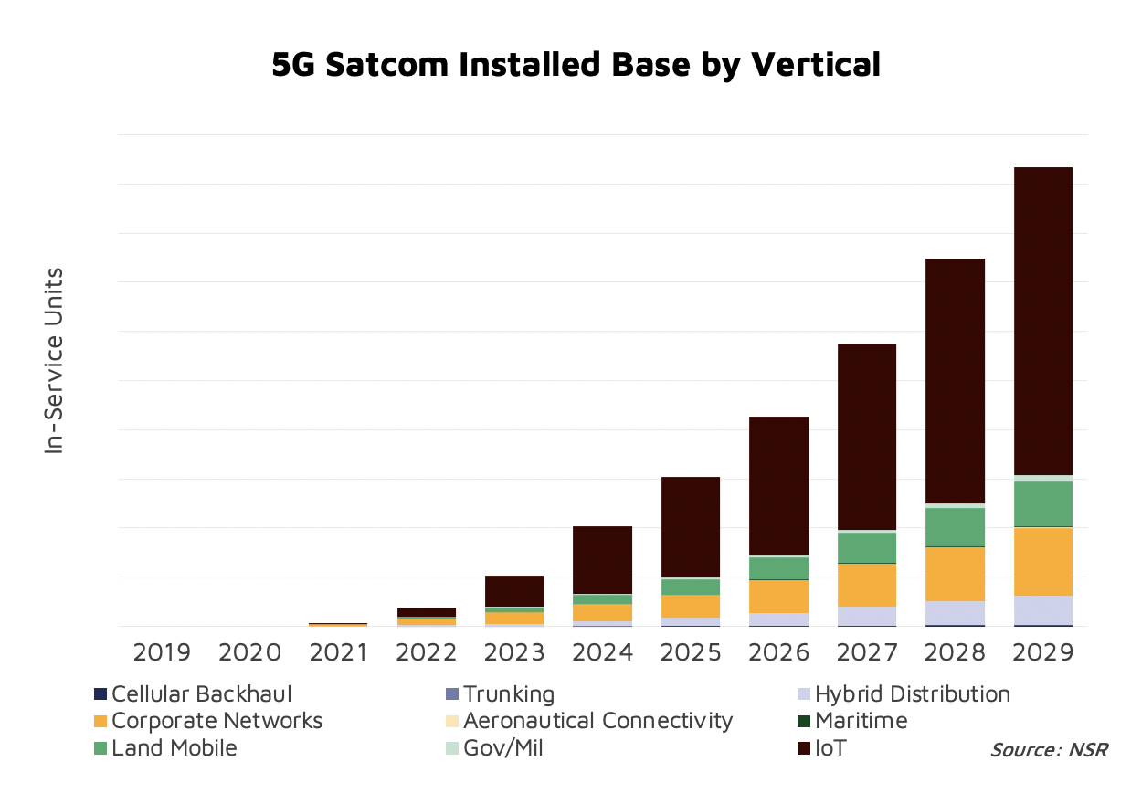
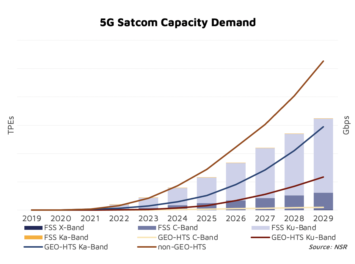
NSR’s 5G via Satellite: Impacts, Demand and Revenue Potential report forecasts that 1 in every 4 USD in FSS Satellite Capacity Revenues for Data verticals will be generated from 5G traffic by 2029.

The Satellite IoT segment will undoubtedly witness significant benefits from 5G. In a segment where remotes often send just a few Kbs from time to time, bandwidth is not the main driver in the TCO. On the other hand, terminal cost can make or break the business case. Satellite today uses proprietary systems with limited scale driving terminal cost in the order of ~$100. However, adopting the 5G NR waveform would open access to mainstream chipsets and devices, dropping terminal cost to ~$10s. If that is not enough, instead of using specialized resellers, Satellite IoT would gain access to mainstream sales channels and a massive addressable market skyrocketing adoption for Satellite services.
5GvS_Tab1_Pic2.png

MNOs have made it very clear that Enterprise Services are one of their key focus to drive 5G incremental revenues. 5G networking tools are very powerful allowing for network slicing to route traffic optimally depending on the application requirements. If Satellite is able to integrate in the 5G ecosystem, there will be numerous opportunities emerging from the unique set of attributes that a Satellite overlay can introduce to terrestrial networks (security, redundancy, broadcasting, etc.).
5GvS_Tab1_Pic3.png

5G is a unique opportunity for Satellite to become a mainstream technology. But to realize this potential, the industry must ensure that it can meet 5G standards both at the network orchestration level and at the radio access level (for narrowband applications like IoT). This would drop historical barriers for Satcom such as integration complexities or high TCOs.

 Network attributes highly valued by both Enterprise and customers match very well what Satellite can offer to the ecosystem (enhanced levels of security, coverage, etc.). Network attributes such as slicing or ubiquity ensure a prolific future for satellites in the 5G ecosystem.

References and resources also include:

https://www.idirect.net/wp-content/uploads/2019/01/The-5G-Future-and-the-Role-of-Satellite-White-Paper-2019.pdf

https://spacenews.com/what-the-satellite-industry-needs-to-know-about-where-5g-stands/

https://arxiv.org/pdf/1806.02088.pdf

https://www.intechopen.com/online-first/prospects-of-5g-satellite-networks-development

https://www.naval-technology.com/news/omnispace-tests-initial-5g-via-satellite-capability-for-us-navy-and-usmc/

https://www.nsr.com/research/5g-via-satellite-impacts-demand-revenue-potential-to-2029/

https://www.ietf.org/id/draft-li-istn-addressing-requirement-00.html


Satellite Gateway and Hub technology trends

Satellite Gateway and Hub technology trends – International Defense Security & Technology Inc.:

3h

gateway-660x330.jpg

Internet access has historically been terrestrial or based on networks, such as fiber or other data cabling that is based on the ground.  Cellular data is another common method of providing internet access. Satellite Internet access is Internet access provided through communication satellites. Satellite connections are often employed in remote areas that are not serviced by terrestrial networks or cellular data. They also can be effective backup systems for critical business and government services.


Satellite Internet generally relies on three primary components: a satellite – historically in geostationary orbit (or GEO) but now increasingly in Low Earth orbit (LEO) or Medium Earth orbit MEO). Modern consumer-grade satellite Internet service is typically provided to individual users through geostationary satellites that can offer relatively high data speeds, with newer satellites using Ku band to achieve downstream data speeds up to 506 Mbit/s. In addition, new satellite internet constellations are being developed in low-earth orbit to enable low-latency internet access from space.


The second is the user terminal to serve each subscriber— the antenna on a home, business, ship, plane, or other location and transceiver.


The third is the ground network, a collection of earth stations connected to the internet by fiber optic cable.  These ground stations are known as gateways that relay Internet data to and from the satellite via radio waves (microwave). Another component of a satellite Internet system is a centralized network operations center (NOC) for monitoring the entire system.


Satellite Gateway

The system of gateways comprising the satellite ground system provides all network services for satellite and corresponding terrestrial connectivity. Each gateway provides a multiservice access network for subscriber terminal connections to the Internet.


A satellite gateway also referred to as a teleport or hub, is a ground station that interfaces one side with the fleet of satellites orbiting Earth and the other side with a national fiber network or LAN (Local Area Network).  It houses the large antennas and equipment that convert the Radio Frequency (RF) signal to an Internet Protocol (IP) signal for terrestrial connectivity and vice versa as per terrestrial connections. IP refers to Internet Protocols used for internet access and for data transfer. Voice information can also be carried using Voice over IP protocol.


Working in concert with a broadband gateway, the satellite operates a Star network topology where all network communication passes through the network’s hub processor, which is at the centre of the star. With this configuration, the number of ground stations that can be connected to the hub is virtually limitless.


Traditionally, gateway antennas are quite large — 7 meters or more in diameter. They’re often accompanied by a secure, air-conditioned room or shelter full of servers and other electronics, power supplies, a backup generator and other infrastructure.


One big reason many satellite networks have such large antennas on the ground is to accommodate high-powered signals able to cut through weather. Rain and clouds can hamper performance, and when you only have a small number of gateways, you want to ensure they’re all working at optimum performance levels.


Gateway Installation

The gateway antennas for a geostationary satellites can stay pointed at a fixed position. The satellite gateway is installed with a clear line of sight with the satellite from the ground. It is the only system that interfaces satellite from the earth for various services viz. voice, data and video over IP.  In the continental United States, because it is north of the equator, all gateway and subscriber dish antenna must have an unobstructed view of the southern sky.


It has to be maintained for years to provide support to long life of the satellites which is about 15 to 25 years. There should be sufficient place near the antenna of the satellite gateway to house indoor equipments for future expansion as well as to counter severe weather conditions. In order to avoid other regulatory issues, the land where satellite gateway has to be installed should be owned by the gateway operator in that region.


Gateway preferences for the current generation of satellites.

  • Sufficient and good quality electrical supply.
  • Mild temperatures with a very dry climate (minimal rain and no snow).
  • No obstructions, such as buildings or mountains, blocking any views to satellites.
  • Access to national fiber from a variety of Tier-1 providers such as AT&T, Verizon, Level 3, etc.
  • Proximity to a talented technical labor pool, such as a major university or other tech employers.
  • Ample land to install as many antennas as necessary in the future.
  • The absence of common natural disasters such as floods, fires, tornadoes, tsunamis, hurricanes, typhoons or earthquakes.
  • Free from civil unrest or war zones that could impact gateway sites.


While a certain minimum amount of latency is unavoidable with satellite internet, poorly designing and placing of gateways can increase delays and make the network run sub-optimally.


Redundancy

Geographic redundancy is important to ensure high availability of business-critical systems across multiple locations, mitigating the risk of environmental outages. Since satellite internet outages result most often from weather-related events, it is crucial for redundancy to be physically remote.


Businesses can mitigate downtime by replicating applications and data across multiple “geo-diverse” locations. Also termed “geo-redundancy,” the data that is created or updated in a primary location is asynchronously replicated to a secondary location so that the same data exists and is readily accessible in both locations.


Regarding physical location of gateways, they should ideally be geographically separated (California and New Mexico for example), so that should one experience a catastrophic event, the secondary location can quickly and seamlessly take over the primary role. All traffic is automatically rerouted to the secondary site with minimal service downtime for users.


Natural disasters such as hurricanes and earthquakes can have a relatively wide-reaching effect, but few of these events can exceed 500 miles or so, and even these would have to involve a mega-storm or event. Petaluma, California and Las Cruces, New Mexico, are a comfortable 1,200 miles apart. A globally catastrophic event would be required in order to compromise both locations.


When reviewing the list of ideal satellite location characteristics, prognostication about risk is an essential skill.

Below are examples of unanticipated problems to gateway operators in the past:

  • Ownership and control over the land was not secure. Upon completion of a lease, the owner chooses not to renew and instead redevelop the land. Often ownership of the land can change with the new owner having different ideas on the most profitable use of property.
  • Zoning changes. If a municipality modifies the legal use of a property, it can prevent future development that is needed to reach new spacecraft being launched.
  • Neighboring developments can be built (or trees can grow), obstructing line of sight to the satellites.
  • Location being so isolated that fiber providers will not upgrade their networks or keep up with regular maintenance. Population clusters can change over time, and network providers roll out fiber in populated areas, with coverage thinning as you travel away from these zones.
  • Insufficient room for expansion. Often gateway operators do not leave adequate growing room for expansion, including new antennas and equipment.


Other technologies can help reduce latency that results from the distance between individual gateways and satellites. Through TCP Acceleration and IP Spoofing, latency can be managed so that it minimally impacts user experience.


Gateway trends

Along with dramatic advances in satellite technology over the past decade, ground equipment has similarly evolved, benefiting from higher levels of integration and increasing processing power, expanding both capacity and performance boundaries.


Gateways for LEO satellite Constellations

Using satellite constellations to provide global Internet access services has recently drawn increasing attention. A low-Earth orbit (LEO) satellite network with multiple satellites provides global coverage, low latency, and operates independently, by which it effectively complements terrestrial IP networks.


LEO satellites are in constant motion as they orbit Earth, so an individual satellite can only cover (or capture) small areas of the planet with each pass. So, many LEO constellations will be comprised of dozens, hundreds or thousands of small satellites. Some of the better known and now in-development constellations include SpaceX (4,000 satellites), Boeing (1,300+ satellites), OneWeb (600+ satellites), and LeoSat (100+ satellites).


All new LEO constellations will require gateways for tracking the satellites, downloading data, and sending information back to each satellite. Depending on the frequency, gateway antennas vary in size and complexity. The higher the frequency, the harder it is to position the antenna to track
and communicate with each satellite. Gateway antennas must have absolute pointing accuracy and no backlash. And the larger the constellation, the more terminals or gateways will be needed to maintain frequent communications with each satellite.


New LEO constellations will be heavily populated with satellites (i.e. have high orbit density), and most will require significantly more gateways than GEO constellations.  Many gateways are comprised of three antennas: An active antenna, a passive (ready) antenna, and a spare. Some gateways with quick retrace antennas may have one active antenna and a spare. Rarely is a gateway an individual antenna. Because of this, gateways can be a significant investment. Amir Yafe, head of Global Accounts for Gilat Satellite Networks, notes that LEOs will require an “order-of-magnitude increase in the number of gateways and a two-orders-of-magnitude increase in the number of gateway antennas.”


As such, most new LEO constellations are working with Earth station antenna designers to provide smaller and moveable (or relocatable) gateway antennas. Instead of a large 10m antenna, a LEO constellation can easily communicate with a 2m class to 4m class antenna, such as the multi-band transportable antennas , and thus drive down costs. These antennas can be permanently ‘fixed’ to a site, or temporarily anchored at a site as needed, then packed into cases, relocated and temporarily anchored to a new site


Tracking and communicating with LEO satellites is challenging for three reasons. First, LEOs move very quickly and most are only visible for 20 to 30 minutes during each pass. This requires an antenna that can acquire the signal, track the satellite’s path, and upload or download as much
data as possible in this short amount of time.


Traditionally, satellites have been accessed and tracked via parabolic-dish antennas. This equipment is poorly suited to LEO constellations, which will have numerous satellites all rapidly crossing a ground receiver’s field of view at the same time.


Second, with so many satellites flying within each constellation, antennas must be able to communicate through handoffs from one satellite to the next to the next. Conventional antennas may require tens of seconds to locate and track a follow-on LEO satellite. This type of communications outage, though brief and predictable, is undesirable for data communications, and in many circumstances, such as voice or video communications, unacceptable.


Third, the high duty cycle (constant movement and continual use) requires antennas
that are rugged and high-performing. The excessive wear and tear that comes from continual movement, as compared to a stationary GEO application, creates a different set of
performance criteria for LEO and MEO ground stations.


X/Y antennas are the most widely used and most efficient mechanically steered antennas for tracking LEO satellites. X/Y antennas range in size from a small fixed or transportable 1.2m aperture to a much larger fixed 12m aperture. An X/Y design places the X or elevation positioner parallel to the ground. The Y positioner is placed in a vertical plane above and perpendicular to the X positioner, and its rotation ranges from horizontal to vertical depending on the rotation of the elevation positioner. This design, though simple, pushes keyholes (areas of data loss) out to the horizons and provides full hemispheric coverage. To track LEO satellites, X/Y antennas need to move quickly at a typical speed of three degrees per second, and even quicker to track a new satellite once the current satellite passes beyond the ground station’s field of view.


Antennas with electronically scanned apertures (ESAs), also called electronically steerable antennas, can shift beams (and track and access large numbers of satellites) without physical movement. ESAs can also be designed for modular assembly, which could allow manufacturers to produce large numbers of basic parts for use in both constellation ground stations and consumer equipment, thereby improving economies of scale. Other important advances in ground equipment include new predictive analytics and network-optimization techniques that use available ground-entry points more effectively.


One trend is relocating many of the processor functions to a nearby data center — essentially a private cloud. Rather than having banks of servers at the gateway, most of that is virtualized using open computer platforms. That eliminates a lot of the space required for the servers and all the infrastructure needed to power and cool them, as well as backup generators and redundant fiber lines. By driving down the cost of the ground system while improving it at the same time,  better service can be provided and increase capacity over the network


References and Resources also include:

https://x2n.com/blog/satellite-internet-gateway-location-whitepaper/

http://interactive.satellitetoday.com/leo-advances-on-the-ground/


Tuesday, June 7, 2022

Fusion for SAR Target Recognition


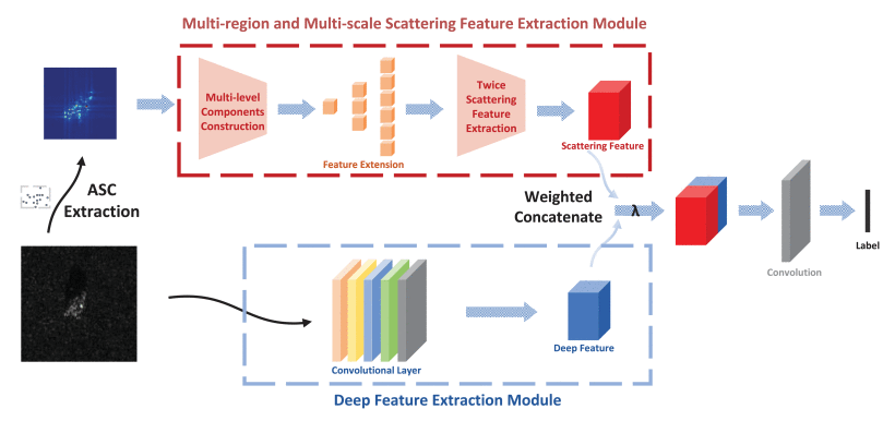
Overall framework of multiregion multiscale scattering feature and deep feature fusion learning framework.

 Z. Liu, L. Wang, Z. Wen, K. Li and Q. Pan, "Multilevel Scattering Center and Deep Feature Fusion Learning Framework for SAR Target Recognition," in IEEE Transactions on Geoscience and Remote Sensing, vol. 60, pp. 1-14, 2022, Art no. 5227914, doi: 10.1109/TGRS.2022.3174703.

Abstract: In synthetic aperture radar (SAR) automatic target recognition (ATR), there are mainly two types of methods: the physics-driven model and the data-driven network. The physics-driven model can exploit electromagnetic theory to obtain physical properties, while the data-driven network will extract deep discriminant features of targets. These two types of features represent the target characteristics in the scattering domain and the image domain, respectively. However, the representation discrepancy caused by the different modalities between them hinders the further comprehensive utilization and fusion of both features.

In order to take full advantage of physical knowledge and deep discriminant feature for SAR ATR, we propose a new feature fusion learning framework SDF-Net to combine scattering and deep image features. In this work, we treat the attributed scattering centers (ASC) as set-data instead of multiple individual points, which can well mine the topological interaction among scatterers. Then, multiregion multiscale subsets are constructed at both component and target levels. To be specific, the most significant scattering intensity and overall representation in these subsets are exploited successively to learn permutation-invariant scattering features according to a set-oriented deep network. 

The scattering representations can provide mid-level semantic and structural features that are subsequently fused with the complementary deep image features to yield an end-to-end high-level feature learning framework, which helps enhance the generalization ability of networks especially under complex observation conditions. 

Extensive experiments on the Moving and Stationary Target Acquisition and Recognition database verify the effectiveness and robustness of the SDF-Net compared against both typical SAR ATR networks and ASC-based models.

URL: https://ieeexplore.ieee.org/stamp/stamp.jsp?tp=&arnumber=9773339&isnumber=9633014

pubmed.ncbi.nlm.nih.gov

Attributed scattering centers for SAR ATR - PubMed

L C Potter  1 , R L Moses

Attributed scattering centers for SAR ATR

L C Potter et al. IEEE Trans Image Process. 1997.

Abstract

High-frequency radar measurements of man-made targets are dominated by returns from isolated scattering centers, such as corners and flat plates. Characterizing the features of these scattering centers provides a parsimonious, physically relevant signal representation for use in automatic target recognition (ATR). In this paper, we present a framework for feature extraction predicated on parametric models for the radar returns. The models are motivated by the scattering behaviour predicted by the geometrical theory of diffraction. For each scattering center, statistically robust estimation of model parameters provides high-resolution attributes including location, geometry, and polarization response. We present statistical analysis of the scattering model to describe feature uncertainty, and we provide a least-squares algorithm for feature estimation. We survey existing algorithms for simplified models, and derive bounds for the error incurred in adopting the simplified models. A model order selection algorithm is given, and an M-ary generalized likelihood ratio test is given for classifying polarimetric responses in spherically invariant random clutter.

Similar articles

Cited by 10 articles

LinkOut - more resources

 https://ieeexplore.ieee.org/document/552098

jpier.org

Target Recognition for Multi-Aspect SAR Images with Fusion Strategies


Two fusion strategies for target recognition using multi-aspect synthetic aperture radar (SAR) images are presented for recognizing ground vehicles in MSTAR database. Due to radar cross-section variability, the ability to discriminate between targets varies greatly with target aspect. Multi-aspect images of a given target are used to support recognition. In this paper, two fusion strategies for target recognition using multi-aspect SAR images are proposed, which are data fusion strategy and decision fusion strategy. The recognition performance sensitivity to the number of images and the aspect separations is analyzed for those two target recognition strategies. The two strategies are also compared with each other in probability of correct classification and operating efficiency. The experimental results indicate that if we have a small number of multi-aspect images of a target and the aspect separations between those images are proper, the probability of correct classification obtained by the two proposed strategies can be advanced significantly compared with that obtained by the method using single image.


1. Mohammadpoor, M., R. S. A. Raja Abdullah, A. Ismail, and A. F. Abas, "A circular synthetic aperture radar for on-the-ground object detection," Progress In Electromagnetics Research, Vol. 122, 269-292, 2012.

2. Ross, T., S. Worrell, V. Velten, J. Mossing, and M. Bryant, "Standard SAR ATR evaluation experiments using the MSTAR public release data set," Proc. SPIE, Vol. 3370, 566-573, 1998.

3. Zhou, J., Z. Shi, X. Cheng, and Q. Fu, "Automatic target recognition of SAR images based on global scattering center model," IEEE Trans. on Geoscience and Remote Sensing, Vol. 49, No. 10, 3713-3729, 2011.

4. Sandirasegaram, N. and R. Englisth, "Comparative analysis of feature extraction (2D FFT and wavelet) and classification (Lp metric distances, MLP NN, and HNeT) algorithms for SAR imagery," Proc. SPIE, Vol. 5808, 314-325, 2005.

5. Nilubol, C. and Q. H. Pham, "Translational and rotational invariant hidden Markov model for automatic target recognition," Proc. SPIE, Vol. 3374, 179-185, 1998.

6. O'Sullivan, J. A., M. D. DeVore, V. Kedia, and M. I. Miller, "SAR ATR performance using a conditionally Gaussian model," IEEE Trans. on Aerospace and Electronic Systems, Vol. 37, No. 1, 91-108, 2001.

7. Brown, M. Z., "Analysis of multiple-view Bayesian classification for SAR ATR," Proc. SPIE, Vol. 5095, 265-274, 2003.

8. Brendel, G. and L. Horowitz, "Benefits of aspect diversity for SAR ATR: Fundamental and experimental results," Proc. SPIE, Vol. 4053, 567-578, 2000.

9. Bhanu, B. and G. Jones, "Exploiting azimuthal variance of scatterers for multiple look SAR recognition," Proc. SPIE, Vol. 4727, 290-298, 2002.

10. Ettinger, G. and W. Snyder, "Model-based fusion of multi-look SAR for ATR," Proc. SPIE, Vol. 4727, 277-289, 2002.

11. Snyder, W. and G. Ettinger, "Performance models for hypothesis-level fusion of multi-look SAR ATR," Proc. SPIE, Vol. 5095, 396-407, 2003.

12. Vespe, M., C. Baker, and H. Griffiths, "Aspect dependent drivers for multi-perspective target classification," IEEE Conference on Radar, 256-260, 2006.

13. Anagnostopoulos, G. C., "SVM-based target recognition from synthetic aperture radar images using target region outline descriptors," Nonlinear Analysis, Vol. 71, e2934-e2939, 2009.

14. Wang, B., Y. Huang, J. Yang, and J. Wu, "A feature extraction method for synthetic aperture radar (SAR) automatic target recognition based on maximum interclass distance," Sci. China Tech. Sci., Vol. 54, 2520-2524, 2011.

15. Liu, M., Y. Wu, P. Zhang, Q. Zhang, Y. Li, and M. Li, "SAR target configuration recognition using locality preserving property and Gaussian mixture distribution," IEEE Trans. on Geoscience and Remote Sensing Letters, Vol. 10, No. 2, 268-272, 2012.

16. Park, J., S. Park, and K. Kim, "New discrimination features for SAR automatic target recognition," IEEE Geoscience and Remote Sensing Letters, Vol. PP, No. 99, 1-5, 2012.

17. Chang, Y.-L., C.-Y. Chiang, and K.-S. Chen, "SAR image simulation with application to target recognition," Progress In Electromagnetics Research, Vol. 119, 35-57, 2011.

18. Zhao, Q., J. C. Principe, V. L. Brennan, D. Xu, and Z. Wang, "Synthetic aperture radar automatic target recognition with three strategies of learning and representation," Opt. Eng., Vol. 39, No. 5, 1230-1244, 2000.

19. Zhao, Q. and J. C. Principe, "Support vector machines for SAR automatic target recognition," IEEE Trans. on Aerospace and Electronic Systems, Vol. 37, No. 2, 643-654, 2001.

20. Yang, W., Y. Liu, G.-S. Xia, and X. Xu, "Statistical mid-level features for building-up area extraction from high-resolution PolSAR imagery," Progress In Electromagnetics Research, Vol. 132, 233-254, 2012.

21. Vapnik, V. N., "An overview of statistical learning theory," IEEE Trans. on Neural Networks, Vol. 10, No. 5, 988-999, 1999.

22. Hsu, C. W. and C. J. Lin, "A comparison of methods for multiclass support vector machines," IEEE Trans. on Neural Networks, Vol. 13, No. 2, 415-425, 2002.

23. Huan, R. and Y. Pan, "Decision fusion strategies for SAR image target recognition," IET Radar, Sonar and Navigation, Vol. 5, No. 7, 747-755, 2011.

24. Huan, R. and R. Yang, "SAR automatic target recognition based on decision fusion," 7th European Conference on Synthetic Aperture Radar (EUSAR), 1-4, 2008.

25. Huan, R., K. Mao, Y. Lei, J. Yu, and M. Xia, "SAR target recognition with data fusion," 2010 WASE International Conference on Information Engineering, Vol. 2, 19-23, 2010.

26. Rizvi, S. A. and N. M. Nasrabadi, "Fusion of automatic target recognition algorithms," Proc. SPIE, Vol. 4726, 122-132, 2002.

27. Rizvi, S. A. and N. M. Nasrabadi, "Fusion techniques for automatic target recognition," Proc. IEEE Conf. Applied Imagery Pattern Recognition Workshop, 27-32, Washingdon DC, USA, 2003.


Sunday, June 5, 2022

[2206.00520] Deep Learning Opacity in Scientific Discovery

[2206.00520] Deep Learning Opacity in Scientific Discovery: 

Deep Learning Opacity in Scientific Discovery Eamon Duede Philosophers have recently focused on critical, epistemological challenges that arise from the opacity of deep neural networks. One might conclude from this literature that doing good science with opaque models is exceptionally challenging, if not impossible. Yet, this is hard to square with the recent boom in optimism for AI in science alongside a flood of recent scientific breakthroughs driven by AI methods. 

In this paper, I argue that the disconnect between philosophical pessimism and scientific optimism is driven by a failure to examine how AI is actually used in science. I show that, in order to understand the epistemic justification for AI-powered breakthroughs, philosophers must examine the role played by deep learning as part of a wider process of discovery. The philosophical distinction between the 'context of discovery' and the 'context of justification' is helpful in this regard.

I demonstrate the importance of attending to this distinction with two cases drawn from the scientific literature, and show that epistemic opacity need not diminish AI's capacity to lead scientists to significant and justifiable breakthroughs. 

Discussion

What I hope to have shown in this paper is that, despite their epistemic opacity, deep learning models can be used quite effectively in science, not just for pragmatic ends but for genuine discovery and deeper theoretical understanding, as well.  This can be accomplished when DLMs are used as guides for exploring promising avenues of pursuit in thecontext of discovery.  

In science, we want to make the best conjectures and pose the besthypotheses that we can.  The history of science is replete with efforts to develop processes for arriving at promising ideas.  For instance, thought experiments are cognitive devices for  hypothesis  generation,  exploration,  and  theory  selection.   In  general,  we  want  our processes of discovery to be as reliable or trustworthy as possible.  But, here, inductive considerations are, perhaps, sufficient to establish reliability.  After all, the processes by which we arrive at our conjectures and hypotheses do not typically serve also to justify them.  

While philosophers are right to raise epistemological concerns about neural net-work opacity, these problems primarily concern the treatment and use of deep learning outputs as findings in their own right that stand, as such, in need of justification which (as  of  now)  only  network  transparency  can  provide.   Yet,  when  DLMs  serve  the  more modest  (though  no  less  impactful)  role  of  guiding  science  in  the  context  of  discovery,their capacity to lead scientists to significant breakthroughs is in no way diminished.

Comments: 12 pages, 1 figure
Subjects: Artificial Intelligence (cs.AI); Computers and Society (cs.CY); Machine Learning (cs.LG); Physics and Society (physics.soc-ph)
Cite as: arXiv:2206.00520 [cs.AI]
  (or arXiv:2206.00520v1 [cs.AI] for this version)
  https://doi.org/10.48550/arXiv.2206.00520


Saturday, June 4, 2022

Applied Sciences | Free Full-Text | Multi-UAV Cooperative Anti-Submarine Search Based on a Rule-Driven MAC Scheme

Applied Sciences | Free Full-Text | Multi-UAV Cooperative Anti-Submarine Search Based on a Rule-Driven MAC Scheme

This is an early access version, the complete PDF, HTML, and XML versions will be available soon.

Article

Multi-UAV Cooperative Anti-Submarine Search Based on a Rule-Driven MAC Scheme

by 1, 1 and 2,*
1College of Marine Electrical Engineering, Dalian Maritime University, Dalian 116000, China
2College of Mechanical and Electrical Engineering, Dalian Minzu University, Dalian 116000, China
*Author to whom correspondence should be addressed.
Academic Editor: Seong-Ik Han
Appl. Sci. 2022, 12(11), 5707; https://doi.org/10.3390/app12115707
Received: 13 May 2022 / Revised: 28 May 2022 / Accepted: 31 May 2022 / Published: 3 June 2022
(This article belongs to the Section Aerospace Science and Engineering)
In order to enhance the anti-submarine capability of multi-unmanned aerial vehicles (multi-UAVs) in the unknown sea environment and improve the search efficiency, in this paper, we propose a rule-inspired-multi-ant colony (RI-MAC)-based UAV cooperative search algorithm. First, a special sea area anti-submarine search model is established, including an association rule-driven target probability map (TPM) model, a UAV kinematics model, and a sensor model. The novel model has the characteristics of rule linkage, which effectively improves the accuracy of target detection probability in unknown environments. Secondly, according to the established search model, a multi-objective utility function based on association rules is derived. In order to solve the problem of multi-objective optimization, an RI-MAC algorithm based on association rules is proposed, and a pheromone update method using threat avoidance is designed to optimize the search path of multi-UAVs. Finally, a simulation experiment is conducted to verify the effectiveness and superiority of the proposed search algorithm.


Tuesday, May 10, 2022

Satellite Ground Segment as a Service (GSaaS) driven by New Space requirements – International Defense Security & Technology Inc.

Satellite Ground Segment as a Service (GSaaS) driven by New Space requirements – International Defense Security & Technology Inc.

byRajesh Uppal Create rule

GAAS.jpg


The artificial satellite system has three operational components space segment,  user and ground segments). Space segment comprises the satellite or satellite constellation and the uplink and downlink satellite links. A ground segment consists of all the ground-based elements of a spacecraft system used by operators and support personnel.

The ground segment enables management of a spacecraft, and distribution of payload data and telemetry among interested parties on the ground. The primary elements of a ground segment are Ground (or Earth) stations, which provide radio interfaces with spacecraft; Mission control (or operations) centers, from which spacecraft are managed; Ground networks, which connect the other ground elements to one another; Remote terminals, used by support personnel; Spacecraft integration and test facilities and Launch facilities.

Ground Stations

In order to communicate with satellites, ground stations are necessary. Located in various parts of the world, they support different types of satellites, depending on their inclination and orbit. For example, polar orbiting satellites need to connect with ground stations in the poles (e.g. Inuvik or Kiruna in the North Pole and Punta Arenas or Dongara in the South Pole), which provides rather long duration passes, enabling increased amount of data downloaded.

The ground stations are made of one or more antennas, that enable satellite operators to communicate with the satellite, sending telecommands and downlinking telemetries (e.g. mission data, satellite status). This communication is performed all along satellite lifecycle, from Launch and Early Orbit Phase (LEOP), going through commissioning, routine and critical operations, up to satellite end-of-life and decommissioning.

Ground Segment value chain

In order to ensure such operations, a typical GS entails various infrastructure and activities that can be depicted using a value chain, made of three main blocks: upstream, midstream and downstream.

The three blocks are detailed as the following:
– The upstream involves all the hardware and software components that enable mission operations. It encompasses ground stations (e.g. antennas, modems, radio, etc.) construction and maintenance, development of data systems (for ground station control, spacecraft control, mission planning and scheduling, flight dynamics, etc.), and the ground
networks (i.e. infrastructure necessary to ensure connectivity among all operations GS elements),
– The midstream is composed of all activities that support mission operation. More specifically, it encompasses the operation of the ground stations, performs spacecraft and payload Telemetry Tracking and Control (TT&C), and the signal downlinking and data retrieving,
– The downstream encompasses all activities performed once the data is retrieved on Earth, that include data storage, pre-processing (e.g. error corrections, timestamps, etc.), and all services based on data analytics.

GS activities require investment and time

In order to perform ground segment activities, significant investment and efforts are required to build and maintain a dedicated ground segment, but also to deal with licensing issues. On the one hand, building, operating and maintaining a ground segment is an expensive endeavour that requires many resources including ground stations (i.e. antennas, modems, land) and dedicated personnel with specific skills. Building ground stations is particularly costly for high-frequency bands (requiring more expensive antennas) or satellites in Low Earth Orbit (LEO).

Indeed, satellite operators having satellites in LEO usually require a global network of ground stations installed in multiple countries, in order to download data when and where they need it without having to wait for the satellite to pass over a desired location. In addition, investments in specific infrastructure (i.e. servers, networks and power) are required to process, store, and ensure transport data. In the end, the cost of ground segment over the entire satellite lifecycle can reach one third of the total cost for large programmes and can represent between 10 and 15% of satellite operators’ OPEX, according to industry experts. Consequently, such important expenses can make it difficult for satellite operators to invest in a wholly dedicated network.

On the other hand, building a dedicated ground segment involves dealing with important regulatory constraints, especially to get licensing for both space and ground segments. Licensing is key to ensure that Radio Frequency (RF) interferences do not negatively impact satellite operators. Indeed, satellite signals can be overridden by a rogue or unlicensed system, which can jeopardize satellite operators’ activities and business. In order to ensure such situation does not happen, licensing procedures are inherently demanding. Satellite operators not only have to deal with licensing of the space segment from the International Telecommunication Union (ITU) – in charge of spectrum assignment – but also to deal with licensing for the ground segment with the country in which they want to build and operate their ground station.

Considering all the efforts required to ensure ground segment activities, satellite operators have already been outsourcing their activities to GS experts like SSC or KSAT for decades. Over time, these GS service providers have developed large networks of ground stations across the world, including in harsh environments, such as polar areas. These networks enabled them to offer comprehensive services to a wide variety of customers – whatever their satellite inclination, orbit (e.g. polar, LEO, GEO, etc.) or mission type.

GS providers could support their customers all along the mission lifetime (e.g. routine, LEOP, decommissioning), providing support not only for TT&C and data acquisition services in various bands, but also for many other services spanning hosting and maintenance services (i.e. install, operate and maintain a ground station on behalf of a satellite operator), licensing support (for space and ground segment), and data handling. GS service providers would thus provide their customers with a “top assurance level” offer. In exchange, satellite operators would agree to commit for various years, and pay relatively high price.

New Space requirements for Ground stations

Space is becoming more dynamic than ever with mega-constellations, multi-orbit satellites, and software-defined payloads. The world’s demand for broadband connectivity has created a new generation of high-throughput satellites in geosynchronous Earth orbit (GEO), medium Earth orbit (MEO), and now low Earth orbit (LEO).

The pace of technological change has led some to question whether the ground segment can keep up and avoid becoming the bottleneck between innovations in space and terrestrial networks including 5G. This is particularly important given the technological shift from the world of Geostationary Orbit (GEO)  to a Low-Earth Orbit (LEO) and Medium-Earth Orbit (MEO) world, where satellite’s relative motion throw up additional challenges.

The New Space non-GEO constellations — in Low- or Medium-Earth orbit (LEO or MEO) — move across the sky, requiring multiple ground stations across the globe to stay in touch. “All these new constellations, these enormous numbers of new space vehicles, all need ground stations to service them, stay in contact, provide direct-to-Earth communications,” says John Heskett, the chief technology officer at Kongsberg Satellite Services ( KSAT).

And it’s not just the orbits. The new services that non-GEO constellations are getting into — like low latency communications, ubiquitous Internet of Things (IoT) connectivity, or near real-time Earth Observation (EO) — also require globally dispersed ground stations, so that data can be downloaded in real-time.

In the new multi-orbit world, says Carl Novello, CTO of NXT Communications Corp. (NXTCOMM), an Atlanta, Georgia area-based startup, the biggest challenge on the ground will be flexibility. Traditionally satellite operators have been tightly vertically integrated, with terminals designed to work with a single constellation across a relatively narrow portion of the spectrum. With operators adopting a multi-orbit approach, that increasingly won’t cut it.

“The challenge is how do you move from being a product that is relatively fit for a single purpose to becoming the Swiss Army knife of antennas?” Novello asks. “One that will work in GEO use cases and LEO use cases and MEO use cases, with different requirements for frequency bands, uplink power, different regulatory requirements to meet, and so on.” In other words, concludes Novello, “How do we build a better antenna fit for this brave new world of satellite connectivity?”

But advancements in technology are shifting the ground system from purpose-built, proprietary hardware architectures to software-defined, cloud-centric, and extensible virtual platforms that support multiple satellites, payloads and orbits on demand. This is being enabled by a series of innovations in antenna technology, waveform processing and system design, quietly starting a “New Ground” revolution down on Earth, as well.

NSR, a market research and consulting firm, estimates that cumulative revenues for the entire ground segment through 2028 will total $145 billion. The market will generate $14.4 billion annually by 2028, the firm states in its recent report, Commercial Satellite Ground Segment, 4th Edition (CSGS4). The user terminal will command a substantial portion of this spend.

Ground Segment as a Service

With New Space, the needs of satellite operators evolved: missions were shorter, satellite development time was dramatically reduced, and the budget dedicated to GS was much smaller. The GS services offered by  incumbents were thus not adapted, deemed too complicated (notably because of international standards) and costly.

But most startups don’t have the resources or the time to build out their own ground segment, explains Heskett. “These startups are on a very tight runway. They have six months to a year from the time they get their VC funding until they have to put something on a rocket,” he says. Even if they could afford to build out their own ground station network, they wouldn’t have the time to prototype, test, and integrate the technology.

In order to fill in the gap between supply and demand, new GS services providers entered market, with the objective to offer New Space satellite operators a simple, elastic and cost-effective way to communicate with their satellite: GSaaS was born

The model  “as a Service” (aaS) initially stems from the IT industry, and more specifically from cloud computing. Software as a Service (SaaS) is a well-known example of “aaS” model, where infrastructure and hard, middle and software are handled by cloud service providers and made available to customers over the Internet, on a “pay as-you-go” basis. “aaS” offers various benefits to the customers, as it helps them minimize upfront investment while avoiding operation, maintenance, and other ownership costs.

Customers can thus transform their capital expenditure (CAPEX) into operational expenditure (OPEX).  Instead, they can choose the paying scheme that suits their needs the best, opting either for “pay as you use” or subscribing on a monthly/annually-basis.

Borrowing concepts and methods of IaaS and cloud computing, GSaaS abstracts GS infrastructure. To do so, it mutualises GS infrastructure, relying on a single network of ground stations in order to enable satellite operators communicate with their satellites. Thus, GSaaS acts as a lever that enables satellite operators to launch their business faster and to focus on their core business, which is, in essence, the provision of data. Acknowledging these advantages, new users, including public entities, have started expressing interest in utilising this service.

The interface and API are designed to be easy to use, to enable all types of satellite operators (e.g. universities, public and private) control their satellites. The API enables satellite operators to interact with the ground station network, determine their satellite parameters and constraints, retrieve the schedule of operations, as well as all the data collected.

When it comes to satellite mission types, most GSaaS users are EO and Internet of Things (IoT) satellite operators. EO satellites usually need to download as much data as possible and depending on their business, they look for near-real-time images. They however do not necessarily need low latency (i.e. maximum time between satellite data acquisition and reception by the user). For example, Eumetsat EO satellites in LEO have a latency of 30 minutes, which is enough to provide adequate services to their customers.

As compared to EO satellite operators, IoT satellite operator’s priority is more about number of contacts, and they look for low latency (down to 15mn for Astrocast for example). They thus tend to select highly reliable GS that ensure satellite connection in a timely manner.

There are two types of GSaaS customers: the ones that own ground stations, and the ones that do not. The first usually want to use GSaaS to complement their ground station network. They can use it in a punctual manner, to answer to specific events (e.g. LEOP, catastrophes, etc.), as backup ground stations (e.g. in case of a problem on one of their ground stations), or to download more data. This is for example the case of Spire Global Inc. that uses AWS Ground Station to satisfy growing demand by flexibly enlarging their ground network capabilities.

The second almost entirely rely on GSaaS to communicate with their satellites. They sometimes partner with various GSaaS providers to guarantee continuity of service (e.g. Astrocast using both KSAT and Leaf Space GSaaS services).

The need for GSaaS also depends on the orbit type. Indeed, as compared to GEO satellite operators that usually need few ground stations. located in their targeted region to perform their mission, LEO satellite operators look for a global coverage. Indeed, as satellites move around the Earth, they need to be able to connect with ground station in different parts of the world. However, in order to offer lower latencies, more ground stations are necessary, which can be a major hindrance. For this reason, so far, a large majority of GSaaS customers are LEO satellite operators.

Ground station as a service suppliers

Many classes of GS service suppliers now exist.  Some are new actors that includes new start-ups (e.g. Leaf Space, Infostellar, RBC Signals, Atlas Space Operations, etc.), IT-born companies (e.g. AWS) but also GS incumbents (e.g. SSC, KSAT). Building upon their experience in satellite operation and leveraging their global network of ground stations, GS providers incumbents designed solutions specifically adapted to small satellite operators and large constellations with SSC Infinity and KSATlite for example. ”

To do so, incumbents standardised their ground station equipment and configurations, and developed web based and API customer interfaces, notably to enable pass scheduling.

As such, commercial EO satellite operators with a focus on investing capital in the space segment for launch and manufacture, have an additional path to a partially/fully outsourced ground service model that leverages the technological capabilities and financial strategies of the Cloud era. A satellite operator subject to demand uncertainties will find the scheduled contact via the pay-per-minute pricing means spending less capital compared to procuring ground station antennas priced in the millions.

With on-demand measurability and flexibility in spinning up of services, Cloud-based solutions provide a shift from the traditionally CAPEX-heavy investments of satellite ground infrastructure to a reduced OPEX consideration that is flexible and open. In the case of AWS Ground Station, the service is aimed at offering flexible per-minute access to antennas across eight locations for self-service scheduling. This in turn alleviates the customer’s need to buy, lease, build or manage a fully owned ground segment.

By reducing need for ownership of hardware/software, such solutions also allow satellite players to cooperate with Cloud service providers(CSPs) and deploy their applications/serve their customers with great efficiency. Cloud-enabled ground systems will be a key enabler in opening up the revenue opportunity here across verticals and regions, as technology rises to meet and innovate on the supply of satellite data. With expanded and flexible Cloud Computing capacity close to the processing node, insight extraction is also local to end users, thereby also alleviating unnecessary Cloud costs.

Azure Orbital

After Amazon, Microsoft now getting into ground station as a service business with Azure Orbital. In September 2021, the software giant announced a preview of the business that enables satellite operators to communicate to and control their satellites, process data, and scale operations with Microsoft Azure Cloud.

“We are extending Azure from under the sea to outer space. With Azure Orbital, we are now taking our infrastructure to space, enabling anyone to access satellite data and capabilities from Azure,” Microsoft CEO Satya Nadella announced during his opening keynote at the Microsoft Ignite 2020 conference.

With Azure Orbital, the ground segment, including the ground stations, network, and procedures, becomes a digital platform now integrated into Azure and complemented by partners such as Amergint, Kratos, KSAT, Kubos, Viasat and US Electrodynamics Inc.

“Microsoft is well-positioned to support customer needs in gathering, transporting, and processing of geospatial data. With our intelligent Cloud and edge strategy currently extending over 60 announced cloud regions, advanced analytics, and AI capabilities coupled with one of the fastest and most resilient networks in the world — security and innovation are at the core of everything we do,” Yves Pitsch Principal Program Manager, Azure Networking, wrote in a blog post.

We are thrilled that we will be co-locating, deploying and operating our next-generation O3b mPOWER gateways alongside Microsoft’s data centers. This one-hop connectivity to the cloud from remote sites will enable our MEO customers to enhance their cloud application performance, optimize business operations with much flexibility and agility needed to expand new markets,” Hemingway added.

Earlier in August, Microsoft had filed documents with the Federal Communications Commission outlining its intent to build a network of ground stations and connecting satellite operators to its Azure cloud. On September 2, the FCC authorized Microsoft to perform proof-of-concept demonstrations of the service, which comes with a six-month license allowing for data downloads from Urthecast’s Deimos-2 Earth observation satellite.

Azure Orbital is a fully managed cloud-based ground station as a service that lets you communicate with your spacecraft or satellite constellations, downlink and uplink data, process your data in the cloud, chain services with Azure services in unique scenarios, and generate products for your customers. Azure Orbital lets you focus on the mission and product data by off-loading the responsibility for deployment and maintenance of ground station assets. This system is built on top of the Azure global infrastructure and low-latency global fiber network.

https://www.youtube.com/watch?v=GeyQtOGixLA

References and Resources also include:

http://interactive.satellitetoday.com/via/november-2021/renting-the-ground-the-growing-future-of-ground-segment-as-a-service/

https://www.researchgate.net/publication/345765418_Market_perspectives_of_Ground_Segment_as_a_Service


Light's Topology Shrugs Off Turbulence

Scientists Transmit Data via Magnetic Skyrmions in Laser Beams with 98% Fidelity Over Hundreds of Meters A laser beam scrambled beyond rec...