Thursday, March 20, 2025

NASA Deploys Advanced Radar Technology to Track California's Groundwater


NASA Deploys Advanced Radar Technology to Track California's Groundwater

In a groundbreaking initiative that could transform water management in drought-prone regions, NASA has begun using sophisticated radar technology to track the invisible journey of groundwater beneath California's San Joaquin Valley.

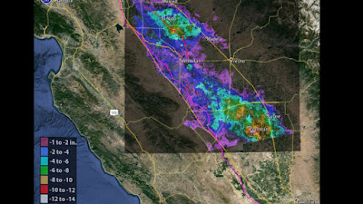
The space agency's Uninhabited Aerial Vehicle Synthetic Aperture Radar (UAVSAR), mounted on a specially equipped aircraft, completed its first flight over the Tulare Basin in late February. This marks the first of six planned missions in 2025 designed to map how and where Sierra Nevada snowmelt replenishes the region's depleted aquifers.

"NASA's technology has the potential to give us unprecedented precision in measuring where snowmelt is recharging groundwater," said Erin Urquhart, program manager for NASA's Earth Action Water Resources program. "This information is vital for farmers, water managers, and policymakers trying to make the best possible decisions to protect water supplies for agriculture and communities."

Detecting the Invisible

What makes this technology remarkable is its ability to detect surface movements smaller than a centimeter – movements that occur as water pressure slightly pushes up the ground above. These minute "surface bulges" create what Stanford University geophysicist Rosemary Knight calls an "InSAR recharge signature."

"For generations, we've been managing water in California without truly knowing where that meltwater seeps underground and replenishes groundwater," said Knight, who leads the research project.

The UAVSAR doesn't directly observe water but instead measures these tiny elevation changes, providing researchers with critical data about the paths water takes as it moves from the Sierra Nevada mountains into the valley's aquifers.

Critical for Agriculture

The stakes couldn't be higher for California's San Joaquin Valley, which produces over a third of America's vegetables and two-thirds of its fruits and nuts. Most farming operations in the region rely heavily on groundwater, especially during drought years.

"Knowing where recharge is happening is vital for smart water management," explained Aaron Fukuda, general manager of the Tulare Irrigation District. "In dry years, when we get limited opportunities, we can direct flood releases to areas that recharge efficiently. In wetter years, it's even more crucial—we need to move water into the ground as quickly as possible to prevent flooding and maximize the amount absorbed."

Part of a Broader Water Monitoring Strategy

The UAVSAR flights complement NASA's broader suite of water monitoring technologies, including the upcoming NISAR (NASA-ISRO Synthetic Aperture Radar) mission, a joint project with the Indian Space Research Organization set to launch soon. NISAR will provide global-scale radar data every 12 days.

NASA's Gravity Recovery and Climate Experiment (GRACE) satellites have already revealed major declines in aquifers across California's Central Valley, though at a coarser resolution than what the new airborne radar can achieve.

"Airborne campaigns like this one in the San Joaquin test how our technology can deliver tangible benefits to American communities," said Stephanie Granger, director of NASA's Western Water Applications Office. "We partner with local water managers to evaluate tools that have the potential to strengthen water supplies across the Western United States."

As climate change continues to alter precipitation patterns and increase drought severity in the American West, these innovative technologies may prove essential for sustainable management of the region's most precious resource: water.

NASA's Uninhabited Aerial Vehicle Synthetic Aperture Radar (UAVSAR) has been instrumental in monitoring groundwater-related land subsidence in California. By utilizing Interferometric Synthetic Aperture Radar (InSAR) techniques, UAVSAR detects minute changes in ground elevation, which are often indicative of groundwater extraction and recharge activities.

Key Applications of UAVSAR in California:

  1. Monitoring the California Aqueduct:

  2. Assessing Subsidence in the San Joaquin Valley:

  3. Evaluating Groundwater Management Efforts:

    • The California Department of Water Resources (DWR) utilizes UAVSAR data to inform groundwater management strategies. The data aids in understanding subsidence patterns, which is crucial for maintaining infrastructure integrity and implementing effective water management policies. 

These applications underscore UAVSAR's vital role in detecting and tracking groundwater-induced land subsidence, thereby supporting sustainable groundwater management and infrastructure protection in California.


NASA's Uninhabited Aerial Vehicle Synthetic Aperture Radar (UAVSAR) 

NASA's Uninhabited Aerial Vehicle Synthetic Aperture Radar (UAVSAR) is an advanced radar imaging system designed to monitor environmental changes, natural hazards, and Earth's surface movements. It is mounted on a Gulfstream-III (G-III) aircraft, which serves as a stable platform for high-resolution radar observations.

Key Features of UAVSAR:

  • L-band Synthetic Aperture Radar (SAR): UAVSAR operates in the L-band (1.26 GHz), allowing it to penetrate vegetation, soil, and even ice, providing detailed subsurface imaging.
  • Interferometry Capabilities: It can measure ground deformation, such as earthquake-induced shifts, landslides, and glacier movements, with millimeter-level precision.
  • Repeat-Pass Imaging: The Gulfstream-III follows precisely the same flight path on multiple occasions, allowing for interferometric SAR (InSAR) comparisons over time.
  • Polarimetric Radar Imaging: It captures data in multiple polarizations, enhancing the ability to distinguish between different surface materials and vegetation types.

Gulfstream-III as a UAVSAR Platform

  • The G-III jet (tail number N536NA) is a business-class aircraft modified to carry UAVSAR in a pod under its fuselage.
  • It flies at an altitude of 41,000 feet (12.5 km) with a speed of about 450 knots (833 km/h), making it ideal for consistent, high-quality radar data collection.
  • The aircraft's stability and ability to fly precise repeat paths make it perfect for interferometric studies.

Scientific and Operational Applications

  1. Earthquake and Tectonic Studies: UAVSAR has been used to monitor fault lines, such as the San Andreas Fault, and assess land deformation after seismic events.
  2. Flood and Disaster Response: It helps map flooded regions, aiding agencies like FEMA in disaster assessment.
  3. Glaciology: UAVSAR tracks ice sheet movement in Antarctica and Greenland to understand climate change impacts.
  4. Forestry and Vegetation Monitoring: By using polarimetric radar, it helps assess forest health, biomass, and deforestation patterns.
  5. Oil Spill and Coastal Studies: UAVSAR can detect oil spills and assess coastal erosion.
  6. Volcanology: It tracks volcanic deformation to help predict eruptions.

This system has been in operation for over a decade and continues to provide critical data for scientific research, environmental monitoring, and disaster response efforts worldwide.

SOURCES

Here are some authoritative sources providing detailed information on NASA's Uninhabited Aerial Vehicle Synthetic Aperture Radar (UAVSAR) system mounted on a Gulfstream-III (G-III) jet:

  1. NASA's Johnson Space Center (JSC) Gulfstream G-III Overview

  2. NASA Airborne Science Program: Gulfstream III - JSC

  3. NASA's Jet Propulsion Laboratory (JPL) UAVSAR Mission Page

  4. NASA Armstrong Flight Research Center's C-20A Aircraft

  5. NASA's Airborne Science Program: UAVSAR

NASA uses advanced radar to track groundwater in California

Chinese UAVs Increasingly Active in Taiwan and Japan's Airspace

image of the Wing Loong-10 UAV captured by the P-3C Orion maritime patrol aircraft. (Image credit: Taiwan’s Military News Agency

Chinese UAVs Increasingly Active in Taiwan and Japan's Airspace

Taiwan and Japan have recently documented the growing presence of advanced Chinese unmanned aerial vehicles (UAVs) in the region, marking a significant escalation in China's aerial surveillance and potential strike capabilities around disputed territories.

Taiwan's military has captured the first confirmed images of China's Wing Loong-2 and Wing Loong-10 drones during recent military drills around the island. The Republic of China Air Force (RoCAF) released footage of these UAVs taken through the electro-optical systems of their F-16V fighters and P-3C Orion maritime surveillance aircraft.

The interceptions occurred as China conducted massive naval and aerial exercises around Taiwan between March 17-18, with Taiwan's Ministry of National Defense tracking 59 Chinese aircraft and nine naval vessels. Of these aircraft, 43 crossed the Taiwan Strait's Median Line and entered Taiwan's Air Defense Identification Zone (ADIZ).

"This marks the first time these specific drone models have been both explicitly identified and photographed by Taiwanese forces, though Chinese military drones have been observed in the region before," a military analyst noted.

Japan's Air Self-Defense Force also reported intercepting a Wing Loong-10 drone over the East China Sea north of Okinawa on May 27. The drone was observed heading eastward from mainland China before reversing course without violating Japanese airspace.

The Wing Loong-10, also known as Wuzhen-10 or WZ-10, is a high-altitude, long-endurance (HALE) unmanned combat aerial vehicle developed by the Chengdu Aircraft Industry Group. First introduced in 2016, it features dual turbofan engines and has been photographed with various air-to-ground munitions and electronic warfare capabilities.

The Wing Loong-2, described by Taiwan's Military News Agency as a "Type 2 Attack UAV," is a medium-altitude, long-endurance drone capable of both surveillance and strike operations.

Military experts suggest these drone deployments represent China's growing capability to conduct comprehensive surveillance and potential strike operations throughout the region without risking pilot lives, while simultaneously testing Taiwan's air defense responses and gathering intelligence on military installations.

The increased UAV activity coincides with heightened diplomatic tensions, particularly following Taiwan President Lai Ching-te's statement characterizing China as a "hostile" foreign entity, and the G7's criticism of China's actions in disputed territories.

SIDEBAR: China's Advanced UAV Arsenal

Wing Loong-10 (Wuzhen-10)

Classification: High-Altitude Long-Endurance (HALE) Unmanned Combat Aerial Vehicle Developer: Chengdu Aircraft Industry Group Introduction: 2016 Key Features:

  • Twin turbofan engines (in "Wind Shadow" variant)
  • Single-engine configuration also available ("Cloud Shadow" variant)
  • Capable of extended operations over vast distances
  • Equipped with ventral EO/IR (Electro-Optical/Infrared) turret
  • Can carry various air-to-ground munitions
  • EW/ELINT (Electronic Warfare/Electronic Intelligence) payload capability
  • Canted vertical stabilizers with concealed exhaust design enhancing stealth characteristics
  • Previously detected operating in the East China Sea in May 2024

Wing Loong-2 (GJ-2)

Classification: Medium-Altitude Long-Endurance (MALE) Unmanned Aerial Vehicle Service Entry: 2018 Capabilities:

  • Dual-role platform for both intelligence gathering and strike operations
  • Six underwing hardpoints for weapons
  • Three blade antennas (one under each wing, one under fuselage) for signals intelligence
  • Testbed for new technologies and systems
  • Advanced reconnaissance sensors
  • Export success with users including Egypt, Morocco, Nigeria, Saudi Arabia, and UAE

Strategic Significance

These UAVs provide China with significant advantages in regional surveillance and potential conflict scenarios:

  • Ability to conduct persistent reconnaissance without risking pilot lives
  • Capacity to rapidly deploy strike capabilities if needed
  • Testing Taiwan's air defense response times and procedures
  • Building comprehensive intelligence picture of military installations
  • Demonstrating territorial claims through persistent presence
  • Creating strategic ambiguity through unmanned systems deployment
  • Contributing to China's "grey zone" tactics—military activities that fall short of armed conflict

Sources and Citations

  1. "Taiwan's F-16V, P-3C Capture Footage of China's Wing Loong-2, Wing Loong-10 UAVs"
    The Aviationist
    Author: Parth Satam
    URL: https://theaviationist.com/

  2. "Wing Loong II UAV recorded in Taiwan ADIZ for first time"
    Janes Defense
    Author: Akhil Kadidal
    Date: October 6, 2023
    URL: https://www.janes.com/

  3. "Japan spots China's new spy, strike drone for first time over waters north of Okinawa"
    Stars and Stripes
    Author: Keishi Koja
    Date: May 27, 2024
    URL: https://www.stripes.com/

  4. Taiwan Ministry of National Defense (MND)
    Press releases and official statements regarding Chinese aircraft incursions
    URL: Not specified in the document

  5. Japan Ministry of Defense
    Official statement on Wing Loong-10 interception
    Date: May 27, 2024
    URL: Not specified in the document

  6. AirForce Technology
    Information on Wing Loong-10 specifications
    Date: February 2, 2021
    URL: Not specified in the document

  7. Federation of American Scientists (FAS)
    "Nuclear Notebook: China" report
    Referenced in The Aviationist article
    URL: Not specified in the document

  8. Japan Ministry of Defense
    Annual white paper on Chinese UAV capabilities
    Date: 2023
    URL: Not specified in the document


theaviationist.com

Parth Satam


Wing Loong II UAV recorded in Taiwan ADIZ for first time


stripes.com

Japan spots China’s new spy, strike drone for first time over waters north of Okinawa

Keishi Koja


Wednesday, March 19, 2025

GA-ASI Releases New TacSit-C2 for Payload Command and Control | General Atomics


GA-ASI Advances Unmanned Aircraft Capabilities with New Command and Control Software

March 19, 2025

SAN DIEGO — General Atomics Aeronautical Systems, Inc. (GA-ASI) unveiled its latest innovation in unmanned aircraft technology today with the release of TacSit-C2, an advanced payload command and control software designed to streamline drone operations and reduce manpower requirements.

The new system, part of GA's Quadratix software enterprise, represents the culmination of more than two decades of experience in developing control systems for unmanned aerial vehicles (UAVs). According to company officials, TacSit-C2 will significantly enhance operational capabilities by allowing operators to view and manage multiple sensor feeds simultaneously.

"We've integrated Multiple Intelligence Signal Processing into a single application," explained Darren Moe, GA-ASI's senior director for Automation, Autonomy and Artificial Intelligence. "This includes radar, Electronic Intelligence, Communications Intelligence, and Electro-optical/Infrared sensors all working together seamlessly."

The system's Multi-Mission Controller (MMC) feature represents a major advancement in UAV operations, enabling a single operator to control multiple unmanned vehicles at once—a capability that could dramatically reduce staffing requirements for drone missions.

Industry analysts note that as military and civilian applications for unmanned aircraft continue to expand, the ability to efficiently control these systems becomes increasingly critical. TacSit-C2 appears positioned to address this need with its scalable architecture that can adapt to missions of varying complexity.

The software is designed to run on commercial off-the-shelf hardware, from laptops to servers, making it accessible across a range of operational environments. Additionally, GA-ASI has included a Software Development Kit that will allow third parties to expand the system's capabilities with custom additions.

GA-ASI, widely recognized as a global leader in unmanned aircraft systems, has accumulated over 8 million flight hours with its Predator line of UAVs. The company's systems include the MQ-9A Reaper, MQ-1C Gray Eagle 25M, MQ-20 Avenger, and MQ-9B SkyGuardian/SeaGuardian, which have been deployed in various military and civilian operations worldwide.

The company expects TacSit-C2 to be fully deployed before the end of 2025, potentially setting a new standard for unmanned aircraft control systems in both military and commercial applications.

For defense contractors and military organizations looking to enhance their unmanned capabilities, this latest advancement from GA-ASI offers promising new options for more efficient and effective drone operations.

GA-ASI Releases New TacSit-C2 for Payload Command and Control | General Atomics

Sunday, March 16, 2025

General Atomics Tested Gray Eagle ER UAS Using Proliferated Low Earth Orbit Satellites - The Aviationist

GA-ASI Gray Eagle ER

Gray Eagle UAS Makes Aviation History with PLEO Satellite Integration

By Tech Defense Reporter
March 16, 2025

In a significant advancement for military unmanned aerial technology, General Atomics Aeronautical Systems, Inc. (GA-ASI) has successfully completed the first flight tests of its Gray Eagle Extended Range (GE-ER) unmanned aircraft system using cutting-edge Proliferated Low Earth Orbit (PLEO) satellite communications.

The milestone testing, which began in January 2025 under a U.S. Army contract, positions the Gray Eagle as the first Army aircraft to operate with the new satellite service, marking a revolutionary step forward in battlefield communications and command capabilities.

Breaking New Ground in Military Communications

According to GA-ASI's announcement on March 12, the Gray Eagle now stands as the only U.S. Army unmanned aerial system capable of seamlessly integrating with three distinct satellite constellations: Geostationary Earth Orbit (GEO), Low Earth Orbit (LEO), and the newer PLEO networks. This triple-constellation capability provides unprecedented communication flexibility, enhanced navigation precision, and resilient data management for military operations.

"This represents a quantum leap in battlefield connectivity," said military technology analyst Dr. Sarah Chen. "The ability to switch between satellite constellations provides redundancy that significantly reduces vulnerability to electronic warfare and ensures mission continuity even in contested environments."

Testing Progress and Future Plans

The initial testing phase concentrated on flight-critical operations, with special attention to core aircraft control functions and the integration of sensor and communications systems. To date, GA-ASI has completed two successful GE-ER flights utilizing PLEO connectivity, alongside numerous ground test events.

The company has indicated that more extensive testing is already in planning stages, which will expand operations across the full flight regime to thoroughly validate all operational parameters.

Modular Open Systems Approach: The Key to Rapid Integration

Central to the Gray Eagle's adaptability is its Modular Open Systems Approach (MOSA) design architecture, featuring standardized interfaces and protocols. This forward-thinking design philosophy has enabled the rapid integration of PLEO constellation capabilities without requiring extensive technical modifications or lengthy testing timelines.

Don Cattell, GA-ASI's Vice President of Army Programs, emphasized the importance of this approach: "The PLEO integration and flight testing continue to show that the current GE-ER open architecture is real. We are practicing rapid integration now which will prove critical to the platform's survivability and mission success in Multi-Domain Operations."

The Next Generation: Gray Eagle 25M

Building on the success of the GE-ER, the advanced Gray Eagle 25M (GE 25M) model takes the MOSA concept even further with a government-owned, government-controlled open architecture system. This enhanced design enables plug-and-play capabilities that ensure rapid, low-cost adaptability to emerging threats.

The GE 25M incorporates several significant upgrades, including:

  • A new 200 horsepower Heavy Fuel Engine (HFE 2.0)
  • Advanced, modular datalinks
  • Eagle Eye multi-mode radar with moving target indication
  • AI-ML (Artificial Intelligence-Machine Learning) capabilities
  • Upgraded propulsion system
  • Laptop-based ground control station for improved mobility

Military experts note that PLEO will serve as a baseline capability for the 25M system, providing substantially higher data rates and supporting global flight operations "from pole to pole."

Strategic Implications

The integration of PLEO capabilities represents a critical enhancement to the Gray Eagle platform's survivability in contested environments. When combined with longer-range sensors, anti-jam navigation, and expeditionary ground control systems, the GE 25M can operate safely outside threat weapons envelopes while still delivering effects hundreds of kilometers beyond friendly lines.

Defense analysts suggest this development comes at a crucial time, as near-peer adversaries continue to develop sophisticated anti-access/area denial capabilities designed to limit U.S. military effectiveness.

"What we're seeing with the Gray Eagle PLEO integration is the future of unmanned aerial systems," said retired Air Force Colonel James Harrison. "The ability to leverage multiple satellite constellations provides the kind of resilience and adaptability that will be essential in any future conflict."

With over 8 million flight hours logged across its Predator line of unmanned aircraft systems, GA-ASI continues to demonstrate its leadership in developing long-endurance, multi-mission platforms that deliver persistent situational awareness and rapid strike capabilities for modern warfighters.

General Atomics Tested Gray Eagle ER UAS Using Proliferated Low Earth Orbit Satellites - The Aviationist

About the MQ-1C Gray Eagle ER UAS

The Gray Eagle Extended Range (GE-ER) is an advanced unmanned aircraft system (UAS) developed by General Atomics Aeronautical Systems, Inc. (GA-ASI). It is an upgraded version of the MQ-1C Gray Eagle, designed to provide the U.S. Army with increased endurance, payload capacity, and operational flexibility.

Key Features and Capabilities:

  1. Extended Endurance

    • The GE-ER can fly for 40+ hours, significantly more than its predecessor.
    • This allows for longer reconnaissance, surveillance, and target acquisition (RSTA) missions.
  2. Increased Payload Capacity

    • Can carry multi-mission payloads, including sensors, radars, and weapons.
    • Capable of deploying Hellfire missiles, bombs, and electronic warfare equipment.
  3. Improved Engine and Fuel Capacity

    • Features a heavy fuel engine (HFE) for better efficiency and reliability.
    • Larger fuel tanks contribute to its extended range and endurance.
  4. Advanced Sensors and Communication Systems

    • Equipped with synthetic aperture radar (SAR), electro-optical/infrared (EO/IR) cameras, and signals intelligence (SIGINT) payloads.
    • Satellite communications (SATCOM) enable beyond-line-of-sight (BLOS) operations.
  5. Multi-Domain Operations (MDO) Ready

    • Integrates with the U.S. Army's network-centric warfare strategy.
    • Supports manned-unmanned teaming (MUM-T) with Apache helicopters and other assets.
  6. Increased Takeoff Weight and Wing Span

    • The increased wingspan (56 feet) provides additional lift.
    • Maximum takeoff weight (MTOW) is 4,200 lbs, supporting heavier payloads.
  7. Battlefield Resilience and Survivability

    • Features redundant systems for increased reliability.
    • Designed to operate in contested environments with electronic warfare (EW) resistance.

Operational Use and Deployment

  • Primarily used by the U.S. Army for ISR (Intelligence, Surveillance, and Reconnaissance) and precision strike missions.
  • Provides real-time battlefield awareness, supporting ground troops and special operations forces (SOF).
  • Plays a key role in counterterrorism, border security, and large-scale combat operations.

The Gray Eagle Extended Range (GE-ER) enhances the Army’s ability to conduct persistent, high-endurance ISR and strike missions, making it a valuable asset in modern warfare.

3 Reasons Why the DISA's PLEO Contract is Revolutionary - SES Space and Defense 

PLEO SATCOM

Proliferated Low Earth Orbit (PLEO) satellite communications refer to networks of multiple small satellites deployed in Low Earth Orbit (LEO) (typically 500–2,000 km above Earth) to provide resilient, high-bandwidth, and low-latency connectivity for military, commercial, and governmental applications.

Key Features of PLEO Satellite Communications

1. Large Constellations for Coverage & Redundancy

  • Unlike traditional Geostationary Earth Orbit (GEO) satellites (at ~35,786 km), PLEO systems use hundreds or thousands of satellites for global coverage.
  • Examples: SpaceX’s Starlink, OneWeb, Amazon’s Project Kuiper, and military/government-focused BlackSky, Telesat Lightspeed, and SDA’s Transport Layer.

2. Low Latency & High Bandwidth

  • LEO satellites have latency as low as 20–50 ms, much lower than GEO systems (~600 ms).
  • Supports high-speed, real-time communications, crucial for military command, ISR (Intelligence, Surveillance, Reconnaissance), and remote operations.

3. Enhanced Resilience & Anti-Jamming

  • Distributed architecture reduces the risk of losing network functionality due to enemy attacks, space debris, or technical failures.
  • Frequency-hopping, beam steering, and encryption improve anti-jamming and cybersecurity measures.
  • Essential for military communications in contested environments where traditional SATCOM may be vulnerable.

4. Rapid Deployment & Scalability

  • PLEO networks can be deployed faster and at a lower cost than large, single-satellite systems.
  • Modular and scalable, allowing for network expansion as needed.

5. Multi-Domain & Military Applications

  • U.S. Space Development Agency (SDA) is building a Proliferated Warfighter Space Architecture (PWSA), including a Transport Layer (for secure comms) and a Tracking Layer (for missile warning/tracking).
  • U.S. Army, Navy, Air Force, and allied forces are integrating PLEO for real-time targeting, battlefield connectivity, and strategic operations.
  • Improves interoperability with AI-driven decision-making, UAVs, and cyber warfare operations.

6. Commercial & Government Dual-Use

  • Used for both commercial broadband (SpaceX Starlink, OneWeb) and classified military/government operations.
  • Increasing adoption by disaster response teams, intelligence agencies, and remote field operations.

Challenges of PLEO SATCOM

  • Space congestion & debris risks with thousands of satellites.
  • Network management & interoperability with existing GEO/MEO SATCOM.
  • Vulnerability to cyberattacks despite encryption and hardening efforts.
  • Ground station reliance—requires robust terrestrial infrastructure to process data.

Future Outlook

PLEO satellite communications will play a key role in next-gen military networks, AI-driven warfare, and global broadband expansion, making them a critical enabler of resilient, secure, and high-speed connectivity in the modern era.

 Sources:

Here are the bibliographic citations for the sources referenced in the previous responses:

1. Gray Eagle Extended Range (GE-ER) Unmanned Aircraft System:

2. Proliferated Low Earth Orbit (PLEO) Satellite Communications:

  • Space Development Agency. (n.d.). FAQ. Space Development Agency. Retrieved March 16, 2025, https://www.sda.mil/home/about-us/faq/?utm_source=chatgpt.com

  • Everything RF Editorial Team. (2022, May 7). What is a Proliferated Low Earth Orbit (pLEO) Constellation?. Everything RF. Retrieved March 16, 2025, https://www.everythingrf.com/community/what-is-a-proliferated-low-earth-orbit-pleo-constellation

  • DefenseScoop. (2024, October 22). Proliferated LEO, hybrid cloud capabilities enable U.S. forces to operate effectively. DefenseScoop. Retrieved March 16, 2025, \

  • SpaceNews. (2024, October 22). Space Force to increase spending on low Earth orbit satellite services. SpaceNews. Retrieved March 16, 2025, 

  • Hughes. (2023, July 15). pLEO Contract Enables Space Force SATCOM Vision. Hughes. Retrieved March 16, 2025, 

  • Viasat. (2025, February 10). Viasat Wins Task Order Award to Provide U.S. Space Force with Low Earth Orbit Satellite Communications Capability. Viasat. Retrieved March 16, 2025, 


Thursday, March 13, 2025

Direct-to-Device: Satellite’s Breakout Second Act | Microwave Journal


Satellites Go Direct: The New Era of Connectivity in Your Pocket

In a significant shift that's redefining global connectivity, satellite companies are rapidly expanding "direct-to-device" (D2D) services that allow standard smartphones to connect directly to satellites when cellular networks are unavailable Satellite direct-to-device services enable mobile phones and other devices to connect directly to satellites, providing coverage in areas lacking traditional cellular infrastructure. This technology is particularly beneficial for remote regions, emergency situations, and enhancing global connectivity.

Key Developments in Satellite Direct-to-Device Services:

  • Starlink and T-Mobile Partnership: SpaceX's Starlink has partnered with T-Mobile to offer satellite connectivity using existing smartphones. This collaboration aims to eliminate mobile dead zones by allowing devices to connect directly to Starlink satellites. The service is expected to begin with text messaging, expanding to voice and limited data services. 

  • Lynk Global's Satellite-to-Mobile Service: Lynk Global is developing a satellite constellation to provide mobile phone coverage, especially in underserved areas. They have conducted successful tests, including sending text messages from satellites to standard mobile phones, and are working towards continuous global coverage. 

  • AST SpaceMobile's Global Coverage: AST SpaceMobile is building a satellite network to enable smartphones to connect directly to satellites, aiming to provide coverage in regions without reliable cellular service. They are developing a constellation of satellites to deliver global wireless connectivity. 

  • Vodafone's Satellite Video Call: Vodafone achieved the first satellite video call using a standard smartphone, demonstrating the potential of satellite connectivity to provide voice, video, and internet services in areas without network coverage. 

Benefits and Considerations:

  • Enhanced Coverage: Satellite services can eliminate coverage gaps, providing connectivity in remote and rural areas where building traditional cellular infrastructure is challenging. 

  • Emergency Communication: Direct-to-device satellite services can be crucial during emergencies, natural disasters, or in areas with unreliable cellular networks.

  • Performance and Accessibility: While satellite connections offer broader coverage, they may have limitations in speed, latency, and data capacity compared to terrestrial networks. 

The development of satellite direct-to-device services represents a significant advancement in global communications, aiming to provide ubiquitous and reliable connectivity across the globe.

This technological advancement means the smartphone in your pocket can now maintain connectivity virtually anywhere on Earth, eliminating dead zones and bringing reliable communication to previously unserved areas.

"Satellite does not have to be this special niche technology; it can always be with you and go everywhere," says Andrew Nuttall, co-founder of Skylo Technologies, a D2D mobile network operator. "It is about drastically increasing the accessibility of satellites in the consumer mobility segment."[^1]

Unlike traditional satellite phones that required specialized, bulky equipment, the new generation of D2D services works with regular consumer devices. Companies like Qualcomm, MediaTek, and Samsung have developed chipsets that enable standard smartphones to communicate with satellites, while manufacturers including Google and Apple have begun incorporating this technology into their latest models.[^1][^2]

Market Competition Intensifies

The D2D market has attracted major players pursuing different technical approaches:

  • Apple partnered with Globalstar, investing $450 million to upgrade ground stations and secure satellite capacity for emergency messaging services on iPhone 14 and 15 models across 14 countries.[^3]

  • SpaceX's Starlink is collaborating with T-Mobile to provide text messaging via its second-generation LEO satellites, with plans to expand to voice and data services. The companies aim for global texting coverage by the end of the year.[^3]

  • AST SpaceMobile recently conducted a successful two-way test call and plans to launch its initial satellite constellation next year, working with carriers including AT&T, Telefónica, and Vodafone.[^3]

  • Skylo has partnered with Viasat to deploy 5G NTN NB-IoT messaging services via geostationary satellites, focusing on seamless integration with existing carriers like Verizon.[^2]

Technical Challenges

Despite the promising advances, D2D faces significant technical hurdles. Mobile devices must balance physical limitations like antenna size, power requirements, and heat management while meeting safety regulations.[^2]

Satellite companies are pursuing two main technical approaches: some reuse existing mobile spectrum, which offers compatibility with unmodified devices but faces regulatory challenges regarding potential interference with terrestrial services. Others use dedicated Mobile Satellite Service (MSS) spectrum, which avoids interference issues but requires compatible devices.[^1][^2]

Beyond Emergency Services

While emergency communication represents the initial application for many D2D services, companies envision broader uses including regular messaging, location sharing, IoT connectivity, and eventually voice and data services.

"It is texting your friend that you will be late for dinner because you decided to extend your hike. It is that call in the dead of winter when the snow and ice have brought down the power grid and you need emergency help now," explains Nuttall.[^1]

Industry experts predict a gradual expansion of services, beginning with messaging and IoT applications via geostationary satellites, followed by more advanced broadband capabilities as larger 5G-compatible LEO constellations emerge.[^2]

With approximately 400 million people worldwide lacking mobile broadband coverage and billions more experiencing occasional service gaps, the potential market for satellite D2D connectivity extends far beyond traditional satellite phone users.[^3]

As Peter Kibutu, 5G NTN Market lead at TTP, notes: "The path forward is clear: if the technical pieces come together, D2D will become transformative, finally addressing coverage gaps that have long been out of reach of terrestrial infrastructure."[^2]

[^1]: Nuttall, Andrew. "Direct-to-Device: Satellite's Breakout Second Act." Microwave Journal. microwavejournal.com Direct-to-Device: Satellite’s Breakout Second Act | Microwave Journal

[^2]: Kim, Julia. "What's Next for Direct-to-Device Satellite Communications?" Satellite Today. satellitetoday.com

[^3]: Jarvis, David. "Signals from space: Direct-to-device satellite phone connectivity boosts coverage." Deloitte. www2.deloitte.com


Monday, March 3, 2025

General Atomics Acquires North Point Defense | General Atomics

General Atomics Acquires North Point Defense | General Atomics


SAN DIEGO – 3 March 2025 – General Atomics (GA) today announced the strategic acquisition of North Point Defense, Inc. (NPD), a leading provider of Signals Intelligence (SIGINT) exploitation software and sensor integration, by General Atomics Integrated Intelligence, Inc. (GA-III), formerly known as General Atomics Commonwealth Computer Research, Inc. This acquisition enhances GA’s capabilities in the rapidly evolving SIGINT field, positioning the company to deliver advanced ISR solutions for air, sea, ground, and space platforms.

From concept to deployment, NPD delivers AI/ML-based autonomous signal processing and data dissemination solutions providing real-time actionable intelligence, supporting tactical and national mission priorities. “Joining GA represents an incredible opportunity to enhance our impact in delivering cutting-edge SIGINT solutions in support of national and tactical users”, said Bruce Benenati, President of NPD. “As part of a mission-focused organization with a proven track-record in tactical intelligence across the DoD and IC, we can accelerate innovation and deployment at scale. The integration gives our team access to unmatched operational expertise, resources, and a broader customer base. Together, we are poised to deliver even greater capabilities to those who depend on us in the field.”  

GA-III is committed to providing a comprehensive suite of “out-of-the-box” hardware and software tools to meet mission requirements and expand the innovative intelligence capabilities within the GA group of companies. “The integration of NPD technologies into a division of GA-III is a strategic shift, enhancing GA’s ability to innovate rapidly and provide greater value to customers with end-to-end ISR solutions that are more efficient, effective, and technologically advanced.” said Brian Ralston, President of GA-III. 

Baird served as the exclusive financial adviser and Miles & Stockbridge acted as legal counsel to North Point Defense on the transaction.

About General Atomics and General Atomics Integrated Intelligence
GA is a defense and diversified technologies company, founded in 1955 as a division of General Dynamics and acquired by the Blue family in 1986. GA and affiliates operate on five continents, and produce unmanned aircraft and airborne sensor systems, satellite surveillance, high power laser, hypervelocity projectile, and power conversion systems. GA is a leader in nuclear fusion research, next-generation nuclear fission and advanced materials technologies. The company occupies 8+ million square feet of engineering, laboratory and manufacturing facilities and comprises over 13,000 employees.

GA-III’s capabilities include spatio-temporal data management, advanced analytics, visualization tools, and computer vision, alongside AI/ML-enabled automated target recognition services. These capabilities support a wide range of national, tactical, and commercial/international applications, leveraging both commercial cloud and edge-based computing solutions and are fully integrated with GA Aeronautical Systems’ unmanned aircraft and airborne sensor systems.

Media Contact: ga.com/general-business-inquiries

ga Mar 3, 2025


General Atomics Introduces Quadratix Software Enterprise | General Atomics


Quadratix integrates all domain software efforts

General Atomics Quadratix Software Initiative

In a significant move that could reshape defense technology integration, General Atomics announced today the launch of Quadratix, a comprehensive software enterprise designed to unify the company's extensive capabilities across all operational domains.

The San Diego-based defense contractor, one of the largest privately held defense companies in the world, is consolidating software efforts from across its business divisions including Aeronautical Systems (GA-ASI), Electromagnetic Systems Group (GA-EMS), and Integrated Intelligence (GA-III) into a single technology framework.

"We've transcended a one-for-one software build and arrived at an integrated suite of software solutions for our aircraft and our customers," said GA-ASI CEO Linden Blue in the announcement. "We're moving out fast to meet our users' toughest challenges by grouping these solutions together under the Quadratix umbrella."

The initiative brings together more than 1,000 software engineers, programmers, and experts in artificial intelligence, machine learning, autonomy, data fusion, and cyber exploitation under one organizational structure. According to General Atomics, this consolidation will enhance interoperability across product lines and provide streamlined options for defense customers.

Industry analysts note that Quadratix represents a strategic shift in how defense contractors approach software development for military applications. Rather than developing separate systems for air, land, sea, space, and cyber domains, General Atomics is pursuing an integrated approach that enables seamless data sharing and command functionality across platforms.

The company highlights that Quadratix will particularly benefit its unmanned aircraft systems, including the industry-leading Predator series and future autonomous jets, through increased collaboration on autonomy technologies developed across divisions.

"Quadratix integrates across our full catalog of subordinate systems to command, control, collect, catalog, and communicate information and intelligence to customers," Blue added, describing it as "GA's end-to-end solution for providing information dominance."

The company, which has been a disruptive force in aerospace and defense technology for decades, indicates that Quadratix builds upon their 30+ years of innovation in the defense sector and represents their vision for the future of integrated military operations across all domains.

General Atomics Introduces Quadratix Software Enterprise | General Atomics

Synthetic Aperture Radar Drone Gets Interferometric Imaging | Hackaday

Synthetic Aperture Radar Drone Gets Interferometric Imaging | Hackaday Backyard Coherence: A €1,000 Drone SAR Achieves Repeat-Pass Interfero...