Innovative Ocean Survey - Intelligent Swift Ocean Observing System | OceanAlpha Unmanned Surface Vehicle
01 Background:
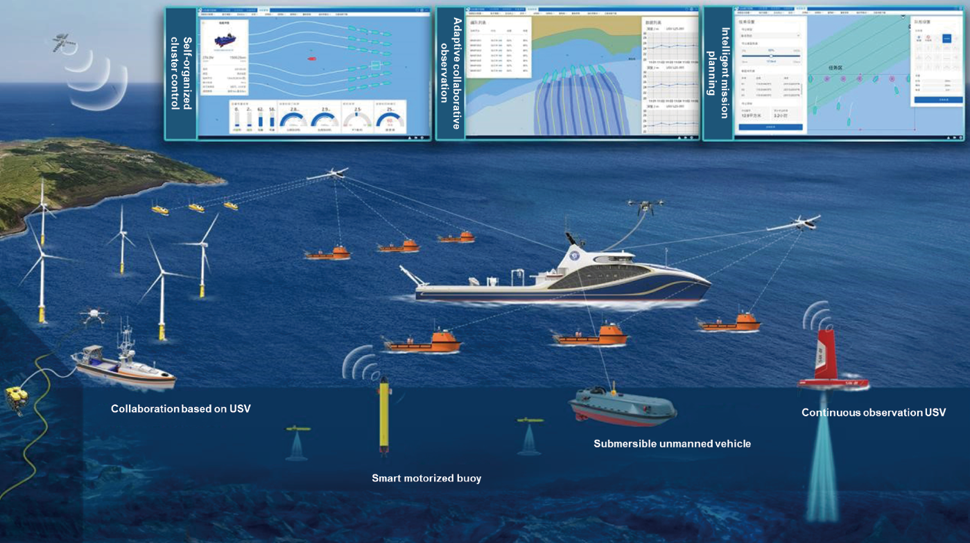
Based on the existing USV cluster control technology, it is proposed to use the smart mother ship as the carrier, and use various types of unmanned platforms in the air, sea, and submarine to form a cross-domain collaborative network to build a set of ” Intelligent Swift Ocean Observing System “(ISOOS). As a vehicle and control center for a variety of unmanned equipment, the smart mothership can carry a large number of unmanned boats, drones, autonomous underwater vehicles, and other equipment to quickly reach the target area according to mission requirements, it is able to deploy unmanned vehicles efficiently with the launch and recover system onboard.
02 Solution:
To build a cross-domain collaborative three-dimensional observation network from 4,000 meters in the air to 1,500meters underwater and cover 160 kilometers horizontally, providing a brand-new ocean observation way, so it has far-reaching scientific significance and broad application prospects.
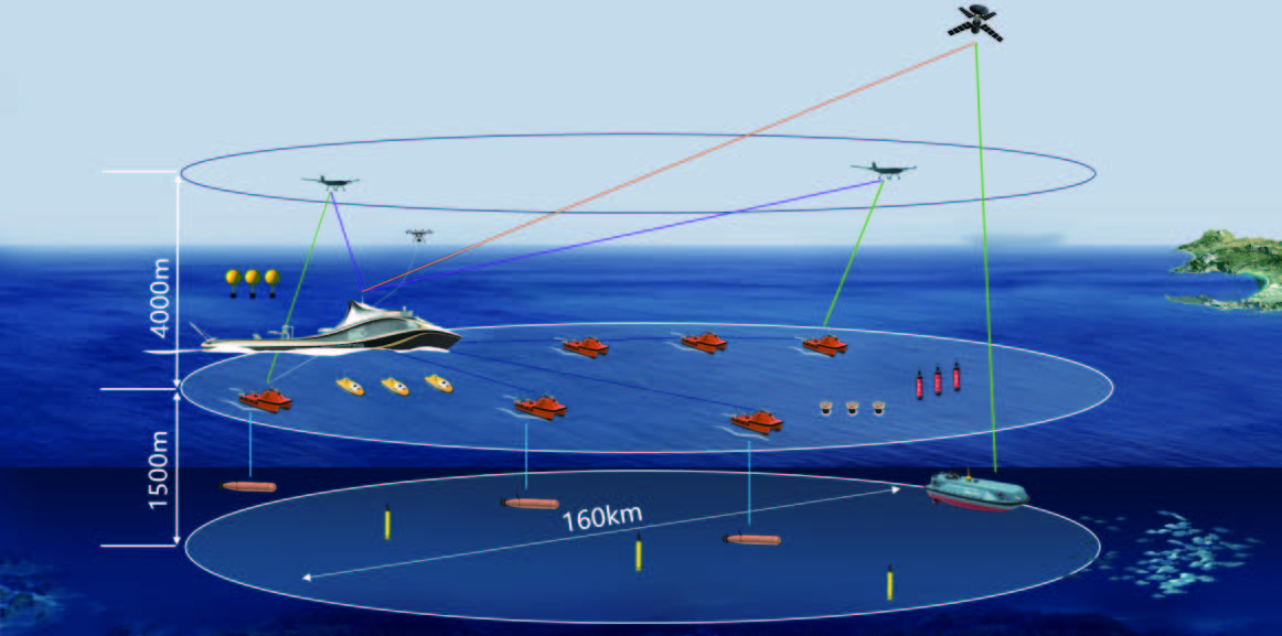
(Solution 1 )
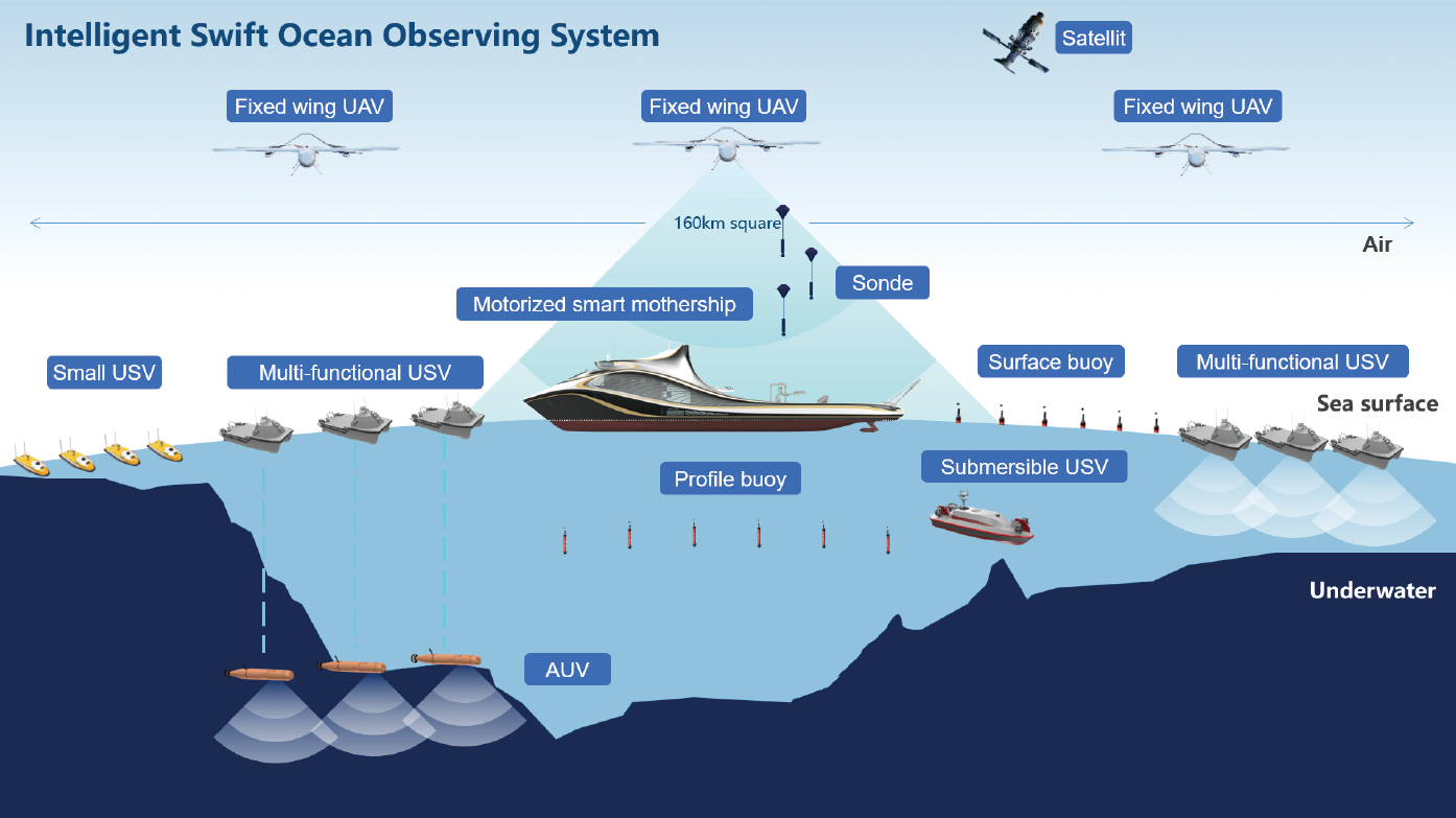
(Solution 2)
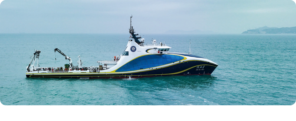
The “Zhuhai Yun” intelligent unmanned system mother ship with No, R1, M, and I intelligent symbols can carry large USV L25, medium USV M40P, small USV SE40, vertical take-off and landing drones, unmanned underwater vehicles, etc.
03 Capability:
3.1 Efficiency Improvement
Increase the efficiency of marine surveying and mapping by dozens to hundreds of times.
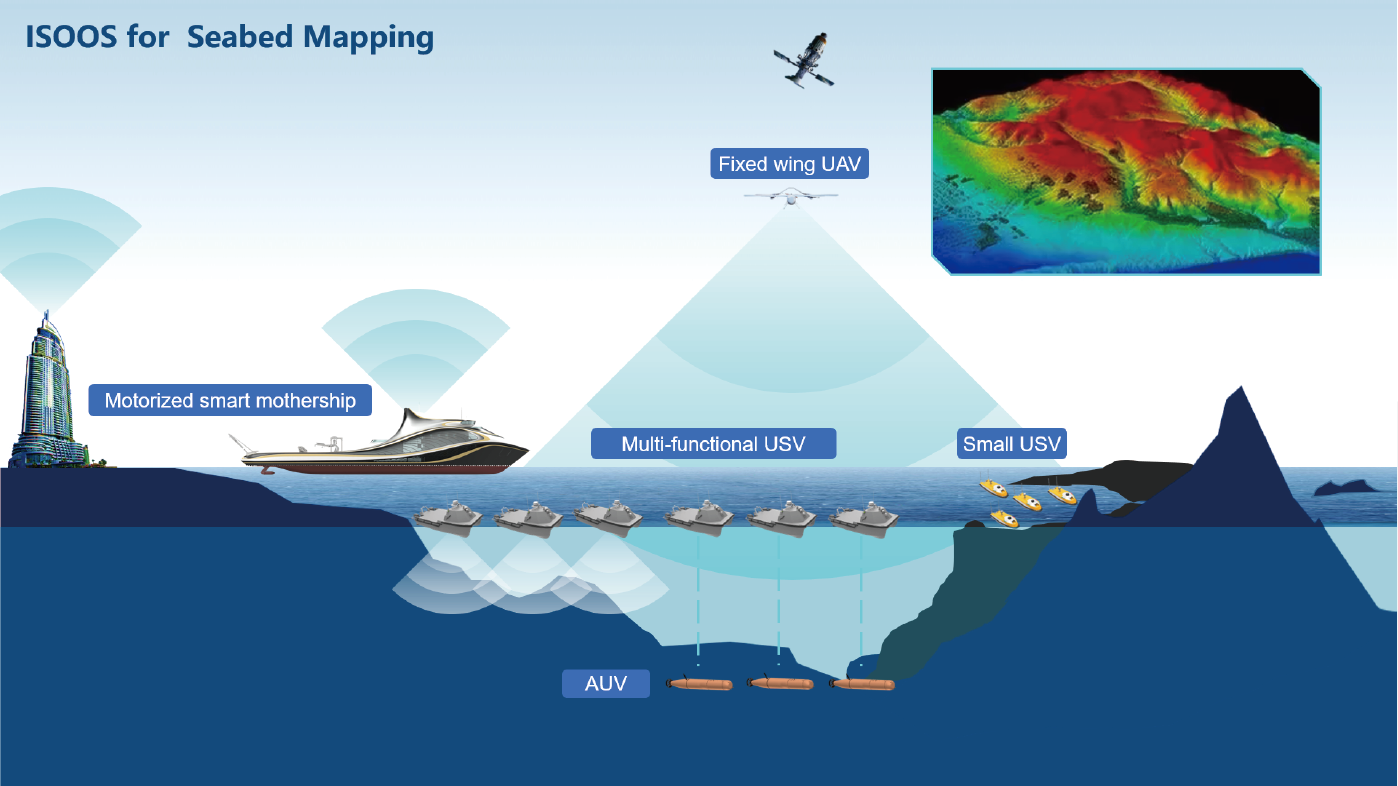
Schematic diagram of seabed surveying and mapping
Large USV on the water surface and autonomous underwater vehicles work together in deep water areas, Large USVs are used for multi-beam echo sounder surveys in shallow water areas, and small USVs are used for single-beam bathymetry survey in ultra-shallow areas. A variety of unmanned systems work together to improve the efficiency of marine surveying and mapping by dozens or even hundreds of times.
3.2 Efficiency improvement
Efficient survey in offshore oil and gas and offshore wind power pipeline, cable detection and engineering.
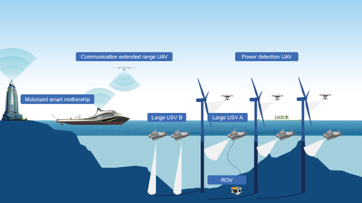
Schematic diagram of offshore wind farm operation and maintenance
Release a formation of at least 6 large USVs, 3 of which are equipped with multi-beam and side-scan sonar, and 3 are equipped with sub-bottom profilers to detect the buried/suspended situation of cables, and the synchronous operation of multiple boats improves the performance of large-scale offshore wind farms survey and maintenance efficiency.
3.3 Complete the mission impossible
Enhance scientific research and complete the observation of special physical ocean phenomena.
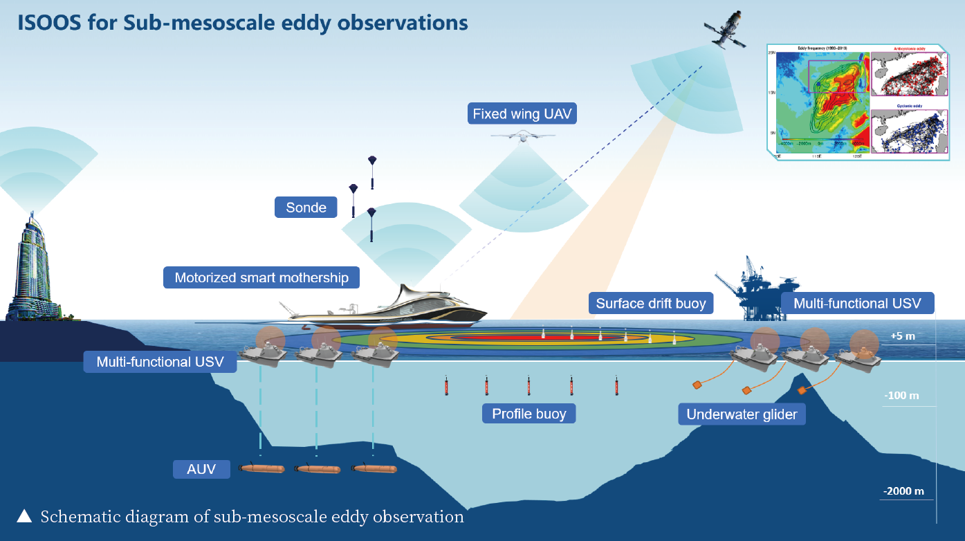
Using the network of large USV equipped with automatic towing winches, synchronously acquire high temporal-spatial resolution three-dimensional data of the upper ocean and the sea-air interface. Supplementary observations provided by autonomous underwater vehicles, profile buoys, surface drifting buoys, and drifting small floats.
3.4 Complete the mission impossible
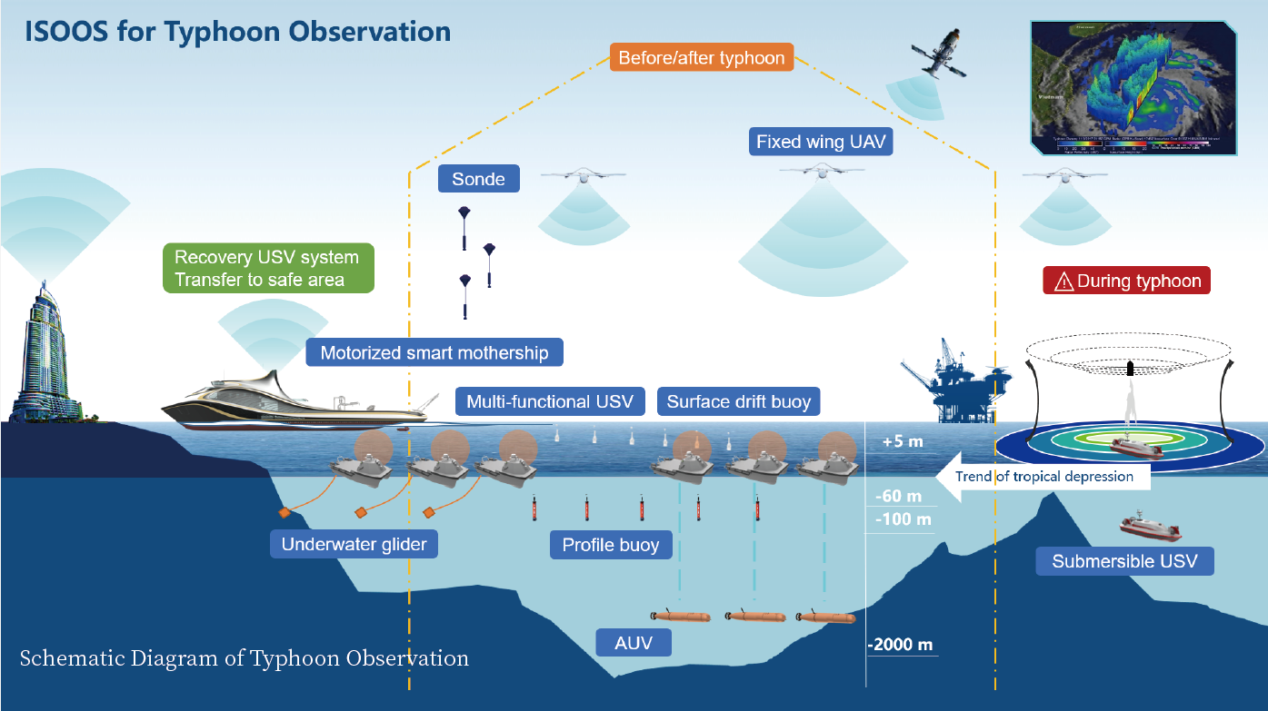
Serving disaster reduction and carrying out observations of severe weather such as typhoons.
3.5 Abundant application possibilities
Instead of the existing seismic survey method to carry out mineral resource survey, the scope of the seismic survey can be expanded, and the time efficiency of oil and gas exploration can be increased several times. A wide range of underwater object detection can be carried out in defense applications.
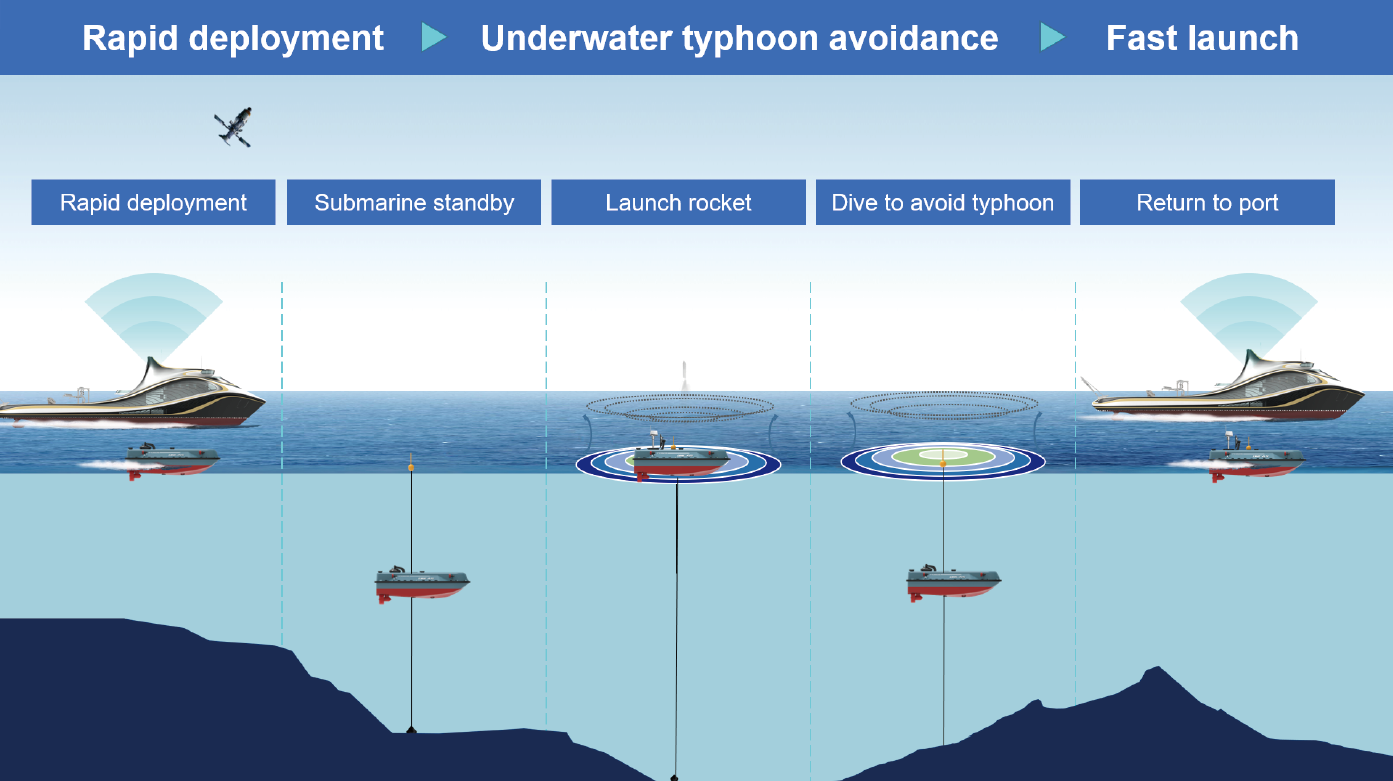
Implement multi-node cross-domain network stereoscopic observation before and after the typhoon, and deploy and recover the submersible unmanned vehicle. During the typhoon, the submersible unmanned vehicle mainly tracks and observes the typhoon and launches sounding rockets in the center of the typhoon. Disposable profiling buoys, surface drifting buoys, and small drifting buoys can collect data before, during, and after a typhoon. The operation mode of the submersible unmanned boat is shown in the figure below.
04 Features:
4.1 Agility
Based on the intelligent mother ship, achieve the rapid long-distance transition, deploy the recovery system in batches, ensure the rapid launch of the unmanned system. Use the air-sea submersible unmanned system equipment to carry out large-scale simultaneous observation.
4.2 Intelligence
Based on the task-oriented adaptive networking scheduling strategy, optimize the platform and system level, improve the collaborative control capabilities of wide-area, multi-node, air-sea, and submarine cross-media networking, and ensure the intelligence level of task scheduling. Improve the effectiveness of wide-area and cross-media networking communication systems in complex marine environments, and ensure the level of intelligence in network link optimization and resource allocation.
4.3 Adaptability
Guarantee the survival and operational capabilities of the system under extreme ocean conditions, and can cope with difficult tasks such as typhoon observation. Taking into account meteorological, power, biochemical, terrain, and other elements, large USVs with observation modes such as navigation, fixed-point, and towing can adapt to tasks in complex ocean environments, and cooperative networking to make up for the shortcomings of unmanned vehicle in high altitudes and deep seas.
05 Conclusion:
The ISOOS system is an advanced new technology system for marine surveys. It uses a smart mothership as a carrier and control center for various unmanned equipment and can carry a large number of unmanned boats, drones, and autonomous underwater vehicles according to mission requirements. Approach the target area quickly and release unmanned equipment in batches.
Efficiently complete oil and gas resource exploration, marine surveying and mapping, marine engineering survey, physical ocean observation, severe weather investigation, etc. It can improve the efficiency of marine survey work such as oil and gas resource exploration by several times or even dozens of times, and can also provide colleges and universities with tools for large-scale underwater object detection for defense security, and provide revolutionary support to national marine science, marine engineering, and maritime defense.
— END —
The Intelligent Swift Ocean Observing System: Advancements in Ocean Exploration
- in !!!, Artificial intelligence, Mobile, News
- on 12 October 2023

The development of the Intelligent Swift Ocean Observing System (ISOOS) is revolutionizing our understanding of the ocean. This system utilizes a network of unmanned aerial vehicles (UAVs), unmanned surface vessels (USVs), and autonomous underwater vehicles (AUVs) to map targeted regions of the ocean in three dimensions. By employing this advanced technology, researchers can gather more data in a safer, faster, and more efficient manner than ever before.
ISOOS operates by using a smart carrier as the mobile system base and control center, allowing for fast and simultaneous observations of any targeted region. The network of unmanned vessels and vehicles offers adaptability and flexibility in exploration and research endeavors. ISOOS is particularly valuable for investigating submesoscale eddies, circular currents of water that oppose the general ocean current. These eddies, which are less than 100 kilometers wide, are poorly understood due to their high variability in space and time. ISOOS enables researchers to rapidly scan areas where these eddies occur, providing valuable insights into their occurrences and their role in global ocean dynamics.
Additionally, ISOOS is highly efficient in mapping the ocean floor, a task that is traditionally time-consuming and costly. By leveraging the coordinated efforts of USVs and AUVs, ISOOS significantly increases mapping efficiency. For example, during the search for the suspected crash of flight MH370, AUVs and USVs successfully mapped 125,000 square kilometers of the ocean floor in just under five months, providing new insights into underwater terrain.
ISOOS has the potential to revolutionize various aspects of ocean exploration and scientific research. By eliminating the need for direct human involvement, missions can be operated remotely, saving time, resources, and effort. ISOOS can be utilized for searching for ship or aircraft wreckage and capturing time and space-sensitive oceanic phenomena that would otherwise remain unstudied using traditional methods.
The Intelligent Swift Ocean Observing System opens up new avenues for exploration and scientific advancement in our understanding of the ocean. Through the integration of unmanned vessels and vehicles, ISOOS offers unparalleled capabilities in data collection, mapping, and research.
– Source: Chao Dong et al, Intelligent Swift Ocean Observing System, Ocean-Land-Atmosphere Research (2023). DOI: 10.34133/olar.0022
Intelligent Swift Ocean Observing System
Chao Dong, Dake Chen, Dongxiao Wang, Wen Xu, Tao Lian, Shilu Dai, Yunfei Zhang, and Ce Zheng
Ocean-Land-Atmosphere Research
23 Oct 2023
Vol 2
Article ID: 0022
Field observations are essential for the advancement of marine science and engineering. Almost all breakthroughs in the history of oceanography were propelled by innovations in observing technology. For example, the invention of deep-sea submersibles led to the discovery of hydrothermal vents and associated dark biosphere [1,2], the launch of ocean observing satellites made it possible to view the state and variability of global surface ocean in a quasi-simultaneous fashion [3,4], and the construction of the global network of Argo profiling floats greatly improved monitoring, understanding, and prediction of the large-scale ocean circulation and climate change [5]. Nevertheless, existing ocean observing technologies are still far from fully meeting the needs of scientific research and engineering application, and new innovations are constantly in demand.
A new trend in ocean observing technology is the development of unmanned, intelligent vehicles and their coordinated operations, including Unmanned Aerial Vehicles (UAVs), Unmanned Surface Vehicles (USVs), Autonomous Underwater Vehicles (AUVs), and so on, because of their versatility, flexibility, adaptability, and efficiency. In recent years, each type of these vehicles has become better designed and constructed, playing an increasingly more important role in ocean observation and exploration. However, using them in a cross-platform, cross-domain, and intelligently coordinated manner is still a formidable task. One notable attempt toward this direction was made by Ocean Infinity in 2018, when it was commissioned by the Malaysian government to search the suspected crash area of Flight MH370 [6]. The company employed 6 AUVs with hydroacoustic equipment for near-bottom detection, paired with 6 USVs for one-to-one communication and high-precision positioning. While no fragments of a crash was found, a search of 125,000 km2 of seafloor was completed in 138 days, many times more efficient than traditional searching techniques.
Here, we introduce an Intelligent Swift Ocean Observing System (ISOOS) that our team is constructing under the auspices of the National Natural Science Foundation of China. The basic idea is, using a smart carrier as the mobile system base and control center, to build a cross-domain network of several tens of UAVs, USVs, and AUVs for fast, simultaneous, 3-dimensional observation of any targeted regions (Fig. 1). The main components of ISOOS under development include a software/hardware system for coordinated control, communication, positioning, and navigation; a console for data visualization and operation management; and a submersible USV and a double-mode AUV that can also operate as a glider [7]. In the meantime, we have many existing supporting platforms for ISOOS, including a highly intelligent carrier called Zhuhai Cloud (Fig. 2), which is already in service this year, as well as a suite of USVs and UAVs of different sizes and types, plus expendable instruments such as surface drifters, profiling floats, and sounding balloons and rockets.
The ISOOS is particularly useful for capturing oceanic phenomena of high spatiotemporal variability, and thus capable of fulfilling the tasks that are either impossible to approach or inefficient to complete with any existing technologies. For instance, submesoscale eddies play a key role in the global ocean dynamics, but their 3-dimensional structure is notoriously hard to catch due to their relatively small spatial and temporal scales. A system like ISOOS can take a fast, stereoscopic scan of these eddies in regions they tend to occur, and thus is likely to reveal the whole picture of them for the first time. As another example, only a small fraction of the seafloor is directly mapped at present because mapping is expensive and time-consuming. Using a coordinated network of USVs and AUVs, ISOOS can certainly help to increase the mapping efficiency in an unprecedented fashion. There is no doubt that, as an intelligent, efficient, and reliable ocean observing tool, the ISOOS will have great potential not only for scientific exploration, but also for a broad range of practical applications.

Acknowledgments
Funding: This work was supported by the National Natural Science Foundation of China (grant no. 42227901).
Author contributions: C.D. and D.C. wrote the manuscript, and all authors contributed to the discussions of the scientific content and to the improvement of the manuscript.
Competing interests: The authors declare that they have no competing interests.
References
1 Lonsdale P. Clustering of suspension-feeding macrobenthos near abyssal hydrothermal vents at oceanic spreading centers. Deep-Sea Res. 1977;24(9):857–863.
2 Corliss J, Dymond J, Gordon L, Edmond J, von Herzen R, Ballard R, Green K, Williams D, Bainbridge A, Crane K, et al. Submarine thermal springs on the Galapagos rift. Science. 1979;203(4385):1073–1083.
3 Bernstein RL. SEASAT 1. J Geophys Res. 1982;87:3173–3438.
4 Hofer R, Njoku EG, Waters JW. Microwave radiometric measurements of sea surface temperature from the Seasat satellite: First results. Science. 1981;212(4501):1385–1387.
5 Johnson GC, Hosoda S, Jayne SR, Oke PR, Riser SC, Roemmich D, Suga T, Thierry V, Wijffels SE, Xu J. Argo-two decades: Global oceanography Revolutionized. Ann Rev Mar Sci. 2022;3(14):379–403.
6 Bernard L. Underwater drones start ‘last’ search for MH370. The Times. 2018 Jan 05.
7 Xu W, Li JL, Li YP, Chen HF, Yang SQ, Zeng JB, Wang YH. Networks of unmanned underwater vehicles for ocean exploration: Advances and prospects. Science and Technology Foresight. 2022;1(2):60–78.
Published In Ocean-Land-Atmosphere Research
Hidden under the vast crystal blues of the Pacific, a submarine is hunted from above. A centuries-old game of cat and mouse drives the technological advancements in the ongoing race to conquer the undersea realms. Today, enhanced capability in both anti-submarine and anti-surface technology is transforming anti-submarine warfare, known as ASW.
Modern submarines are not only quieter than their ancestors, but they are also better equipped to deal with the threats that shadow them from above. For now, submarines are ahead in the race. But, with the emergence of unmanned autonomous technology there is the tantalizing possibility that in the future we will be able to detect, localize and track submarines across huge distances more effectively and at lower cost. As we enter into a new era of ASW operation, we take a look at the challenges in unmanned solutions remaining to be overcome before the tide is turned against those hidden under the waves.
The ASW industry is an endless conveyor belt of innovation, battling to develop the next game-changing technology. NATO navies already field impressive ASW capabilities, including modern frigates deploying low-frequency active sonar and advanced location devices on new modern submarines. Air assets such as specialized planes known as Maritime Patrol Aircraft, or MPAs, can deploy and monitor passive or active sonobuoys fields, and helicopters, MPH, can deploy sonobuoys and/or active dipping sonar.
While manned assets are a vital part of ASW operations, reductions in funding and new advances in submarine technology has led countries around the world to begin to develop unmanned systems for ASW. Although today’s unmanned technology has a lower-performance payload than manned, these systems offer an enormously cheaper alternative that, as a team, offer the potential to cover vast ranges while delivering covertness that may carry great tactical advantages.
“Anti-submarine warfare is a highly asset-intensive process that requires significant numbers of highly capable platforms deploying a variety of sensors. To operate these platforms and sensors at their potential, requires a cadre of trained and skilled human operators, as well as an appetite for risk, as the submarine is an increasingly dangerous adversary,” explains Dr. Kevin LePage, ASW program manager at the NATO Science and Technology Organization (STO) Centre for Maritime Research and Experimentation (CMRE) in La Spezia, Italy.
The STO-CMRE is the NATO innovation hub for developing underwater technologies for a range of maritime applications, including minesweeping and ASW operations. Their objective is to deliver innovative and field-tested Science and Technology (S&T) solutions to address the defense and security needs of the Alliance.
CMRE operates two research vessels that enable S&T solutions to be explored and developed at sea. The largest of these vessels, the NATO research vssel Alliance, is an ice-capable global class vessel that is one of the world’s quietest ship, allowing for precision acoustic studies to be conducted in environments operationally relevant to NATO. The operational experimentation being conducted from this platform has as its goal the development of cheaper, smarter solutions to give the nations a greater range of options in setting requirements for future ASW capability.
Two of the CMRE’s most valuable assets are their sophisticated autonomous underwater vehicles (AUVs), capable of operating with a degree of independent decision-making abilities. The CMRE is working to give the AUVs the capability to listen, to evaluate and to signal the presence of submarines to operators in the command and control center.
Like the increasingly used unmanned vehicles for air and land, AUVs can operate more and more flexibly in the littoral and open oceans. And, as further systems are introduced into the mix, the way potential enemies have been used to working underwater will begin to be challenged.
LePage said, “ASW has for years relied on certain remote-controlled, monitored or unmanned sensor platforms, such as the sonobuoys deployed by Maritime Patrol Aircraft and Helicopters, and permanent or deployable sensing arrays. More recently, we have seen the increased use of unmanned autonomous vehicles (UAVs) for intelligence, surveillance and reconnaissance (ISR) missions, mostly for visual confirmation. However, the fully-fledged use of unmanned systems either as an organic or standalone capability for ASW is just beginning to emerge. One example is the ACTUV, a 40-meter long-endurance unmanned ASW platform being developed by DARPA and ONR in the U.S.”
The ASW Continuous Trail Unmanned Vessel (ACTUV) is an unmanned vessel designed by the Defense Advanced Research Projects Agency (DARPA). The state-of-the-art vessel is built specifically to track quiet diesel-electric submarines, at a fraction of their size and cost.
The project also seeks to advance unmanned system autonomy so that maritime operators are able to deploy platforms capable of crossing thousands of kilometers and undergoing missions for months at a time with minor supervision.
Another example of advancements in unmanned technology for maritime security is the Seagull unmanned surface vessel (USV) developed by Israel’s Elbit Systems. At 12 meters long, the USV is claimed to be a first-of-its-kind maritime robot designed for missions in underwater mine hunting, mine clearing, anti-diver and ASW operations. The Seagull USV uses electro-optic and infrared sensors along with various sonars to search for underwater threats.
NATO at the Core of ASW Innovation
“At CMRE we have been working under NATO Allied Command Transformation, or ACT, to develop Autonomous Security Networks for ASW. This effort is divided into three projects: (1) Maritime Unmanned Systems for ASW where we engage in spiral S&T development of an autonomous ASW network based on unmanned underwater vehicles. We deploy these yearly into National and NATO ASW exercises; (2) the UWNet project, where we develop technology for military digital underwater communications networks, which is actually a critical enabling capability across all the maritime warfare domains; and (3) the Decision Support project. This final project is where we engage in ASW operations research and analysis to develop candidate tactics and decision support tools for both human operators and robots,” explains LePage.
After years of research and development in unmanned ASW networks, CRME has come across several technological hurdles that still need to be surmounted, such as the development sufficiently effective autonomous sensing, processing, classification and tracking algorithms to arrive at the required probability of detection and false alarm.
Parallel studies are being conducted to refine algorithms for advanced collaborative robotics to allow autonomous vehicles to provide adequate area coverage, barrier performance and ability to trail a target. Work is also ongoing to develop higher throughput secure underwater communications links to enable collaboration of unmanned underwater assets and provide connectivity to command and control (C2). A final piece has been the development of effective on board environmental awareness and robotic decision support.
João Alves, Underwater Communications project lead at CMRE, said, “We have made significant strides in all these areas, but there is much work that needs to be done. One recent development we are especially proud of is the promulgation of the JANUS digital underwater telephony standard, STANAG 4748. It has been developed by CMRE with the collaboration of stakeholders across NATO, the nations and industry. This is an achievement with a great impact on NATO, non-NATO, civilian and military subsea communities. We have, for the first time, the conditions to break the interoperability barrier that still stands in underwater digital communications. STANAG 4748 is the absolute first internationally promulgated standard on digital underwater communications.”
Since 2011, the CMRE have been testing their robotic network at sea against submarine targets. While they were not able to go into the details of their findings, it was clear that these types of unmanned ASW networks hold promise to deliver the next increment in ASW capability of the nations.
Challenges of Unmanned Systems in ASW Ops
For years unmanned systems have been used for ASW operations in various forms. But, there are four fundamental challenges to overcome before these systems are able to reach their full potential in maritime security. The first is to develop the concept of operations, or CONOPs, where decisions need to be made in how to deploy unmanned platforms, in what mix and for what missions.
The second challenge is to determine how these systems will be integrated together with existing platforms under a common command, control and communications (C3) architecture so that they can add value to an ASW task group. To do this, the CMRE believe the industry will have to make unmanned systems interoperable – to define standard communications protocols and message sets so that they can collaborate and share information, with the objective to provide cues to operators that can be trusted, finding subs when they are present while not flooding the system with false alarms.
The third challenge is the S&T challenge. Mainly, discovering how to make unmanned systems intelligent and able to learn from their surroundings, how to form teams and undertake ASW missions. First, there need to be improvements in the technology’s sensors and communications links – especially underwater. Also, unmanned platforms must be imbued with the ability to learn, plan, collaborate and act to maximize effectiveness, working initially under the supervision of manned assets, but with the goal of reducing as much as possible the workload to the operators. Since unmanned systems will not in general have the luxury of constant and reliable communication with operators, the CMRE is striving to develop the science and technology required to one day allow these vehicles to become truly autonomous.
The fourth and final challenge is to develop the engineering solutions that will allow maximum freedom of use of unmanned systems. This challenge includes developing energy solutions for maximum speed and endurance; heavy weather launch and recovery for maximum flexibility in operations; communications and energy infrastructure technology; underwater navigation to increase the precision of detection and cueing; and maneuverability, stability (for sensors) and seakeeping.
The Unmanned Game of Cat and Mouse
“A cornerstone of ACT and CMRE’s approach has been to engage in operational experimentation and demonstration with a continually improving unmanned ASW demonstrations. By engaging with the operational community in ASW exercises, we can capture requirements for a future unmanned ASW capability and incorporate updates for testing in the next seagoing cycle,” explains Christopher Strode, the ASW Decision Support project lead at CMRE.
“Some significant potential for new capability in operations analysis based on our ASW planning and analysis tools certainly exists, and the ASW commander in NATO task groups could certainly gain by having a tool which would allow him to optimally deploy the ASW assets at his disposal – whether legacy systems or autonomous systems. For digital underwater communications, we see significant interest in providing situational awareness to submarines, whether the surface white picture, METOC or other information for ASW. Also, CMRE’s digital underwater communications technologies have captured the submarine rescue exercise community.”
The CMRE will deploy their unmanned ASW network into the Dynamic Mongoose 2017 – the second annual NATO-led maritime ASW interoperability exercise, scheduled June 26 to July 8, 2017. This network will include powered UUVs towing arrays and surface and underwater gliders. The systems will provide a communications backbone and oceanographic characterization to assist the UUVs in working together and with C2 to make optimal decisions.
Dr. Alessandra Tesei, project leader for operational experimentation at CMRE explains, “In the past, we deployed this same network into the Proud Manta 2012 and 2013, as well as Dynamic Mongoose 2015, so we are starting to generate a track record in this regard. But our vision for the future is that unmanned technologies will significantly aid the Alliances ASW mission by putting scalable, flexible, cost-effective, long-endurance high-performance unmanned ASW sensing networks at the fingertips of ASW commanders, leading to much-increased flexibility and effectiveness in ASW operations.”
The future will entail a shift in the approach to ASW operations. Maritime security is moving from a small number of expensive platforms to an unmanned alternative, capable of unleashing vast numbers of platforms over great distances at low-cost. This innovative technology hails the start of a new kind of game of cat and mouse. As these systems grow and advance at an exceptional rate, submarines grow nervous under the rolling waves that once promised refuge.
Acknowledgements
João Alves (UWNet PL), Chris Strode (Decision Support PL), Dr. Alessandra Tesei (MUS for ASW PL), Dr. Kevin D. LePage, Principal Scientist and Cooperative ASW Program Manager (NATO, CMRE).
---------------------------------------------------------------------------------------------------------------------
FUTURE WAR PAPER Unmanned Underwater Vehicles: Resurrecting Forcible Entry From the Sea
Major Mathew K. Lesnowicz, USMC


No comments:
Post a Comment