 |
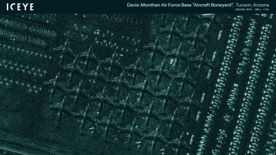
| ICEYE Dwell Fine image of the Davis-Monthan Air Force "Boneyard" in Tucson, Arizona, US taken on March 1st, 2024. |
ICEYE expands high-resolution SAR data products with Dwell Fine imaging mode
Dwell Fine deepens understanding of on-the-ground situations and enables detailed exploration of human-made structures against natural backgrounds.
Helsinki, March 12, 2024 — ICEYE, the global leader in SAR satellite operations for Earth Observation and persistent monitoring, today introduces its Dwell Fine imaging mode, which adds to the unique capabilities of Dwell mode and builds on the release of Spot Fine, launched in June 2023. With a 50-centimeter resolution, Dwell Fine enables a deeper understanding of changes on the Earth's surface, identification of specific models of aircraft on the ground and ships at sea, and exploration of human-made structures, such as vehicles and buildings, against natural backgrounds, such as tree canopy and vegetation.
ICEYE’s Dwell Fine is unique in commercial SAR satellite imagery. As a satellite orbits the Earth in Dwell Fine mode its radar signals focus on a defined area of the planet’s surface to create an image for 25 seconds – in contrast to the usual 10 seconds for a standard Spot image. Thanks to the longer duration imaging mode, Dwell Fine users can determine the shape of an aircraft's fuselage, wings, stabilizers, and engines; recognize narrow objects like power lines and antennas; or evaluate the extent and nature of damage to civil infrastructure. Short videos, composed of multiple images taken during collection and delivered as part of the Dwell Fine services, can detect vessels' movement, direction, and speed.
With its many practical applications, Dwell Fine can detect and emphasize the differences between human-made and natural features. And because images in Dwell mode are taken from a much more comprehensive range of angles, it can perceive objects through gaps in the trees and foliage.
Owner and operator of the world’s largest constellation of SAR satellites, ICEYE first introduced its Dwell mode in May 2023. With the introduction of Dwell Fine less than a year later, ICEYE underlines its commitment to constant innovation in serving private and public sector organizations globally with the most advanced commercial Earth Observation capabilities and SAR satellite imagery.
John Cartwright, ICEYE’s SVP and Head of Data Product, said: “Dwell is a first-in-the-world capability that just evolved into an even better one with the introduction of Dwell Fine. Sharpening the resolution down from one meter to 50 centimeters produces SAR satellite images with incredible clarity. This – combined with the ability of ICEYE satellites to observe any location on Earth every few hours, day or night, and in any weather – enables a level of change detection that's never been possible before.”
ICEYE’s radar antennae are one-of-a-kind in the SAR satellite sector, controlled by software to direct the radar beams to areas of interest as needed. This technology confers unique capabilities in the sector and provides greater versatility in imaging modes – ranging from the fine granularity of Dwell Fine to views covering tens of thousands of square kilometers.
ICEYE Dwell Fine mode images deliver a combination of 0.5 m resolution
and long radar illumination times for enhanced clarity. You can
distinguish details such as aircraft and vessel types, as well as
powerlines and launch towers. Dwell Fine mode includes Color
Sub-Aperture Images (CSI) and SAR video.
Teaming with Sandia General Atomics UAV's and Lynx SAR
The Lynx SAR/GMTI radar was developed for General Atomics by Sandia Labs. Lynx is a high resolution, synthetic aperture radar (SAR) that was designed and built by Sandia National Laboratories in collaboration with General Atomics (GA) for use in the Predator and later Reaper UAVs. The Lynx production weight is less than 120 lb. and has a slant range of 30 km moderate rain (4 mm/hr). There are weather effects since it operates in Ku band, centered on 16.7 GHz, but this gives it lots of bandwidth to achieve extremely fine range resolution.
It has operator selectable resolution and is capable of 0.1 m resolution in spotlight mode and 0.3 m resolution in stripmap mode. In ground moving target indicator mode, the minimum detectable velocity is 6 knots with a minimum target cross-section of 10 dBsm. In coherent change detection mode, Lynx makes registered, complex image comparisons either of 01 m resolution (minimum) spotlight images or of 0.3 m resolution (minimum) strip images.
In Spotlight Mode, the operator specifies the coordinates of a point on the ground and the SAR dwells on that point until commanded otherwise, or until the imaging geometry is exceeded. As with Stripmap modes, imaging may be on either side of the aircraft. This mode allows finer resolutions than the Stripmap modes. Resolution in range and cross range is achieved from 10 cm up to 3 m over a patch of 640x480 pixels. In addition, an auto-zooming feature is also supported, whereby subsequent images are formed at ever finer resolutions. This mode continues until the SAR’s limits are reached, or the system is commanded to do otherwise.
Thus combining Iceye Satellite SAR and GA-ASI UAV SAR gives tactical advantages. The Satellite gives rapid routine wide area coverage, zooming down to pretty good resolution. Disadvantage is that it is periodic and predictable, so a hostile force could predict its passing. The UAV doesn't cover as much territory, but it can provide on demand long endurance coverage, and can zoom into fine detail, and fuse other optical and IR sensors to resolve target details. Furthermore, an armed REAPER could provide rapid reaction attack.


No comments:
Post a Comment