The New Capella Space Satellite Generation: Acadia
Capella Space, an information services company providing Earth observation data on demand, unveiled on 21 January 2020 its evolved satellite design to enable on-demand observations of anywhere on Earth. Informed by extensive customer feedback and findings from the launch of Denali, Capella’s testbed satellite, the re-engineered design features a suite of technological innovations to deliver timely, flexible and frequent sub-0.5 meter very high quality images to the market. The enhanced technology package will deliver the most advanced offering for small satellite SAR imagery on the market.
“Our customers have spoken: today’s industry standard of waiting eight hours to receive data is woefully outdated. They want access to imagery that is reliable, timely and, most importantly, high-quality,” said Christian Lenz, vice president of engineering at Capella Space. “The innovations packed into our small satellite make Capella the first and only SAR provider to provide real-time tasking and capture of sub-0.5m very high-quality imagery anywhere on Earth at any time. This is a game-changer for a variety of industries—from monitoring military threats to assessing crop yields in agriculture to coordinating disaster response.”
The satellite evolution is a direct result of customer feedback, extensive on-orbit testing with Capella’s first testbed satellite Denali, as well as ground-based testing. Enhancements include:
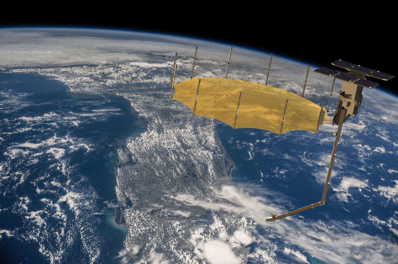
- Advanced design delivering high contrast, low-noise, sub-0.5 meter imagery: A 3.5 meter deployed mesh-based reflector antenna combined with a high power RADAR enable key performance improvements including quality advances.
- Extended duty cycle: A deployed 400 W solar array increases on-orbit duty cycle to 10 minutes per orbit.
- Continuous imaging over long distance: Advanced thermal management systems allow continuous imaging of up to 4000 km long strip images.
- Highly agile platform: Enabled by large reaction wheels, the new satellite quickly adjusts pointing to collect images from diverse targets.
- Staring spotlight image mode: New mode further enhances image quality with the ability to collect the highest commercially available multi-look data.
- Enhanced data downlink rate: A high average data rate downlink of 1.2 Gbps supports the massive image collection rate and extended duty cycle, providing more data per orbit than any other commercial SAR system in its class.
- Real-time tasking: A highly secure encrypted two-way link with Inmarsat through an exclusive partnership with Addvalue provides real time tasking capability for the entire Capella constellation.
The new satellite design cemented major deals with multiple divisions of the U.S. government, including a contract with the U.S. Air Force and National Reconnaissance Office (NRO). The technological enhancements will be embedded in Capella’s next six commercial satellites, named the “Whitney” constellation, starting with the launch of Sequoia slated for March of 2020. The Sequoia satellite is currently completing system level tests and will arrive at the launch site in early March.
Capella is also licensed by the National Oceanic and Atmospheric Administration (NOAA) for its 36 small satellite constellation, along with approval to sell the highest resolution legally allowed SAR commercial imagery to customers globally.
Capella Space is an information services company that provides on-demand sub-0.5m very high resolution (VHR) Synthetic Aperture Radar (SAR) Earth observation imagery. Through a constellation of small satellites, Capella is providing easy access to frequent, timely and flexible information affecting dozens of industries worldwide. Capella’s high-resolution SAR satellites are matched with unparalleled infrastructure to deliver reliable global insights that sharpen our understanding of the changing world – improving decisions about commerce, conservation and security on Earth.
Mar 14, 2024
EO
Land
Multi-purpose imagery (land)
Land surface imagery
Capella Space is a space technology company with data and satellite solutions for government and commercial use. Capella’s SAR satellites provide access to information to a number of industries worldwide, including defense and intelligence, supply chain, insurance, maritime and others.
Quick facts
Overview
| Mission type | EO |
| Agency | Capella Space |
| Mission status | Operational (nominal) |
| Launch date | 03 Dec 2018 |
| Measurement domain | Land |
| Measurement category | Multi-purpose imagery (land) |
| Measurement detailed | Land surface imagery |
| Instruments | Capella X-SAR |
| Instrument type | Imaging microwave radars |
| CEOS EO Handbook | See Capella Space X-Band Synthetic Aperture Radar summary |
Summary
About Capella Space
Capella Space is a space technology company with data and satellite solutions for government and commercial use, delivering commercial SAR imagery. Capella provides access to information affecting industries worldwide, including defense and intelligence, supply chain, insurance, maritime and others. Its SAR satellites deliver global insights into commerce, conservation, and security on Earth. Capella is headquartered in San Francisco, California with additional locations in Denver, Colorado and Washington, D.C.
Objectives and Applications
Capella Space is a space tech company with data and satellite solutions for government and commercial use. Capella delivers the best quality, highest resolution SAR imagery commercially available. Capella provides easy access to frequent and timely information affecting dozens of industries worldwide, including defense and intelligence, supply chain, insurance, maritime and others. Its market-leading SAR satellites are matched with unparalleled data infrastructure to quickly deliver reliable global insights that sharpen our understanding of the changing world.
Mission Capabilities
Each Capella Space satellite features an X-band Synthetic Aperture Radar (SAR) instrument, which operates with a bandwidth from 500 MHz up to 700MHz. This single-polarized instrument allows for imaging in various modes including spotlight, stripmap, and sliding spotlight. In certain modes the user can select the image size and is able to trade resolution for image quality, which enables a variety of uses including monitoring military threats, observing glacial meltwater dynamics, coordinating disaster response, detecting vessels at sea and persistent global change monitoring.
Performance Specifications
Spotlight mode provides high resolution imaging at 0.25 meter azimuth resolution for a swath of 5 x 5 km. The sliding-spotlight mode produces an image at 0.5 meter azimuth resolution at a scene length up to 10 km. Stripmap mode produces imagery at 1.2 meter azimuth resolution up to 100 km x 10 km.
Capella’s satellites operate in a variety of orbits at 45-degree mid-inclination (525 km altitude), 53-degree mid-inclination (575 km altitude), and 97-degree sun-synchronous orbit (525 km altitude). They have a period of 90 minutes which provides a revisit time of 2-5 hours with eight satellites.
Space and Hardware Components
The Capella's second-generation Whitney-class satellites have a mass of 110 kg and third-generation Acadia-class satellites have a mass less than 197 kg. With each launch of new satellites, Capella makes improvements to the instruments and radar system performance, such as the inclusion of polarimetric measurements in the next development. Once deployed, the small satellites unfold an antenna spanning approximately 8 square meters.
Capella Platform
Capella’s automated platform provides customers with direct access to task Capella satellites and collect imagery, making the Capella user experience as simple and straightforward as possible. Users can login to Console, define their area of interest, and search the existing catalog or submit a new acquisition tasking request. Once a new acquisition is collected, automatically processed, and delivered, customers receive an alert so they can login and access the SAR imagery in a timely manner.
Capella X-SAR (Synthetic Aperture Radar) Constellation
Sensor Complement Capella Spacecraft Capella Launches Mission Status ReferencesCapella Space is a U.S. satellite manufacturer and Earth observation company and the first American company to bring commercial SAR data to the broader market. Founded in 2016, Capella Space’s Synthetic Aperture Radar (SAR) satellites enable the company to deliver the highest quality, high resolution SAR • imagery commercially available with the fastest order-to-delivery time, empowering organizations across the public and private sector to make informed, accurate decisions.
The
Capella constellation will grow to 9 small satellites by the end of
2023. The first satellite of the Capella constellation launched in 2018.
As of 2024 10 more satellites have been launched, with at least five
more planned. 40) The radars are single polarization X-band systems,
capable of operating at 500 - 700 MHz bandwidth in stripmap, spotlight,
and sliding spotlight imaging modes.
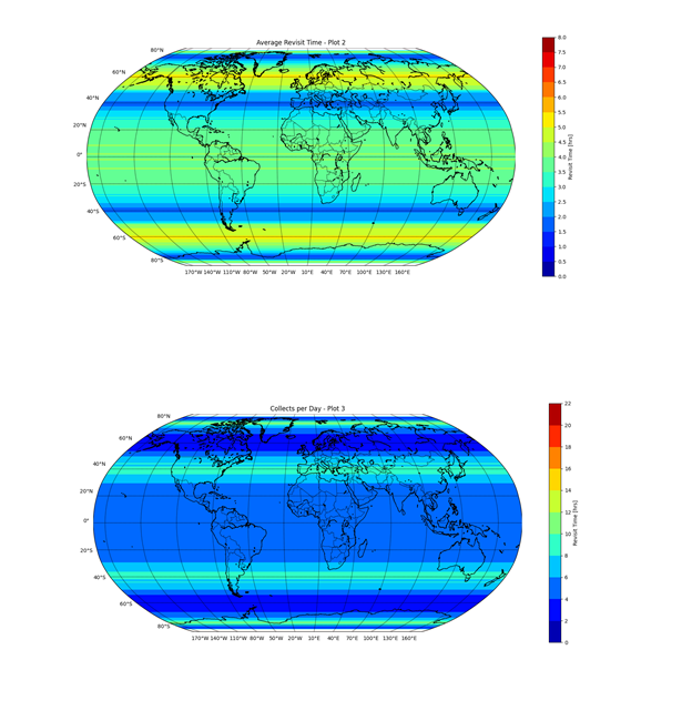
Figure 1: Charts illustrating global revisit rates and collects per day from the full constellation (image credit: Capella Space)
Each Capella satellite has a three-year design life. By launching 12 satellites per year, the constellation will maintain its imaging capability indefinitely. With the ability to continually update and refresh the satellite technology, Capella will be able implement improvements to the constellation and radar performance quarterly.
Parameter | 2018 | 2020 | 2021 | 2022 | 2023 |
Number of satellites launched | 1 | 1 | 4 | 2 | 5+ |
Use | Internal demonstration | Operational | Operational | Operational | Operational |
Total number of satellites | 1 | 1 | 5 | 7 | 5+ |
Number of orbital planes | xx | 1 | 3 | 3 | 3 |
Maximum revisit | weekly | 3-6 hours | 2-4 hours | 1-3 hours | 1-2 hours |
Sensor Complement (SAR)
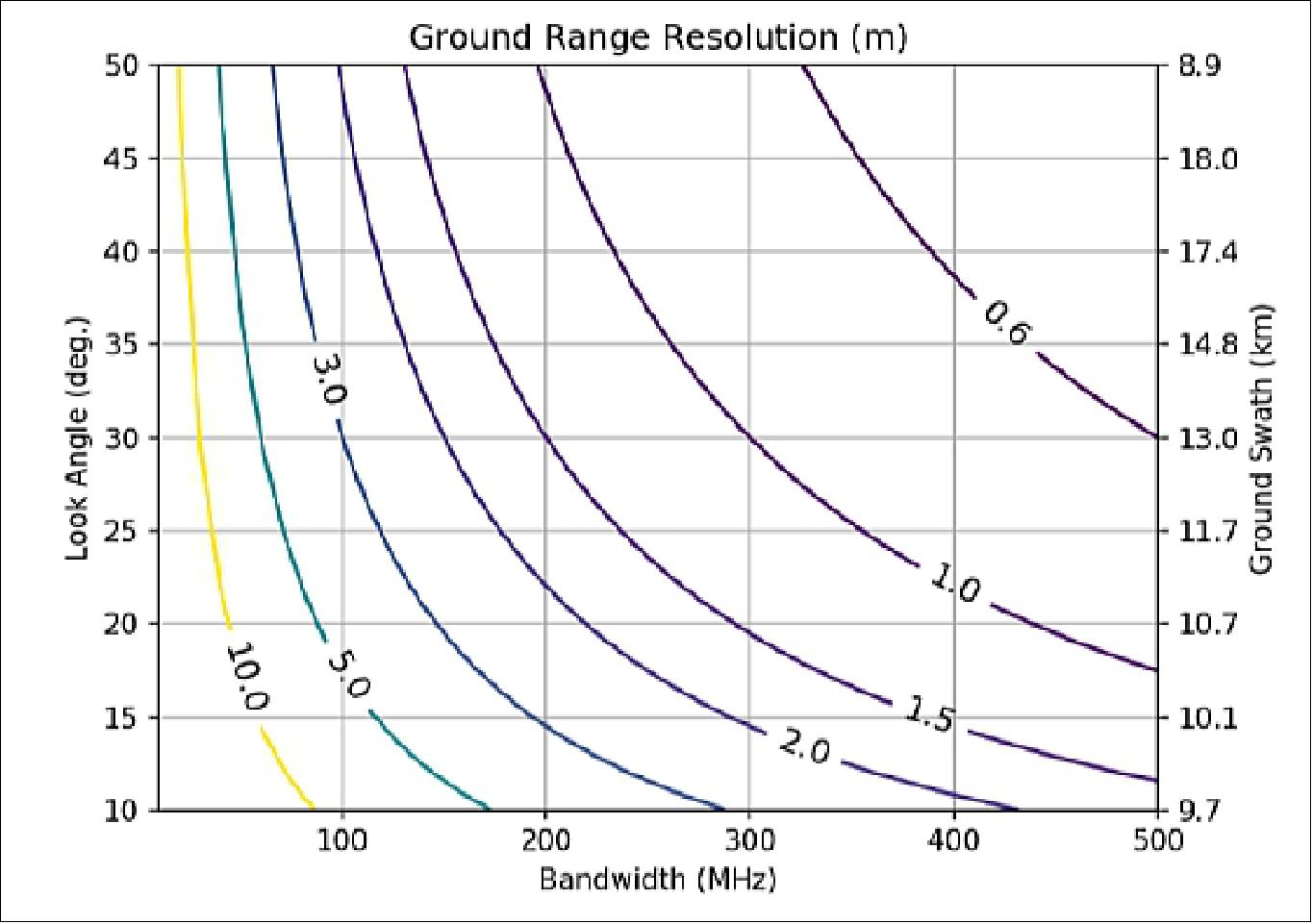
Capella SAR satellites operate at X-band with a bandwidth of up to 700 MHz. Ground resolution and swath width vary with look angle (Figure 2), but users will be able to select a combination of transmit bandwidth and PRF to meet their imaging requirements. The first Capella radars will operate with a single polarization. Improvement in radar system performance, such as polarimetric measurements, are planned for future generations of Capella satellites.
The system specifications for Capella’s satellites are listed in Table 2.
Frequency band | X-band (9.4 – 9.9 GHz) |
Polarization | Single-polarization (HH or VV) |
Orbit, orbital period, inclination | Polar & MIO, ~90 minutes, 97º, 53º & 45º |
Altitude at the equator | 485 – 525 km |
Imaging modes | Stripmap, spotlight, sliding spotlight |
Radar Imaging Modes
The Capella satellites will be capable of imaging in several modes, including spotlight, sliding spotlight, and traditional stripmap. These modes are described below. Note that for most modes, the user can select the image size, and is able to trade resolution for imaging quality.
Spotlight:
Capella satellites are capable of spotlight imaging, in which the beam
is focused on a single point on the Earth throughout the acquisition. In
this mode, azimuth resolution is limited by the duration of antenna
beam on the target. US regulations control the resolution at which
Capella can sell imagery. These multi-looked images are acquired using a
dwell time that results in a finer azimuth resolution than 0.25 m. The
raw SAR data is processed to full resolution, and then pixels in the
amplitude-only image are averaged (multi-looked) to produce
high-resolution, speckle-free imagery that Capella is legally permitted
to sell.
Multi-looking reduces speckle and increases detectability of
objects in a SAR image. However, with many SAR systems, multi-looking
comes at the cost of coarser azimuth resolution. Because Capella
spacecraft can stare at a point on the ground for tens of seconds,
Capella can provide multi-looked images constructed from tens of looks
at very high final resolution, e.g., 0.3 m.
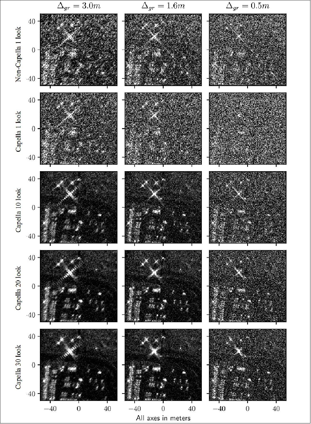
An example of the improvement in image quality achieved through multi-looked staring-spotlight has been simulated using airborne circular data. Simulated Capella multi-looked staring spotlight images are shown in Figure 3 (rows 2 through 5). Simulated single-look staring-spotlight acquisition images are shown in Figure 3 (row 1). The scene contains a road, cars in a parking lot, and several corner reflectors. NESZ values of typical large SAR systems such as TerraSAR-X are chosen to simulate the non-Capella radar simulated images. The simulations highlight contrast recovered in a SAR image by multi-looked staring-spotlight data processing, even when the NESZ is relatively poor (right-most column, rows 3, 4, and 5 in Figure 3. For example, the road emerges clearly in the 10-, 20-, and 30-look Capella images, but is hard to distinguish in the non-Capella radar single-look image despite that system having a lower NESZ. Note that in each column, multi-looking does not degrade resolution.
Capella satellites will also be able to acquire multiple staring spotlight images adjacent to each other. Each acquisition will have a shorter dwell time than the maximum dwell time possible with a single-spot staring spotlight acquisition, so either the resolution of each spot will be degraded as the number of spots increases, or the number of looks available for multi-looking will decrease as the number of spots increases. This mode is useful for extending the width (swath) of an area being imaged. For imaging a larger area in the along-track direction, i.e., increasing the length of a spotlight acquisition, sliding spotlight (see below) is more efficient. Maximum image sizes for 0.3 m and 1 m azimuth resolutions and associated number of looks for staring spotlight and multi-spot spotlight are shown in Table 3.
Maximum Image Size (km x km) | Azimuth Resolution (m) | Number of Looks |
5 x 20, 10 x 10 | 0.3 | 10 |
5 x 20, 10 x 10 | 0.3 | 20 |
5 x 10 | 0.3 | 30 |
5 x 30, 15 x 10 | 1.0 | 10 |
5 x 20, 10 x 10 | 1.0 | 20 |
5 x 20, 10 x 10 | 1.0 | 30 |
Sliding Spotlight: This
mode is a standard Synthetic Aperture Radar imaging mode. The swath is
limited by a combination of the look angle, the radar beamwidth, and the
Pulse Repetition Frequency (PRF) selected for the acquisition. The PRF
is selected to either provide maximum swath with reduced azimuth
ambiguity sidelobe ratio performance, or reduced swath with better
azimuth ambiguity sidelobe ratio performance. The minimum slant range
resolution is 0.3 m.
Capella satellites capture a wide-swath SAR
image in a single horizon-to-horizon pass by collecting multiple
sequential stripmap swaths adjacent in the range direction. The number
of sequential stripmap swaths is limited by the length of the final
wide-swath image and spacecraft slewing times. Stripmap image sizes are
listed in Table 5.
Image Length (km) | Best Theoretical Azimuth Resolution (m) |
10 | 0.018 |
20 | 0.034 |
30 | 0.049 |
40 | 0.065 |
50 | 0.080 |
60 | 0.095 |
70 | 0.109 |
80 | 0.124 |
90 | 0.137 |
100 | 0.151 |
125 | 0.184 |
150 | 0.215 |
175 | 0.243 |
200 | 0.274 |
Stripmap and Multi-swath Stripmap: This mode is a standard synthetic aperture radar stripmap imaging mode. The swath is limited by a combination of the look angle, the radar beamwidth, and the PRF (Pulse Repetition Frequency) selected for the acquisition. The PRF is selected to either provide maximum swath with reduced azimuth ambiguity sidelobe ratio performance, or reduced swath with better azimuth ambiguity sidelobe ratio performance. The minimum slant range resolution is 0.3 m.
Capella satellites will capture a single wide-swath SAR image in a single horizon-to-horizon pass by collecting multiple sequential stripmap swaths adjacent in the range direction. The number of sequential stripmap swaths is limited by the length of the final wide-swath image and spacecraft slewing times. Stripmap and multi-swath stripmap image sizes are listed in Table 5.
Image Length (km) | Image Width (km) |
10-30 | 50 |
40 | 40 |
50-140 | 30 |
150-780 | 20 |
790-2100 | 10 |
With six satellites in two planes, repeat-pass (repeat-track) interferometric measurements are possible according to timeseries 0 in Table 6 (i.e., collections at hours 0, 54, 120, 174, ...). In addition, a different timeseries of repeat-pass interferometric collections made at a different look angle, but of the same area on the ground, is possible 12 hours later, i.e., at timeseries 1 in Table 6 (hours 12, 66, 132, 186, ...). Notice that the timeseries sequence repeats after 10 time-series, or 120 hours (5 days), i.e., time-series 10 in Table 6 is timeseries 0 at 120 hours. A single timeseries is suitable for observing processes that change over time scales of five or more days.
Time Series Number | Hours from Start of the Sequence | |||
0 | 0 | 54 | 120 | 174 |
1 | 12 | 66 | 132 | 186 |
2 | 24 | 78 | 144 | 198 |
... | ... | ... | ... | ... |
9 | 108 | 162 | 228 | 282 |
10 | 120 | 174 | 240 | 294 |
Capella Spacecraft
Capella Space launched its first satellite on a SpaceX rocket in the fall of 2018, an important milestone in the company’s plan to build a constellation of the world’s smallest commercial radar satellites. When in orbit, the Capella satellites unfurl antennas made of a flexible material. Once deployed the satellite’s antennas span 8 m2 once unfurled.
Capella Launches
Launch 1: The Capella-1 demonstration spacecraft (nicknamed Denali), a small satellite of 37 kg, was launched on the SSO-A rideshare mission on 3 December 2018 (18:34:05 GMT) on a SpaceX Falcon-9 Block 5 vehicle from VAFB (Vandenberg Air Force Base) in California. 11) 12) 13)
Orbit: Sun-synchronous circular orbit with an altitude of 575 km, inclination of ~98º, LTDN (Local Time of Descending Node) of 10:30 hours.
• SpaceX statement on December 3, 2018: SpaceX successfully launched Spaceflight SSO-A: SmallSat Express to a low Earth orbit from Space Launch Complex 4E (SLC-4E) at Vandenberg Air Force Base, California. Carrying 64 payloads, this mission represented the largest single rideshare mission from a U.S.-based launch vehicle to date. A series of six deployments occurred approximately 13 to 43 minutes after liftoff, after which Spaceflight began to command its own deployment sequences. Spaceflight’s deployments are expected to occur over a period of six hours. 14)
- This mission also served as the first time SpaceX launched the same booster a third time. Falcon 9’s first stage for the Spaceflight SSO-A: SmallSat Express mission previously supported the Bangabandhu Satellite-1 mission in May 2018 and the Merah Putih mission in August 2018. Following stage separation, SpaceX landed Falcon 9’s first stage on the “Just Read the Instructions” droneship, which was stationed in the Pacific Ocean.
• Capella Space statement on December 3, 2018: Capella Space announced today the launch of its first small synthetic aperture radar (SAR) satellite. The satellite, named "Denali" after the tallest mountain in the U.S., will allow Capella to fine-tune their technology and operations as they progress toward reliably delivering hourly information and imagery in any condition anywhere on Earth. This launch marks a pivotal moment for American innovation, as Capella is the first and only U.S. company to develop and launch a radar satellite for commercial markets. 15)
The layout of the list follows the alphabetical order of missions as presented on the Wikipedia page ”2018 in spaceflight
” — as well as with the help of Gunter Krebs'sshort descriptions.
This mission enabled 34 organizations from 17 different countries to place spacecraft on orbit. It’s also special because it was completely dedicated to smallsats. Spaceflight launched 15 microsatellite and 49 CubeSats from government and commercial entities including universities, startups, and even a middle school. The payloads vary from technology demonstrations and imaging satellites to educational research endeavors.
• AISTechSat-2, a 6U CubeSat for Earth observation of AISTech (Access to Intelligent Space Technologies), Barcelona, Spain.
• Al Farabi-2, a 3U CubeSat technology demonstration mission of the Al-Farabi Kazakh National University, Kazakhstan.
• Astrocast-0.1, a 3U CubeSat technology demonstration mission of Astrocast, Switzerland, dedicated to the Internet of Things (IoT)
• Audacy-0, a 3U CubeSat technology demonstration mission of Audacy, Mountain View, CA, built by Clyde Space.
• BlackSky-2, a microsatellite (55 kg) of BlackSky Global (Seattle, WA) which will provide 1 m resolution imagery with improved geolocation accuracy.
• BRIO, a 3U CubeSat of SpaceQuest Ltd. of Fairfax, VA to test a novel communications protocol that uses SDR (Software Defined Radio).
• Capella-1, a microsatellite (37 kg) of Capella Space, San Francisco, CA featuring a X-band SAR (Synthetic Aperture) payload.
• Centauri-1, a 3U CubeSat of Fleet Space Technologies, Adelaide, South Australia. Demonstration of IoT technologies.
• CSIM-FD (Compact Spectral Irradiance Monitor-Flight Demonstration), a 6U CubeSat of LASP (Laboratory for Atmospheric and Space Physics) at the University of Boulder, CO, USA. The goal is to measure solar spectral irradiance to understand how solar variability impacts the Earth’s climate and to validate climate model sensitivity to spectrally varying solar forcing.
• Eaglet-1, the first 3U CubeSat (5 kg) of OHB Italia SpA for Earth Observation.
• Elysium Star-2, a 1U CubeSat of Elysium Space providing space burial services.
• ESEO (European Student Earth Orbiter) sponsored by ESA, a microsatellite of ~40 kg with 6 instruments aboard.
• Eu:CROPIS (Euglena and Combined Regenerative Organic-Food Production in Space), a minisatellite (230 kg) of DLR, Germany. The objective is to study food production in space in support of future long-duration manned space missions (life sciences). The main payloads are two greenhouses, each maintained as a pressurized closed loop system, simulating the environmental conditions of the Moon or of Mars.
• eXCITe (eXperiment for Cellular Integration Technology), a DARPA (Defense Advanced Research Projects Agency) mission to demonstrate the 'satlets' technology. Satlets are a new low-cost, modular satellite architecture that can scale almost infinitely. Satlets are small modules that incorporate multiple essential satellite functions and share data, power and thermal management capabilities. Satlets physically aggregate in different combinations that would provide capabilities to accomplish diverse missions.Built by NovaWurks, eXCITE has a mass of 155 kg. eXCITE also carries the See Me (Space Enabled Effects for Military Engagements), a prototype microsatellite (~22 kg) built by Raytheon for DARPA to obtain on-demand satellite imagery in a timely and persistent manner for pre-mission planning.
• ExseedSat-1, a 1U CubeSat mission by the Indian company Exseed Space. The goal is to provide a multifunction UHF/VHF NBFM (Narrow Band Frequency Modulation) amateur communication satellite.
• FalconSat-6, a minisatellite (181 kg) of the USAFA (U.S. Air Force Academy) and sponsored by AFRL. FalconSat-6 hosts a suite of five payloads to address key AFSPC (Air Force Space Command) needs: SSA (Space Situational Awareness) and the need to mature pervasive technologies such as propulsion, solar arrays, and low power communications.
• Flock-3, three 3U CubeSats (5 kg each) of Planet Labs to provide Earth observation.
• Fox-1C, a radio amateur and technology research 1U CubeSat developed by AMSAT and hosting several university developed payloads.
• HawkEye, a formation-flying cluster of three microsatellites (13.4 kg each) of HawkEye 360, Herndon, VA, USA. The goal is to demonstrate high-precision RFI (Radio Frequency Interference) geolocation technology monitoring.
• Hiber-1 and-2, these are 6U CubeSats, a pathfinder mission of Hiber Global, Noordwijk, The Netherlands, for Hiber Global's planned (IoT) communications CubeSat constellation.
• ICE-Cap (Integrated Communications Extension Capability), a 3U CubeSat of the US Navy. The objectives are to demonstrate a cross-link from LEO (Low Earth Orbit) to MUOS (Mobile User Objective System) WCDMA (Wideband Code Division Multiple Access) in GEO (Geosynchronous Orbit). The objective is to send to users on secure networks.
• ICEYE-X2, a X-band SAR (Synthetic Aperture Radar) microsatellite (~ 80 kg) of Iceye Ltd, a commercial satellite startup company of Espoo, Finland.
• Irvine 02, a 1U CubeSat educational mission by the Irvine Public School Foundation, Irvine, CA. The Irvine CubeSat STEM Program (ICSP) is a multi-year endeavor that directly impacts over a hundred students from six high schools and two school districts.
• ITASAT-1 (Instituto Tecnológico de Aeronáutica Satellite), a Brazilian 6U Cubesat (~8kg) built by the Instituto Tecnológico de Aeronáutica (ITA). A former rescoped microsatellite mission.
• JY1-Sat, a 1U CubeSat of Jordan developed by students of various universities. The satellite will carry a UHF/VHF amateur radio.
• KazSTSAT (Kazakh Science and Technology Satellite), a microsatellite (<100 kg) of Ghalam LLP, Astana, Kazakhstan. Developed by SSTL on a SSTL-50 platform including an SSTL EarthMapper payload designed for global commercial wide-area imaging with a resolution of 17.5 m on a swath of 250 km.
• KNACKSAT (KMUTNB Academic Challenge of Knowledge SATellite) of Thailand, a 1U technology demonstration CubeSat, the first entirely Thai-built satellite, developed by students of King Mongkut’s University of Technology North Bangkok (KMUTNB). Use of an amateur radio for communication.
• Landmapper-BC (Corvus BC 4), a 6U CubeSat (11 kg) of Astro Digital (formerly Aquila Space), Santa Clara, CA, USA. The satellite features a broad coverage multispectral (Red, Green, NIR) imaging system with a resolution of 22 m.
• MinXSS-2 (Miniature X-ray Solar Spectrometer-2), a 3U CubeSat(4 kg) of LASP (Laboratory for Atmospheric and Space Physics) at the University of Colorado at Boulder,CO, USA. The objective is to study the energy distribution of solar flare SXR (Soft X-ray) emissions and its impact on the Earth’s ITM (Ionosphere, Thermosphere, and Mesosphere) layers.MinXSS-2 is a copy of the MinXSS-1 but with some improvements. — MinXSS-1 was launched on 06 December 2015 onboard of Cygnus CRS-4 to the ISS, were it was deployed into orbit on 16 May 2016. It reentered Earth's atmosphere on 6 May 2017.
• NEXTSat-1, a multi-purpose microsatellite (~100 kg) of Korea designed and developed at SaTReC (Satellite Technology Research Center) of KAIST (Korea Advanced Institute of Science and Technology). The goal is to conduct scientific missions such as star formation and space storm measurements and also technology demonstration in space. Instruments: ISSS (Instrument for the Study of Space Storms) developed at KAIST to detect plasma densities and particle fluxes of 10 MeV energy range near the Earth. NISS (NIR Imaging Spectrometer for Star formation history), developed at KASI (Korean Astronomy and Space Science Institute).
• Orbital Reflector, a 3U CubeSat project (4 kg) of the Nevada Museum of Art and artist Trevor Paylon. The Orbital Reflector is a 30 m sculpture constructed of a lightweight material similar to Mylar. On deployment, the sculpture self-inflates like a balloon. Sunlight reflects onto the sculpture making it visible from Earth with the naked eye — like a slowly moving artificial star as bright as a star in the Big Dipper.
• ORS-7 (Operationally Responsive Space 7), two 6U CubeSats (-7A and -7B) of the USCG (US Coast Guard) in cooperation with DHS (Department of Homeland Security), the ORS (Operationally Responsive Space Office) of DoD, and NOAA. The objective is to detect transmissions from EPIRBs (Emergency Position Indicating Radio Beacons), which are carried on board vessels to broadcast their position if in distress.
• PW-Sat 2 (Politechnika Warszawska Satellite 2), a 2U CubeSat of the Institute of Radioelectronics at the Warsaw University of Technology, Warsaw, Poland. The objective is to demonstrate a deorbitation system - a drag parachute opened behind the satellite - which allows faster removal of satellites from their orbit after it completes its mission.
• RAAF-M1 (Royal Australian Air Force-M1), an Australian 3U CubeSat (~4 kg) designed and built by UNSW (University of New South Wales) for the Australian Defence Force Academy, Royal Australian Air Force. RAAF-M1 is a technology demonstration featuring an AIS receiver, and ADS-B receiver, an SDR (Software Defined Radio).
• RANGE-A and -B (Ranging And Nanosatellite Guidance Experiment), two 1.5 CubeSats of Georgia Tech (Georgia Institute of Technology), Atlanta, GA, USA, flying in a leader-follower formation with the goal of improving the relative and absolute positioning capabilities of nanosatellites.
• ROSE-1, a 6U CubeSat of Phase Four Inc., El Segundo, CA, USA. ROSE-1 is an experimental spacecraft designed to provide an orbital test-bed for the Phase Four RFT (Radio Frequency Thruster), the first plasma propulsion system to fly on a nanosatellite.
• SeaHawk-1, a 3U CubeSats of UNCW (University of North Carolina, Wilmington), NC. The goal is to measure the ocean color in project SOCON (Sustained Ocean Observation from Nanosatellites). SeaHawk is considered a prototype for a larger constellation. The SOCON project is a collaboration between Clyde Space Ltd (spacecraft bus), the University of North Carolina Wilmington, Cloudland Instruments, and NASA/GSFC (Goddard Space Flight Center).
• See Me (Space Enabled Effects for Military Engagements), a prototype microsatellite (~22 kg) built by Raytheon for DARPA to obtain on-demand satellite imagery in a timely and persistent manner for pre-mission planning.
• SkySat-14 and -15. Planet Labs of San Francisco has 13 SkySats in orbit. The commercial EO satellites were built by Terra Bella of Mountain View, CA, which Planet Labs acquired from Google last year. At the time of the purchase, there were 7 SkySats in orbit. On 31 October 2017, Planet launched an additional six on a Minotaur-C rocket. The 100 kg SkySats are capable of sub-meter resolution – making them the most powerful in the constellation. Customers can request to have these high-resolution satellites target their locations of interest.
• SNUGLITE, a 2U CubeSat designed by the SNU (Seoul National University) for technology demonstrations and amateur radio communication.
• SpaceBEE, four picosatellites of Swarm Technologies (a US start-up), built to the 0.25U form factor to make up a 1U CubeSat.
• STPSat-5 is a science technology minisatellite of the US DoD STP (Space Test Program), managed by the SMC of the USAF. STPSat-5 will carry a total of five technological or scientific payloads to LEO (Low Earth Orbit) in order to further the DoD’s understanding of the space environment. The satellite was built by SNC (Sierra Nevada Corporation) on the modular SN-50 bus with a payload capacity of 50-100 kg and compatible with ESPA-class secondary launch adaptors.
• THEA, a 3U CubeSat built by SpaceQuest, Ltd. of Fairfax, VA to demonstrate a spectrum survey payload developed by Aurora Insight, Washington DC. The objective is to qualify Aurora’s payload, consisting of a proprietary spectrometer and components, and demonstrate the generation of relevant measurements of the spectral environment (UHF, VHF, S-band). The results of the experiment will inform future development of advanced instrumentation by Aurora and component development by SpaceQuest.
• VESTA is a 3U CubeSat developed at SSTL in Guildford, UK. VESTA is a technology demonstration mission that will test a new two-way VHF Data Exchange System (VDES) payload for the exactEarth advanced maritime satellite constellation. Honeywell Aerospace is providing the payload. VESTA is a flagship project of the National Space Technology Program, funded by the UK Space Agency and managed by the Center for EO Instrumentation and Space Technology (CEOI-ST).
• VisionCube-1, a 2U CubeSat designed by the Korea Aerospace University (KAU) to perform research on Transient Luminous Events in the upper atmosphere. The image processing payload consists of a multi-anode photon multiplier tube(MaPMT), a camera, and a real-time image processing engine built by using SoC (System-on-Chip) FPGA technologies.
Spaceflight has contracted with 64 spacecraft from 34 different organizations for the mission to a Sun-Synchronous Low Earth Orbit. It includes 15 microsatellites and 49 CubeSats from both commercial and government entities, of which more than 25 are from international organizations from 17 countries, including United States, Australia, Italy, Netherlands, Finland, South Korea, Spain, Switzerland, UK, Germany, Jordan, Kazakhstan, Thailand, Poland, Canada, Brazil, and India. 16)
Launch 2: Capella-2 (nicknamed Sequoia) payload, a 107 kg SAR small satellite , was launched on 30 August 2020 (03:05 UTC) on a Rocket Lab Electron vehicle from New Zealand's Launch Complex 1 at Mahia. This was a dedicated mission for Capella Space Corporation of Palo Alto, California. Capella Space named the mission: 'I Can't Believe It's Not Optical.' 18)
Orbit: Near-circular orbit, altitude of 525 km, inclination of 45º.
Launch 3: The Capella-3 (Capella Whitney 1) and Capella-4 (Capella Whitney 2) small satellites were launched on 24 January 2021 on the SpaceX first Rideshare mission called Transporter-1. SpaceX launched a Falcon 9 Block 5 rocket from the Cape Canaveral Air Force Station (SLC-40) with 143 small satellites, a record number of spacecraft on a single mission, giving a boost to startup space companies and stressing the U.S. military’s tracking network charged with sorting out the locations of all objects in orbit. This SpaceX mission carried also 10 Starlink satellites into orbit. 19)
SSO orbit of Rideshare mission: SpaceX sent this mission with its 10 Starlink satellites into a polar SSO (Sun-Synchronous Orbit) with permission of the FCC (Federal Communications Commission). Altitude of 560 km and inclination of 97.6º.
Launch 4: On Saturday, May 15, 2021 at 22:56 UTC (6:56 p.m. EDT) a SpaceX Falcon 9 vehicle launched a set of 52 Starlink satellites, the Capella-6 (Capella Whitney 4) SAR small satellite, and a Tyvak-0310 nanosatellite (6U CubeSat) from Launch Complex 39A (LC-39A) at Kennedy Space Center in Florida. 20)
Launch 5: The Capella-5 (Capella Whitney 3) SAR small satellite with a mass of ~ 110 kg was launched as a passenger payload by a Falcon 9 Block 5 vehicle on 30 June 2021 at 3:31 p.m. EDT (19:31 UTC) on the SpaceX Transporter-2 mission. The launch site was the Space Launch Complex 40 at the Cape Canaveral Space Force Station. 21)
Deployment
of the payload of 88 satellites started nearly 58 minutes after
liftoff, once the upper stage performed a second burn of its engine to
place it into a sun-synchronous orbit at an altitude of nearly 550 km
and an inclination of 97.5º. The satellites, from a variety of
government and commercial customers, were released over half an hour.
Capella
Space launched its Capella-5 small satellite with a Maxwell electric
thruster manufactured by propulsion startup Phase Four.22)
“The
Maxwell systems in our satellites have been functioning nominally in
the lab and in orbit, and Phase Four has provided great customer service
all along the way,” Christian Lenz, Capella chief technology officer,
said in a statement. “This has given us confidence to order additional
engines. We look forward to continuing our partnership and look forward
to future advances in Phase Four’s technology.”
Most passenger satellites of this mission are listed in the Transporter-2 file on the eoPortal.
Launch 6: The Capella-7 (Whitney 5) & Capella-8 (Whitney 6) SAR small satellites of Capella Space were launched as passenger payloads by a Falcon 9 Block 5 vehicle of SpaceX on 13 January 2022 at 15:25 UTC (10:25 EST) on the SpaceX Transporter-3 rideshare mission (total of 105 satellites on the flight). The launch site was the Space Launch Complex 40 at the Cape Canaveral Space Force Station. 23)
Orbit: Sun-synchronous orbit of 536 km altitude.
Launch 7: The Capella-9 (Whitney 7) & Capella-10 (Whitney 8) SAR satellites were launched on a dedicated Rocket Lab Electron vehicle on March 11, 2023 at 22:38 UTC (18:38 EST). The satellites were launched from Rocket Labs’ US launchpad at Wallops Island, Virginia.
Orbit: 44 degree orbit at 600 km altitude.38)
Launch 8: The Capella-11 SAR satellite (Acadia-1), was launched on a dedicated Rocket Lab Electron vehicle on August 23, 2023 August 24th at 11:45 a.m., NZST (August 23rd, at 23;45 UTC), from Rocket Lab Launch Complex 1 on New Zealand’s Mahia Peninsula.
Orbit: 53 degree orbit at 646.8 km altitude. 40)
Launch 9: The Capella-12 SAR satellite (Acadia-2),
was launched on a dedicated Rocket Lab Electron vehicle on September
19, 2023 at 2:55 a.m. Eastern, from Rocket Lab Launch Complex 1 on New
Zealand’s Mahia Peninsula.
The launch failed after approximately two
minutes. This mission, which the company called "We Will Never Desert
You," was its ninth in 2023 and 41st overall.
Orbit: Circular orbit with 635 km altitude.
Mission Status
• September 19, 2023: A Rocket Lab Electron failed during the launch of a Capella Space radar imaging satellite.
The
Electron launch vehicle lifted off at 2:55 a.m. Eastern from Launch
Complex 1 in New Zealand, after a delay of about 20 minutes because of
space weather conditions. The liftoff and ascent of the first stage
appeared to go as expected, with “nominal” calls by controllers up until
stage separation.
Live video from the second stage, though, was
lost right after separation, when the single Rutherford engine ignited.
Telemetry displayed on the webcast for several seconds after stage
separation showed the vehicle’s velocity decreasing, suggesting the
upper engine had malfunctioned in some way, suffering an ignition
failure or a premature shutdown, though that's just speculation. Rocket
Lab did not identify a proximate or ultimate cause, saying in a post on X
(formerly Twitter) that it will provide more information as it becomes
available.
“Following lift-off from Launch Complex 1, the rocket
successfully completed a first stage burn and stage separation as
planned, before an issue was experienced at around T+ 2 minutes and 30
seconds into flight, resulting in the end of the mission,” Rocket Lab
said in a statement after the failure.”
The failure is the third for
the Electron in a little more than three years, with the previous two
involving problems with the upper stage.
"We Will Never Desert You" aimed to deliver one of Capella Space's "Acadia" satellites to a circular orbit about 395 miles up (635 kilometers) above Earth. Tuesday's flight was the second in a four-launch contract to send these advanced SAR satellites skyward. 43)
• August 23, 2023: The Electron ‘We Love The Nightlife’ mission lifted off at 11:45 a.m., NZST, from Rocket Lab Launch Complex 1 on New Zealand’s Mahia Peninsula and deployed Capella’s next gen Acadia-1 satellite for its synthetic aperture radar (SAR) constellation. 42)
• March 16, 2023: Electron rocket, the second of its kind from Rocket Lab, placed into orbit two new Capella Space radar imaging satellites, Capella-9 (Whitney-7) and Capella-10 (Whitney-8). The launch occurred at Mid-Atlantic Regional Spaceport on Wallops Island, Virginia, at 6:38 p.m., with a five-day delay from the original schedule due to poor weather.
• February 28, 2023: Rocket Lab signs multi-launch agreement for four Electron missions to deploy four of Capella’s third-generation, Acadia satellites. (Link)
• February 22, 2023: Capella launches the Analytics Partner Program to open access to SAR data and offer additional resources for analytics companies to develop AI-powered geospatial solutions. (Link
• January 31, 2023: Capella announces creation of Capella Federal, a wholly-owned subsidiary to support U.S. government and defense agency customers. (Link)
• January 10, 2023: Capella raises $60 million in growth equity from the U.S. Innovative Technology Fund to expand satellite imaging capacity (Link)
• August 10, 2022: Capella Space Unveils Next Generation Satellite “Acadia” with Enhanced Imagery Capabilities and Communication Features (Link)
• July 14, 2022: Satellite Imagery from Capella Space Now Openly Accessible on the Amazon Web Services Cloud (Link)
• April 25, 2022: Capella Space raised $97 million in a Series C investment round led by NightDragon, which raises the total investment in the San Francisco based company to $190 million since its founding in 2016. Existing Capella investors Data Collective Venture Capital and Cota Capital also participated in the funding round, reinforcing their belief in the company. With the additional funding, Capella is to expand its seven-satellite constellation, develop a new generation of higher resolution satellites, enhance its Capella Console data platform and expand its staff, currently of about 160 people, to meet growing demand for synthetic aperture radar (SAR) imagery and data, which has increased considerably since last year.
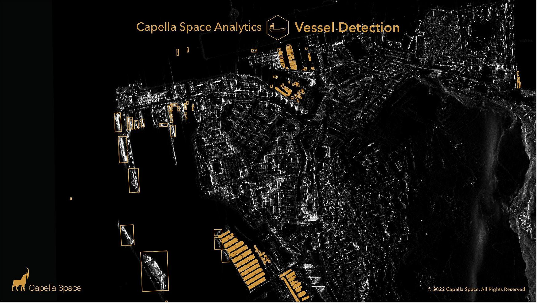
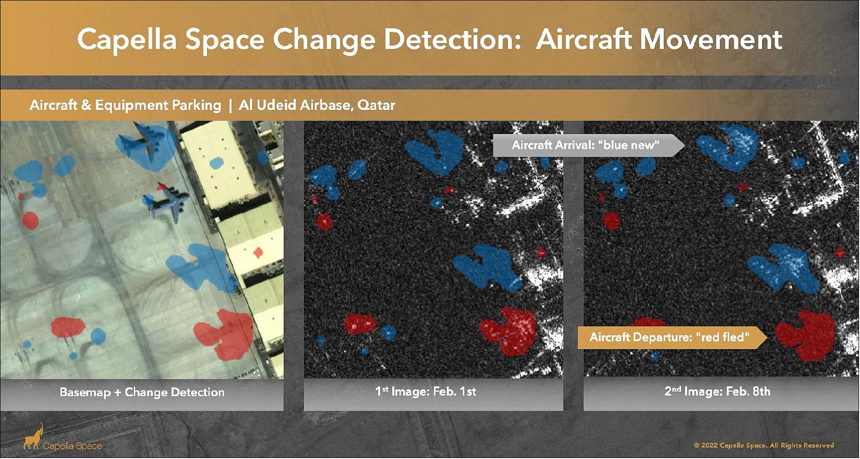
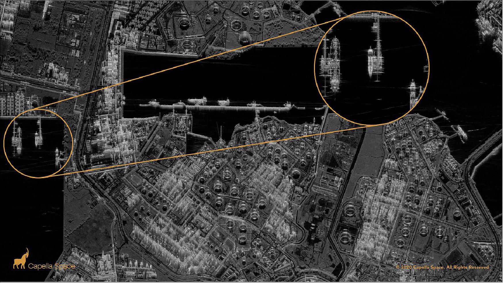
• April 14, 2022: Capella Space announced three new integrated analytics capabilities into its image-tasking web application, the Capella Console. Vessel Detection (which, by use of artificial intelligence, can identify and locate maritime vessels from satellite images), Change Detection (users can create automated monitoring campaigns that compare changes over time for an area of interest), and Global Change Monitoring (users have more access and more insight into all corners of the globe via the Global Change Monitoring product) support Capella's vision to offer a fully automated image tasking system that provides customers with timely, reliable, and accurate imagery capture and data analysis. 25) With these new products, Capella expands its services so government and commercial customers can not only task and collect high-resolution SAR imagery on demand, but also gain automated insights into what the imagery is showing.
• November 9, 2021: Capella Space announced the installation of optical communications terminals on SAR satellites by 2022 as part of a campaign to quickly deliver data to the Pentagon Space Development Agency’s (SDA) new National Defense Space Architecture, the company announced Nov. 9. 26) “Enabling our satellites to integrate with the new SDA architecture efficiently is a critical step for us to work seamlessly with the U.S. defense and intelligence sector. We are proud to be able to work with the SDA in demonstrating this cutting-edge technology.” Christian Lenz, Capella Space chief technology officer, said in a statement. Capella selected Mynaric’s CONDOR Mk3 Optical Communications Terminal to transmit data from its own satellites in low Earth orbit to government satellites and to military ground stations.
• October 21, 2021: Capella Space is working with the U.S. Army Space and Missile Defense Technical Center (SMDTC) to satisfy Army demand for Earth observation with rapid tasking and delivery of synthetic-aperture radar (SAR) data. 27) Under a Cooperative Research and Development Agreement (CRADA) announced Oct. 21, Capella and the U.S. Army Payload Development Lab are to explore applications for SAR through simulation and testing. Capella continues to establish relationships with the U.S. government agencies after last year’s contracts with the U.S. Navy, U.S. Air Force, U.S. Space Force, National Geospatial-Intelligence Agency and the Pentagon Space Development Agency. Government agencies around the world are key customers for SAR, which can peer through clouds and capture imagery day and night. In addition to the imagery, SAR data can reveal the material properties of objects as well as provide information on moisture, elevation and small changes in the position of objects. “The U.S. Government is still the largest customer of SAR data, but we are actively building a market for commercial applications that help companies and nongovernmental organizations make better economic decisions,” said Payam Banazadeh, Capella’s CEO.
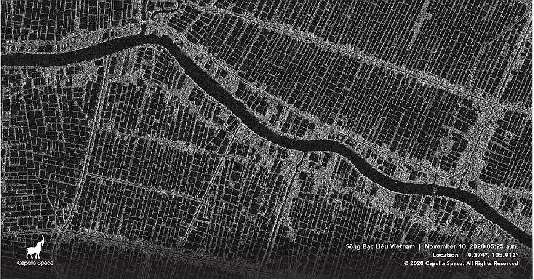
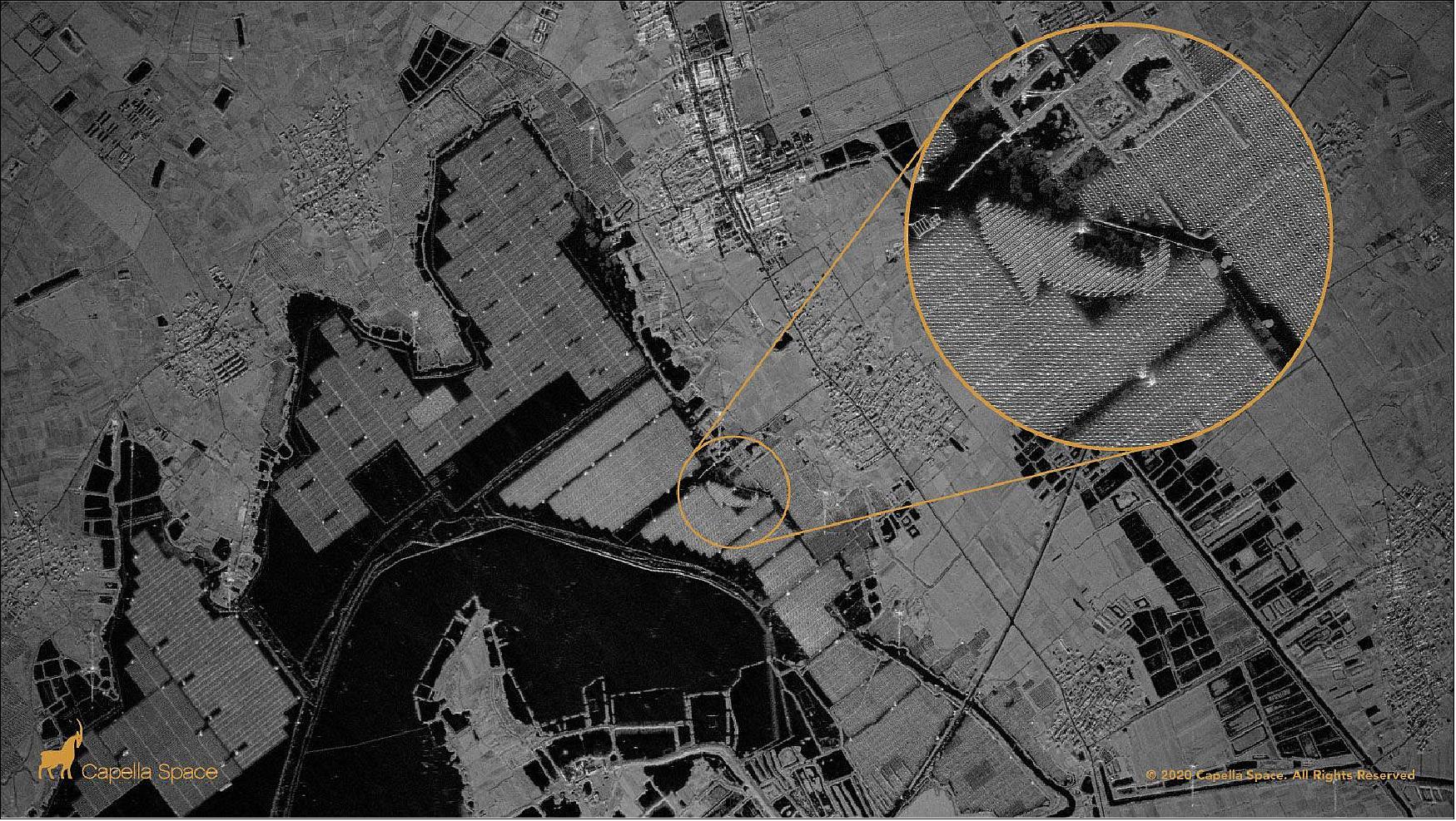
• September 14, 2021: Capella Space announced plans to share SAR data gathered by its satellite constellation with researchers, nonprofit organizations, application developers and disaster response organizations. 28) Users of Capella’s Open Data Program will gain access to updated and historical imagery and data from the Capella Console, San Francisco startup’s online platform. Open Data Program currently consists of 60 high-resolution SAR scenes of sites on every continent, showing agriculture and aquaculture, energy and natural resources, infrastructure, maritime, environmental, humanitarian disasters and natural disasters. Through the initiative, Capella intends “to foster innovation and discover the next game-changing applications of SAR” says Jason Brown, Capella community enablement engineer, wrote in a Sept. 14 blog post.
• June 17, 2021: Capella Space on June 14 received a $3 million research contract in support of the Space Development Agency’s National Defense Space Architecture. 29) Capella Space was selected through a “broad agency announcement” issued by the space agency in January seeking proposals on a wide range of technologies for “National Defense Space Architecture Systems, Technologies, and Emerging Capabilities.”
• June 9, 2021: Capella Releases Two New SAR Data Products: Geocoded Ellipsoid Corrected (GEC) and Sensor Independent Complex Data (SICD).
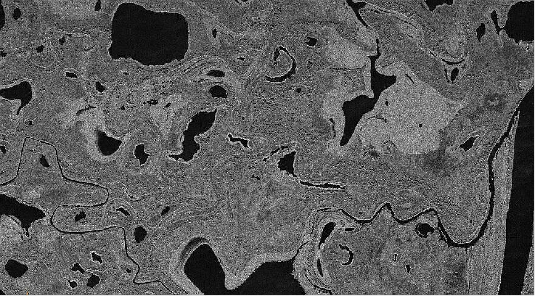
• May 28, 2021: Capella Space released the first light images from Capella-6, the latest satellite added to their SAR satellite constellation, launched just 5 days earlier on the SpaceX Starlink 28 mission. This is a breakthrough in the SAR industry, as the standard for imagery deliveries of an already orbiting satellite used to be of 5 days. In this same amount of time, Capella have launched, commissioned, and collected imagery. 30)
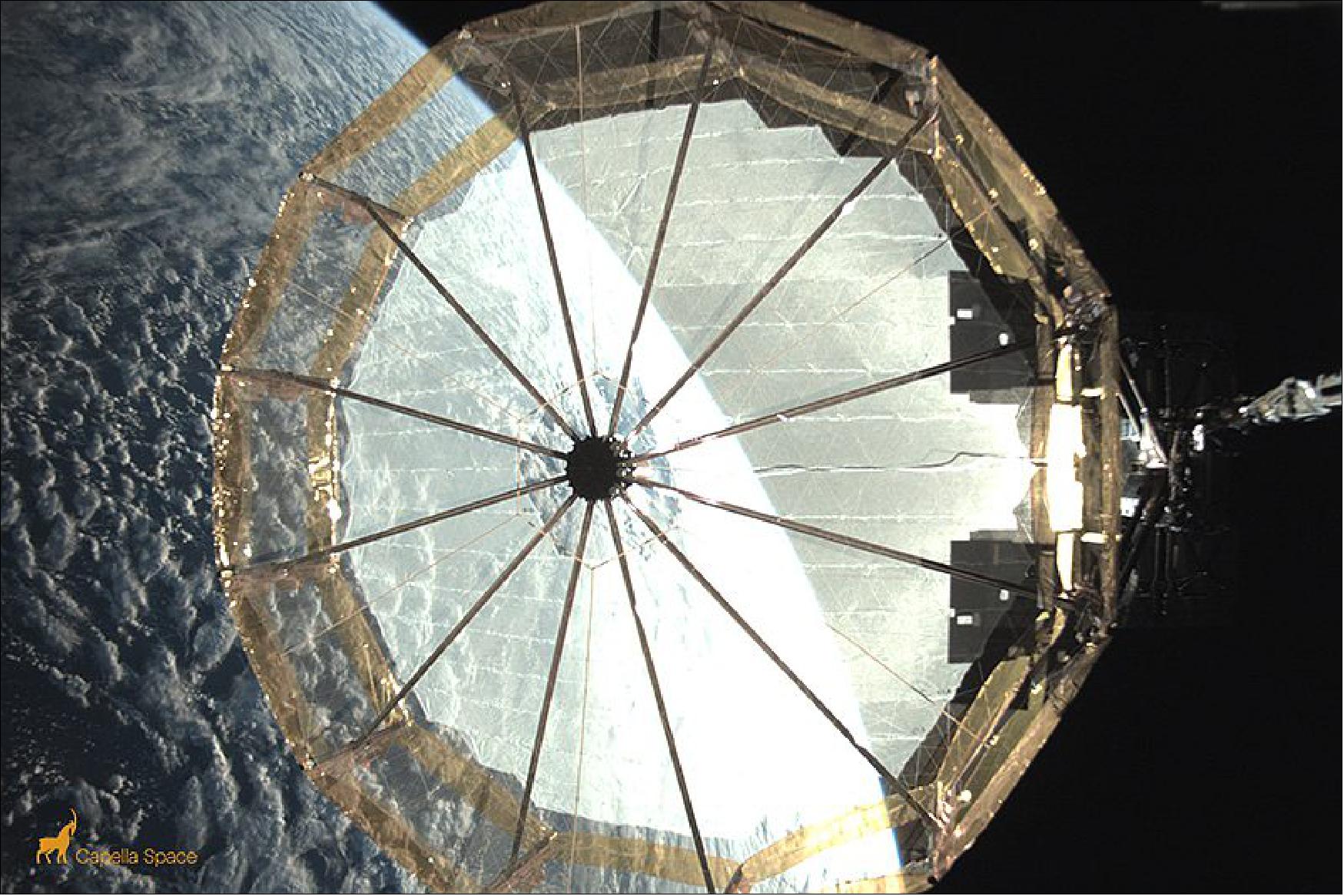
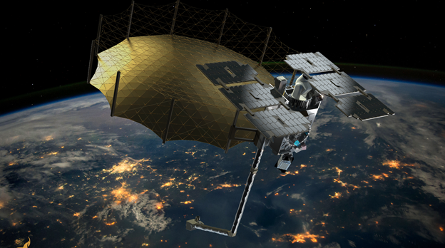
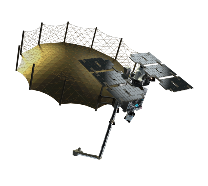
Figure 12: Reflector Antenna Deployment. Final deployment of the mesh-based reflector antenna. (image credit: Capella Space)
• April 14, 2021: Capella Space Accelerates 2021 Growth with New Chief Financial Officer and Expanded Leadership Team (Link
)
• March 12, 2021: Capella Space Welcomes Dan Getman, VP of Product (Link
)
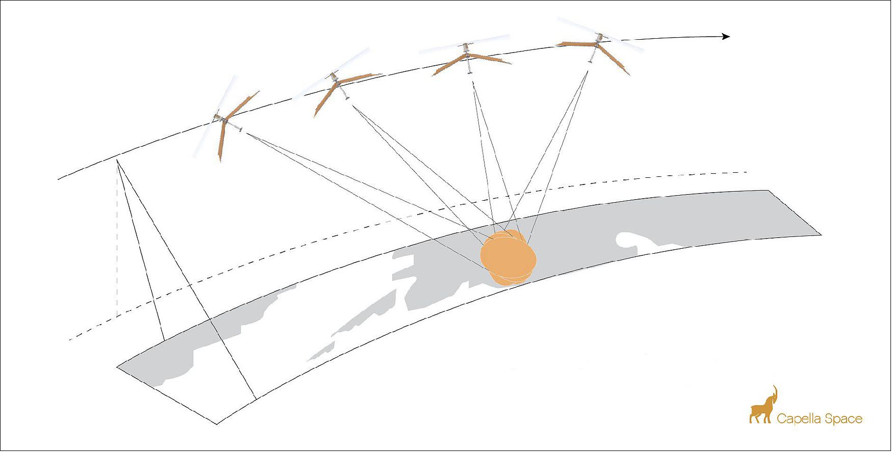
• December 16, 2020: Capella is the highest resolution commercial SAR provider in the world, capable of 50 cm x 50 cm resolution imaging with up to 500 MHz of bandwidth (which is announced to be improved to 1.2 GHz in the next generations). Prior to Capella, the best resolution on the market was 1 m x 25 cm, with non-square pixels which created its own challenges, and limited bandwidth of 300 MHz. Capella satellites could dwell on a single target for as long as 60 seconds, which far exceeds previous technology which could only dwell for a few seconds. Images of this resolution can be used to better track vegetation fires or to make disappearing planes a matter of the past. The high-resolution images are available to the customers through the Capella Console and API.
Capella’s Spot product is a specialized mode that allows for long exposures over an area of interest (AOI) and results in clear SAR imagery. This 50 cm x 50 cm imagery is collected by dwelling the satellites over an AOI for a long period.
• November 23, 2020: Fleet operator Inmarsat and communications technology firm Addvalue Innovation announced success relaying data between Capella Space’s operations center on the ground and Capella’s Sequoia SAR satellite in low Earth orbit. 32) For years, London-based Inmarsat and Addvalue Innovation, a subsidiary of Singapore-based Addvalue Technologies Ltd., have worked together to establish a commercial Intersatellite Data Relay System (IDRS) to continuously link satellites in low Earth orbit with ground networks. This has now become possible due to Capella’s SAR satellites. Capella Space conducted the first commercial demonstration of the IDRS service Nov. 12 when it sent tasking orders to Sequoia through the Inmarsat-4 L-band constellation in geostationary orbit. Inmarsat and Addvalue also expect IDRS technology to be adopted by customers gathering climate data and performing disaster relief missions because it allows operators to send commands to satellites without waiting for them to pass over ground stations. “This real-time connectivity will allow us to significantly reduce the time between customer tasking requests and when we collect the data on-orbit.” said Christian Lenz, Capella Space vice president of engineering.
• July 9, 2020: Capella Space has signed a Cooperative Research and Development Agreement (CRADA) with the National Geospatial-Intelligence Agency (NGA). The CRADA gives Capella access to NGA researchers for deeper insight into problems and in return NGA gains access to Capella Space’s SAR data and analytics services and signifies NGA’s first research partnership with an American commercial small satellite SAR data company, in an effort to expand its research capabilities. 35) . Capella will play a critical role in satisfying NGA’s mission to expand its production and publication of unclassified operations and intelligence. The CRADA further strengthens Capella Space’s already-trusted relationship with United States government agencies. This past May, Capella Space signed a contract with the Department of Defense to provide on-demand, high-resolution SAR data and analytics for the U.S. Navy.
• June 30, 2020: Capella Space runs its entire IT infrastructure on AWS to automate and scale its operations. Capella leverages AWS storage, database, machine learning, and analytics services to process the terabyte-size data collected daily by the satellites. The finessed data is immediately available upon downlink, helping its customers quickly gain insights for dynamic applications such as detecting illegal maritime activities and assessing the impact of natural disasters. Furthermore, Capella is developing a searchable archive of Earth observation data in the cloud, providing its customers with benchmark data so they can track subtle changes to the environment, discerning patterns over time to help them inform business and policy decisions.36)
• March 5, 2020: Capella Space and Rocket Lab to Launch Mid-Inclination Satellite to Enable Improved Monitoring of Key Global Regions (Link)
• January 21, 2020: Capella Space Unveils Advanced Satellite Design to Deliver High Resolution On-Demand Earth Observation Data (Link )
Capella's first testbed satellite Denali, as well as ground-based testing. Enhancements include:
- Advanced design delivering high contrast, low-noise, sub-0.5 meter imagery: A 3.5 meter deployed mesh-based reflector antenna combined with a high power RADAR enable key performance improvements including quality advances.
- Extended duty cycle: A deployed 400 W solar array increases on-orbit duty cycle to 10 minutes per orbit.
- Continuous imaging over long distance: Advanced thermal management systems allow continuous imaging of up to 4000 km long strip images.
- Highly agile platform: Enabled by large reaction wheels, the new satellite quickly adjusts pointing to collect images from diverse targets.
- Staring spotlight image mode: New mode further enhances image quality with the ability to collect the highest commercially available multi-look data.
- Enhanced data downlink rate: A high average data rate downlink of 1.2 Gbit/s supports the massive image collection rate and extended duty cycle, providing more data per orbit than any other commercial SAR system in its class.
- Real-time tasking: A highly secure encrypted two-way link with Inmarsat through an exclusive partnership with Addvalue provides real time tasking capability for the entire Capella constellation.
• December 16, 2019: Capella to Start Commercial Operations in 2020 with Launch of Seven Synthetic Aperture Radar Satellites (Link)
• September 3, 2019: Capella Space Partners with SpaceNet® to Expand Access to SAR Data (Link)
Capella joins the collaborative SpaceNet partnership alongside In-Q-Tel’s (IQT) CosmiQ Works, Maxar Technologies, Intel AI and Amazon Web Services(AWS). Capella’s addition to the partnership presents an exciting opportunity to expand SpaceNet’s existing geospatial open source research to a new data type, Synthetic Aperture Radar (SAR).
• August 5, 2019: Capella Space Partners with Addvalue and Inmarsat for Real-time Tasking (Link), a one-stop digital, wireless and broadband communications technology products innovator, for the use of its Inter-Satellite Data Relay System (IDRS™) via Inmarsat’s global L-band satellite communications network. The Inmarsat network provides satellite uplink and downlink services, which enable Capella to task any satellite in its constellation in any location in the world in real-time. Through its agreement with Addvalue, Capella will have a significant market lead as the only SAR (Synthetic Aperture Radar) provider with real-time tasking capability.
• June 3, 2019: Capella Space (having at that point over 50 employees and $50 million financing) launched the first small U.S. radar satellite in December 2018, whose purpose was to set the ground for the desired constellation of 36 synthetic aperture radar satellites. The main advantage of these satellites is that, unlike electro optical satellites which require light, radar satellites capture imagery during the day, at night and through clouds. Capella plans to launch Sequoia, its first operational satellite. Capella also is establishing its infrastructure to allow customers to downlink satellite data directly. 37)
• December 3, 2018: Capella Space Is First American Company to Send Advanced Commercial Radar Satellite to Space (Link)
• September 26, 2018: Capella Space Closes $19M Series B to Deliver Reliable Earth Observation Data on Demand(Link)• March 2018: NOAA awarded Capella a license to send two X-band SAR satellites into polar orbits between 450 to 600 km with an inclination of ~97.5º.
References
1) Gordon Farquharson, William Woods, Craig Stringham, Navneet Sankarambadi, Lucas Riggi, ”The Capella Synthetic Aperture Radar Constellation,” Proceedings of IGARSS (International Geoscience and Remote Sensing Symposium), Valencia, Spain, July 23-27, 2018
2) Debra Werner, ”Capella’s first satellite launching this fall,” Space News, 8 August 2018, URL: https://spacenews.com/capellas-first-satellite-launching-this-fall/
3) Craig Stringham, Gordon Farquharson, Davide Castelletti, Eric Quist, Lucas Riggi, Duncan Eddy, and Scott Soenen, ”The Capella X-band SAR constellation for rapid imaging,” Proceedings of the 39th annual IGARSS (International Geoscience and Remote Sensing Symposium) 2019, Yokohama, Japan, 28 July - 2 August 2019
4) Sandra Erwin, ”Capella Space wins research contract from U.S. Space Development Agency,” SpaceNews, 17 June 2021, URL: https://spacenews.com/capella-space-wins-research-contract-from-u-s-space-development-agency/
5) ”Capella Space And Rocket Lab To Launch Mid-Inclination Satellite To Enable Improved Monitoring of Key Global Regions,” Spacewatch, 5 March 2020, URL: https://spacewatch.global/2020/03/capella-space-and-rocket-lab-to-launch-mid-inclination-satellite-to-enable-improved-monitoring-of-key-global-regions/14) ”Spaceflight SSO-A: SmallSat Express Mission,” SpaceX, 3 December 2018, URL: https://web.archive.org/web/20181204085402/https://www.spacex.com/news/2018/12/03/spaceflight-sso-smallsat-express-mission
15) ”Capella Space Is First American Company to Send Advanced Commercial Radar Satellite to Space,” PR Newswire Press Release, 3 December 2018, URL: https://markets.businessinsider.com/news/stocks/capella-space-is-first-american-company-to-send-advanced-commercial-radar-satellite-to-space-1027777044
16) ”Spaceflight - Introducing SSO-A: The smallsat express,” Spaceflight, 3 December 2018, URL: http://spaceflight.com/sso-a/17) ”Statement from Spaceflight, the Mission Manager, Launches 64 Satellites on First Dedicated Rideshare Mission,” Satnews Daily, 4 December 2018, URL: http://www.satnews.com/story.php?number=270036615
18) ”I Can't Believe It's Not Optical,” Rocket Lab, 31 August 2020, URL: https://www.rocketlabusa.com/missions/completed-missions/i-cant-believe-its-not-optical/
19) Stephen Clark, ”SpaceX smashes record with launch of 143 small satellites,” Spaceflight Now, 24 January 2021, URL: https://spaceflightnow.com/2021/01/24/spacex-launches-record-setting-rideshare-mission-with-143-small-satellites/38) Krebs, Gunter D. “Capella 2, ..., 10 (Sequoia, Whitney)”. Gunter's Space Page.URL: https://space.skyrocket.de/doc_sdat/capella-2.htm
39) Jeff Foust, 16 March, 2023, “Electron launches two Capella Space radar satellites”. URL: https://spacenews.com/electron-launches-two-capella-space-radar-satellites/40) Wikipedia, “Capella Space”, URL: https://en.wikipedia.org/wiki/Capella_Space
41) Foust, Jeff, “Electron fails during Capella Space launch”, Space News, September 19, 2023, URL: https://spacenews.com/electron-fails-during-capella-space-launch/
42) Sat News, “Rocket Lab launches their 40th Electron mission + successfully flies a reused Rutherford engine”, August 23, 2023, URL: https://news.satnews.com/2023/08/23/rocket-lab-launches-their-40th-electron-mission-successfully-flies-a-reused-rutherford-engine/
43) Space.com, “Rocket Lab suffers anomaly during launch, Earth-observation satellite lost”, September 19, 2023, URL: https://www.space.com/rocket-lab-electron-launch-failure-september-2023
IEEE Explore "Capella Space" References
- 1. D. Castelletti et al., "Capella Space VHR SAR Constellation: Advanced Tasking Patterns and Future Capabilities," IGARSS 2022 - 2022 IEEE International Geoscience and Remote Sensing Symposium, Kuala Lumpur, Malaysia, 2022, pp. 4137-4140, doi: 10.1109/IGARSS46834.2022.9884458.Abstract: Capella's first commercial Synthetic Aperture Radar (SAR) satellite was launched in August 2020. After more than one year of successful operations, Capella plans a continuous growth of both number of satellites and satellite capabilities. New tasking patterns allow the collection of pairs and time series of very high resolution (VHR) SAR images. A novel repeat tasking request pattern will enable SAR applications such as change detection and the exploitation of interferometric SAR (InSAR) techniques. The combination of on-board GPUs and dedicated on-board processing algorithms will be used for rapid target detection and minimized satellite downlink. On-board processing, applicable in many quasi real-time operational scenarios, can also be used for tipping and cueing other satellites to immediately capture a high resolution imagery. Finally, Capella Space Open Data program started in 2021 with new images added each quarter. keywords: {Satellites;Image resolution;Time series analysis;Geoscience and remote sensing;Object detection;Real-time systems;Radar polarimetry;VHR Synthetic Aperture Radar;InSAR;Onboard Processing;Capella Space;Open Data},URL:Â https://ieeexplore.ieee.org/stamp/stamp.jsp?tp=&arnumber=9884458&isnumber=9883024
- G. Farquharson et al., "The New Capella Space Satellite Generation: Acadia," IGARSS 2023 - 2023 IEEE International Geoscience and Remote Sensing Symposium, Pasadena, CA, USA, 2023, pp. 1513-1516, doi: 10.1109/IGARSS52108.2023.10283030.Abstract: Capella Space is the first US commercial company to build, launch, and operate a constellation of synthetic aperture radar satellites capable of collecting very high resolution SAR imagery. All satellites in the constellation carry an X-band radar capable of acquiring imagery in spotlight, sliding spotlight, and stripmap modes. In 2023, Capella will launch the first of a new generation of satellites names Acadia. These satellites will provide high quality imagery and lay the platform for advanced SAR data products, such as interferometric SAR and bistatic imagery. keywords: {Satellites;Spaceborne radar;Time series analysis;Imaging;Radar imaging;Radar polarimetry;Marine vehicles;Capella Space;SAR},URL:Â https://ieeexplore.ieee.org/stamp/stamp.jsp?tp=&arnumber=10283030&isnumber=10281399
- D. P. de Almeida, B. Graics, R. A. J. Chagas, F. L. de Sousa and F. Mattiello-Francisco, "Towards Simulation of CubeSat Operational Scenarios under a Cyber-Physical Systems View," 2021 10th Latin-American Symposium on Dependable Computing (LADC), Florianópolis, Brazil, 2021, pp. 1-4, doi: 10.1109/LADC53747.2021.9672594.Abstract: In the development of academic CubeSat-based space missions, it is common to skip or rush many practices of the Systems Engineering Process due to time and cost constraints, which may lead to issues later on in the mission and failures. Mission concept analyses are often in these practices, including the analysis of the in-orbit behavior of the satellite with respects to power consumption and data generation. With the purpose of supporting these analyses, this article introduces a workflow based on a Cyber-Physical abstraction of CubeSat mission operation scenarios, which uses architectural models based on SysML Class Diagrams and automatic model transformation to support the simulation of these operational scenarios in an open source Model-Based System Engineering (MBSE) tool. These simulations can be used in mission concept analyses in Phase-0 studies to verify initial operations requirements and drive further design implementations. keywords: {Analytical models;Satellites;Codes;Power demand;Space missions;Cyber-physical systems;Software;CubeSat-based space mission;MBSE;code generation;simulation},URL: https://ieeexplore.ieee.org/stamp/stamp.jsp?tp=&arnumber=9672594&isnumber=9672552
- L. Carrer, D. Castelletti, R. Pozzobon, F. Sauro and L. Bruzzone, "Subsurface Cavities Characterization from X-Band VHR Spaceborne SAR Images," IGARSS 2022 - 2022 IEEE International Geoscience and Remote Sensing Symposium, Kuala Lumpur, Malaysia, 2022, pp. 1468-1471, doi: 10.1109/IGARSS46834.2022.9884672.Abstract: Cave systems are one of the last frontiers of human exploration on both Earth and other celestial bodies. In this context, lava tubes are natural subsurface tunnels, which are not visible from the surface, that are ubiquitous on Earth as well as on the Moon and Mars. Skylights are one of the surface evidences of the presence of such conduits in the form of overhanging collapses of the cave ceiling, making these cavities partially observable and potentially accessible. In this paper, we propose a method for imaging and characterizing subsurface structures by spaceborne VHR SAR imaging. We performed several acquisitions over different Earth locations by exploiting Capella's X-band VHR SAR imaging radars in spotlight mode. The obtained results show that the proposed methodology is able to characterize the main geometric parameters of the first section of a lava tube (e.g. width, height) in the surroundings of a skylight and it provides an indication of the actual subsurface accessibility. The proposed methodology has several important implications for exploration and could be applied to different type of cavities other than lava tubes. keywords: {Earth;Optical interferometry;Radar remote sensing;Spaceborne radar;Radar imaging;Optical imaging;Radar polarimetry;VHR SAR;Caves;Lava Tubes;Capella Space X-band SAR},URL:Â https://ieeexplore.ieee.org/stamp/stamp.jsp?tp=&arnumber=9884672&isnumber=9883024
- L. Carrer, D. Castelletti, R. Pozzobon, F. Sauro and L. Bruzzone, "Advances in The Characterization of Caves From Spaceborne X-Band VHR Sar Images," IGARSS 2023 - 2023 IEEE International Geoscience and Remote Sensing Symposium, Pasadena, CA, USA, 2023, pp. 1380-1383, doi: 10.1109/IGARSS52108.2023.10282480.Abstract: Circular sinkholes (i.e., pits) are depressions in the ground caused by the collapse of the surface layer. These type of features are commonly found on Earth and on other celestial bodies such as the Moon and Mars. Sinkholes may provide access to an underground cave system but it is very difficult to understand their accessibility and internal shape from optical images. In this paper, we propose a methodology for characterizing circular sinkholes by exploiting X-Band Very High Resolution (VHR) Spaceborne Synthetic Aperture Radar (SAR) images. The analysis of our experimental results show that a set of bright reflections in the radar image can be attributed to the response of the circular pit vertical walls and interior. Accordingly, it is possible to characterize the internal morphology of the pit. The results of this work have implications for planetary exploration as the proposed methodology can be applied for characterizing planetary pits. keywords: {Mars;Solid modeling;Three-dimensional displays;Spaceborne radar;Morphology;Lighting;Radar imaging;VHR SAR;Sinkholes;Lava Tubes;Capella Space X-band SAR},URL:Â https://ieeexplore.ieee.org/stamp/stamp.jsp?tp=&arnumber=10282480&isnumber=10281399
- E. Makas and A. R. Aslan, "Trends in SAR Satellite Design: From Tons of Mass to Hundreds of Kilograms in Designing SAR Satellite," 2023 10th International Conference on Recent Advances in Air and Space Technologies (RAST), Istanbul, Turkiye, 2023, pp. 1-5, doi: 10.1109/RAST57548.2023.10197877.Abstract: Synthetic aperture radar (SAR) satellites have been used for almost 50 years. Over the years there has been a dramatic reduction in the size and mass of space-borne systems as well as operational techniques. Typically, very high ground resolution imaging requires very large satellites of several tons, while constellation of affordable small satellites provide very high temporal resolution. The present paper reviews spaceborne SAR system design constraints and orbit types to point out the challenges of designing a micro SAR satellite and discusses some solutions to them. keywords: {Space vehicles;Satellites;Image resolution;Spaceborne radar;Space technology;Space missions;Market research;Micro SAR Satellite;SAR Systems;small satellite},URL:Â https://ieeexplore.ieee.org/stamp/stamp.jsp?tp=&arnumber=10197877&isnumber=10197652
- l. C. du Manoir Geoffroy, S. Shruthi, Z. Yan and M. Mingze, "Architecture and design definition processes: Return of experiment about complementary MBSE tools to model consistent architecture layers and to support design trade-offs through a set based concurrent engineering approach," 2019 International Symposium on Systems Engineering (ISSE), Edinburgh, UK, 2019, pp. 1-7, doi: 10.1109/ISSE46696.2019.8984581.Abstract: In today's world, one current market trend tends to satisfy customers every day with better and cheaper products. This never-ending challenging contest pushes suppliers hard to find innovative solutions in order to keep one piece of the cake. As architecture and design translate requirements to form, mastering efficiently those two definition processes is critical to be able to stay in the race. What challenges design offices are facing today? How to define solutions that can satisfy all the system stakeholders? Which one would be the best? Based on an industrial case study, the purpose of this paper is to show how an integrated team of systems engineers went through system architecture and design, supported by two complementary MBSE tools. keywords: {Architecture;Design;MBSE;Capella;Geeglee},URL:Â https://ieeexplore.ieee.org/stamp/stamp.jsp?tp=&arnumber=8984581&isnumber=8984263
- K. Mattingly and S. De, "Capella Space X-Band Synthetic Aperture Radar (Sar) Data Applied to Environmental and Humanitarian Use Cases in Earth Observation with A Focus on Urban Footprint Mapping," IGARSS 2022 - 2022 IEEE International Geoscience and Remote Sensing Symposium, Kuala Lumpur, Malaysia, 2022, pp. 7127-7130, doi: 10.1109/IGARSS46834.2022.9884439.Abstract: Small-sat systems are providing unprecedented access to remote sensing data and at a cost far lower than traditional spacecraft. This makes them appealing for a range of environmental and humanitarian monitoring applications previously thought unfeasible. In this paper we are demonstrating Capella Space's VHR X-band SAR, high-revisit satellite constellation applied to rice agriculture, glaciology, and a particular focus on urban mapping. keywords: {Space vehicles;Earth;Satellite constellations;Costs;Agriculture;Sensors;Synthetic aperture radar;VHR;SmallSat;X-Band;Remote Sensing;Earth Observation},URL:Â https://ieeexplore.ieee.org/stamp/stamp.jsp?tp=&arnumber=9884439&isnumber=9883024
- L. Carrer, D. Castelletti, R. Pozzobon, F. Sauro and L. Bruzzone, "A Novel Method for Hidden Natural Caves Characterization and Accessibility Assessment From Spaceborne VHR SAR Images," in IEEE Transactions on Geoscience and Remote Sensing, vol. 61, pp. 1-11, 2023, Art no. 4500111, doi: 10.1109/TGRS.2022.3222991. Abstract: Caves are one of the last frontiers of human exploration on Earth. They are very relevant scientific targets as they host significant biodiversity and unique geologic formations. The presence of underground passages accessible for human or robotic exploration are revealed by localized collapse of the near-surface ceiling of a cave system (skylight). Remote sensing systems are a valuable tool for skylights detection as these features are often located on very remote and often inaccessible regions of the Earth. However, with the available remote sensing techniques and data analysis methodologies, it is very difficult to determine whether a skylight is providing access to a cave continuation or it represents only a closed depression with no extensions. In this article we propose a methodology, based on very high-resolution (VHR) orbital synthetic aperture radar (SAR) imaging systems, to estimate both caves geometric characteristics and accessibility information in the proximity of a skylight. To test our methodology, we acquired radar data over different Earth’s location by exploiting the Capella Space X-band microsatellite radar constellation. The experimental results show that our methodology effectively determines the caves geometric characteristics and accessibility under a variety of surface conditions. We also detected several unknown and unexplored large cave systems located near Volcan Wolf and Ecuador, Isla Isabela, Galapagos. The presented work has relevant implications for the field of geological studies, ecology, and space exploration research since optical imaging shows the evidence of potential cave systems accessible from skylights on other planetary bodies such as Mars. keywords: {Radar;Spaceborne radar;Earth;Synthetic aperture radar;Radar imaging;Rocks;Vegetation mapping;Capella space;caves;lava tubes;planetary surfaces;very high-resolution (VHR) synthetic aperture radar (SAR)}, URL: https://ieeexplore.ieee.org/stamp/stamp.jsp?tp=&arnumber=9954195&isnumber=10006360
- S. K. R. Akarapu et al., "Development of a Nanosatellite System Modeling Architecture for EIRSAT-1," 2023 IEEE 9th International Conference on Space Mission Challenges for Information Technology (SMC-IT), Pasadena, CA, USA, 2023, pp. 123-125, doi: 10.1109/SMC-IT56444.2023.00022.Abstract: Over the last two decades, CubeSats which are nanosatellites with form factors based on units (U) of 10 x 10 x 10 cm3, have become more common in academia, enabling students to gain hands-on experience with satellite design, testing and deployment [15]. The use of Commercial-Off-TheShelf (COTS) components reduces development cost and time, making CubeSats an accessible and cost effective route to space. CubeSats are increasingly important for in-orbit demonstrations of new technologies. Further, their flexibility allows them to be configured for a wide range of science mission profiles, either as a standalone platform, as a communications relay for lunar and inter-planetary missions, such as NASA’s Mars Cube One (MarCO) satellites [14], or as a daughter spacecraft to study a near-Earth object such as LICIACube [2]. Several CubeSats for high energy astrophysics are currently in orbit and in development [9]. keywords: {Space vehicles;Mars;Costs;Space missions;Moon;Systems modeling;Orbits;MBSE;CubeSats;Systems Engineering;Verification and Validation;Satellite Communications},URL: https://ieeexplore.ieee.org/stamp/stamp.jsp?tp=&arnumber=10207481&isnumber=10207194
- D. Sternberg, K. Lo and J. Baker, "Night Sky Testing of the Lunar Flashlight Star Tracker," 2022 IEEE Aerospace Conference (AERO), Big Sky, MT, USA, 2022, pp. 1-13, doi: 10.1109/AERO53065.2022.9843416.Abstract: Lunar Flashlight (LF) is a 6U, 14 kg spacecraft being built by the NASA Jet Propulsion Laboratory (JPL). The mission will use IR laser technology to search for volatiles and surface water ice deposits in the permanently shadowed regions (PSR) of the moon in preparation for future human lunar exploration. The fine pointing provided by the Guidance, Navigation and Control (GNC) system is crucial for the spacecraft to successfully reach the moon, enter a lunar orbit, and acquire scientific data. At the center of the GNC system's ability to determine the spacecraft's attitude is a star tracker. The LF star tracker is a commercial-off-the-shelf (COTS) unit built into the integrated GNC system provided by Blue Canyon Technologies. Blue Canyon tested the star tracker in a lab environment for basic functionality and attitude estimation capabilities; upon delivery of the hardware to JPL, further testing with a real night sky was desired to determine expected in-flight operational characteristics. JPL maintains the Table Mountain Facility with its suite of ground telescopes, including a 0.6m telescope with an equatorial mount. This stable platform provided a highly accurate method of providing slews and attitude holds akin to what the spacecraft will perform in flight. Therefore, by analyzing the data from these representative night-sky ground tests performed in March, 2021, it is possible to acquire expected flight performance of the star tracker, particularly in regard to the ability of the star tracker to maintain lock on the starfield during planned maneuver types. This paper presents the various tests that have been performed to ensure that the LF star tracker will function as part of the overall GNC system and integrated spacecraft once launched. Test data is included for several key tests, and a path forward towards future integration and testing at the spacecraft level is described. keywords: {Space vehicles;Target tracking;Moon;Stars;Surface emitting lasers;Telescopes;Position measurement},URL:Â https://ieeexplore.ieee.org/stamp/stamp.jsp?tp=&arnumber=9843416&isnumber=9843194
- D. Castelletti, G. Farquharson, C. Stringham and D. Eddy, "Operational Readiness of the Capella Space SAR System," IGARSS 2020 - 2020 IEEE International Geoscience and Remote Sensing Symposium, Waikoloa, HI, USA, 2020, pp. 3571-3573, doi: 10.1109/IGARSS39084.2020.9323757.Abstract: We summarize the key elements of the operational readiness of Sequoia, the first commercially-operational satellite SAR system built and launched by Capella Space. We provide an overview the radar system, and the space operations and commissioning plan. Sample imagery collected with Capella radar hardware on an airborne platform is used to demonstrate the imaging capability of Sequoia. keywords: {Radar imaging;Spaceborne radar;Radar;Task analysis;Image resolution;Radar antennas;Synthetic aperture radar;Synthetic Aperture Radar},URL:Â https://ieeexplore.ieee.org/stamp/stamp.jsp?tp=&arnumber=9323757&isnumber=9323063
- D. Castelletti, G. Farquharson, C. Stringham, M. Duersch and D. Eddy, "Capella Space First Operational SAR Satellite," 2021 IEEE International Geoscience and Remote Sensing Symposium IGARSS, Brussels, Belgium, 2021, pp. 1483-1486, doi: 10.1109/IGARSS47720.2021.9554100.Abstract: Capella Space launched its first commercial Synthetic Aperture Radar (SAR) satellite in August 2020. After commissioning phase, Capella started commercial operations in January 2021, deploying a fully-functional SAR system that demonstrates three engineering milestones: an 8-m2 deployable reflector mounted on small and agile satellite; the capability to process and timely deliver 0.5 m resolution spotlight images with 9 looks; and an automated tasking and delivery system that simplifies the ordering of high-quality SAR imagery for expert and novice users. In this paper, we present results from the commissioning and calibration/validation operations. We also compare images collected with the variety of imaging modes that Capella systems can collect. keywords: {Image resolution;Spaceborne radar;Satellite broadcasting;Imaging;Intellectual property;Radar imaging;Radiometry;Synthetic Aperture Radar;Small Satellites;SAR Constellation},URL:Â https://ieeexplore.ieee.org/stamp/stamp.jsp?tp=&arnumber=9554100&isnumber=9553016
- K. Mattingly and S. De, "Computer Vision Techniques Applied to Capella Space VHR X-Band Synthetic Aperture Radar (SAR) Satellite Data to Track Movement: Use Cases Of Glacial Ice and Ships," IGARSS 2023 - 2023 IEEE International Geoscience and Remote Sensing Symposium, Pasadena, CA, USA, 2023, pp. 195-198, doi: 10.1109/IGARSS52108.2023.10281583.Abstract: Satellites are often used to observe, understand, and track movement at the earth’s surface. SAR is an especially powerful tool for such applications due to its persistent viewing capability; it operates day or night and penetrates clouds, smoke, and other particulate cover that can occlude the ground from other instruments, like optical. There are many known techniques specific to determining motion in SAR data. However, this paper will apply an optical flow open source package, like Particle Image Velocimetry (PIV), to determine motion in SAR data provided by Capella Space. Movement will be analyzed across target velocities by implementing this technique on subapertures from a single collection and across a time-series collection over a given Area of Interest (AOI). Sample use cases in this paper include large ice blocks moving through a glacial mélange and moving ships on open water. keywords: {Target tracking;Satellites;Radar tracking;Ice;Radar polarimetry;Velocity measurement;Reliability;VHR;SmallSat;SAR;X-Band;Remote Sensing;Earth Observation;PIV;Velocity Tracking;Sea Ice;Moving Ships},URL: https://ieeexplore.ieee.org/stamp/stamp.jsp?tp=&arnumber=10281583&isnumber=10281399
- P. Popien, O. D’Hondt, V. Sunkara and S. Chakrabarti, "Deep Learning Based Urban Flood Mapping From High Resolution Capella Space Sar Imagery," IGARSS 2023 - 2023 IEEE International Geoscience and Remote Sensing Symposium, Pasadena, CA, USA, 2023, pp. 1384-1387, doi: 10.1109/IGARSS52108.2023.10281768.Abstract: In this paper, we address the problem of flood detection in urban environments from single Capella Space X-Band High-Resolution Synthetic Aperture Radar (HR SAR) images. Our approach uses a Convolutional Neural Network (CNN) architecture and proposes two innovations to deal with a limited amount of training data and the burden of manual labeling. We introduce a two-stage labeling process utilizing threshold-based predictions to reduce the amount of manual interaction in the annotation process. Moreover, we use several auxiliary inputs to give more context to the CNN. We train our model on 28 flooded and non-flooded scenes and evaluate its performance on 4 out-of-sample test images. We show that our approach outperforms threshold-based segmentation in all test scenes. keywords: {Deep learning;Technological innovation;Image segmentation;Annotations;Training data;Manuals;Radar polarimetry;Flood Detection;SAR;Deep Learning;Semantic segmentation},URL: https://ieeexplore.ieee.org/stamp/stamp.jsp?tp=&arnumber=10281768&isnumber=10281399
- S. Kamni, Y. Ouhammou, A. Bertout and E. Grolleau, "Towards a Model-based Multi-Objective Optimization Approach For Safety-Critical Real-Time Systems," 2020 Design, Automation & Test in Europe Conference & Exhibition (DATE), Grenoble, France, 2020, pp. 634-637, doi: 10.23919/DATE48585.2020.9116388.Abstract: In safety-critical real-time systems domain, obtaining the appropriate operational model which meets the temporal (e.g. deadlines) and business (e.g. redundancy) requirements while being optimal in terms of several metrics is a primordial process in the design life-cycle. Recently, several researches have proposed to explore cross-domain trade-offs for a higher behaviour performance. Indeed, this process represents the first step in the deployment phase, which is very sensitive because it could be error-prone and time consuming.This paper is a work in progress proposing an approach aiming to help real-time system architects to take benefit from existing works, overcome their limits, and capitalize the efforts. Furthermore, the approach is based on the model-driven engineering paradigm and suggests to ease the usage of methods and tools thanks to repositories gathering them as a sort of a shared knowledge. keywords: {Real-time systems;Task analysis;Measurement;Optimization methods;Linear programming;Hardware;Critical real-time systems;model-driven Engineering;multi-objective optimization;functional-to-architectural mapping;real-time analysis tools},URL:Â https://ieeexplore.ieee.org/stamp/stamp.jsp?tp=&arnumber=9116388&isnumber=9116186
- L. Carrer, D. Castelletti, R. Pozzobon, F. Sauro and L. Bruzzone, "A Method for the Characterization of the Interior of Pits from Single Spaceborne SAR Images," in IEEE Geoscience and Remote Sensing Letters, doi: 10.1109/LGRS.2024.3383109. Abstract: Pits are depressions in the ground that occur due to the collapse of the surface layer. The characterization from orbit of their internal structure using optical images is challenging due to uncontrolled illumination geometry. In this paper, we propose a methodology for the characterization of pits’ interiors by exploiting Synthetic Aperture Radar (SAR) images. The methodology analyzes the amplitude and range of the radar echoes originating from the pit’s interior for determining its geometric characteristics through data inversion. The experimental results demonstrate that a set of bright reflections in the radar image can be attributed to the response of pits’ vertical walls and floor. By applying the proposed methodology and interpreting the radar reflections, we are able to derive a geometric characterization (e.g., depth) of a given pit. The retrieved geometric parameters from SAR data of a terrestrial pit denoted as Well of Barhout align well with the ground truth. The findings of this study have implications for both Earth observation and planetary exploration. keywords: {Reflection;Floors;Radar;Radar imaging;Spaceborne radar;Three-dimensional displays;Radar polarimetry;SAR;Pit;Planetary Surfaces;Capella Space},URL: https://ieeexplore.ieee.org/stamp/stamp.jsp?tp=&arnumber=10485432&isnumber=4357975
- M. Verhoef et al., "Digital Engineering Hub Pathfinder," 2021 ACM/IEEE International Conference on Model Driven Engineering Languages and Systems Companion (MODELS-C), Fukuoka, Japan, 2021, pp. 467-476, doi: 10.1109/MODELS-C53483.2021.00073.Abstract: We present an overview of an integrated model-based engineering environment to support space system definition and feasibility assessment using concurrent engineering techniques. We briefly introduce the information model that has been development over the last decade and, as our main contribution in this paper, show how domain specific tools can be practically integrated in order to improve the data exchange in support of highly iterative design evolutions. The different styles of interfaces are presented in the context of a few representative domain specific engineering tools. The way they can be used in a typical engineering setting is presented, and we conclude by placing the development of this pathfinder project in context of the on-going digitalization of the space systems engineering workflow in the European space sector. keywords: {Europe;Model driven engineering;Data models;Concurrent engineering;integrated model-based engineering environment;concurrent design},URL:Â https://ieeexplore.ieee.org/stamp/stamp.jsp?tp=&arnumber=9643759&isnumber=9643613
- L. Batista and O. Hammami, "Capella based system engineering modelling and multi-objective optimization of avionics systems," 2016 IEEE International Symposium on Systems Engineering (ISSE), Edinburgh, UK, 2016, pp. 1-8, doi: 10.1109/SysEng.2016.7753127.Abstract: Capella is a system engineering public domain tool which has been recently released by THALES. It is a model based systems engineering tool that implements the Architecture Analysis & Design Integrated Approach (ARCADIA) framework. This paper proposes a process specification, design and optimization of a distributed avionics system. Capella is used as a design tool for Distributed Integrated Modular Avionics (DIMA). The DIMA architecture has interesting power, weight and cost metrics which are highly demanded by aerospace industry. The main challenges faced by DIMA system architects are related to functions allocation and device physical allocation. This problem refers to the system functions translation into tasks and further hardware allocation. These problems are hard to solve manually due to the high number of functions in modern systems. The design and development of DIMA systems can be dramatically improved using optimization techniques. Moreover, allocation strategies based on different figure of merit can be evaluated at a smaller cost. In this paper we develop a simplified DIMA model using the Capella tool and the framework ARCADIA. The model is extended using viewpoints for specifying additional system constraints. Model parameters are extracted to specify a binary integer problem for the system allocation process automation. Different cost functions are evaluated for a simple study case. keywords: {Modeling;Computer architecture;Resource management;Optimization;Aerospace electronics;Unified modeling language;architecture;multi-objective optimization;system engineering;distributed integrated modular avionics},URL:Â https://ieeexplore.ieee.org/stamp/stamp.jsp?tp=&arnumber=7753127&isnumber=7753113
- R. Jordão, F. Bahrami, R. Chen and I. Sander, "A multi-view and programming language agnostic framework for model-driven engineering," 2022 Forum on Specification & Design Languages (FDL), Linz, Austria, 2022, pp. 1-8, doi: 10.1109/FDL56239.2022.9925666.Abstract: Model-driven engineering (MDE) addresses the complexity of modern-day embedded system design. Multiple MDE frameworks are often integrated into a design process to use each MDE framework’s state-of-the-art tools for increased productivity. However, this integration requires substantial development effort.In this paper, we propose an MDE framework based on a formalism of system graphs and trait hierarchies for programming-language-agnostic integration between tools within our frame-work and with tools of other MDE frameworks. Implementing our framework for each programming language is a one-time development effort.We evaluate our proposal in an MDE design process by developing a Java supporting library and an AMALTHEA connector. Then we perform an MDE industrial avionics case study with both. The evaluation shows that our framework facilitates the integration of different tools and the independent development of different system parts. Therefore, our framework is a reliable MDE framework that lowers the effort of integrating tools to benefit from their combined state-of-the-art. keywords: {Connectors;Java;Computer languages;System integration;Aerospace electronics;Solids;Model driven engineering;Model-driven Engineering;System Modelling;Collaborative Tools},URL: https://ieeexplore.ieee.org/stamp/stamp.jsp?tp=&arnumber=9925666&isnumber=9925654
FAQ
CEOS EO HANDBOOK – MISSION SUMMARY
- Capella X-SAR
-

|
|||||||||
| Full Name | Capella Space X-band Synthetic Aperture Radar | Status | Operational (nominal) | ||||||
| Mission Agencies |
Capella Space")
|
Launch Date | 03 Dec 2018 | ||||||
| Mission Links | mission site | EOL Date | Dec 2027 | ||||||
| EO Portal Info |
|
NORAD Catalog # | 57693 (TLE) | ||||||
|
|
International Designator | 2023-126A | |||||||
|
| |||||||||
| Orbit Type | Sun-synchronous | Orbit Period | 90 minutes | ||||||
| Orbit Sense |
|
Orbit Inclination | 90 deg | ||||||
| Orbit Altitude | 575 km | Orbit Longitude |
|
||||||
| Orbit LST |
|
Repeat Cycle | 0.25 days | ||||||
|
| |||||||||
| Objectives and Applications | Capella Space is a space technology company with data and satellite solutions for government and commercial use, delivering commercial SAR imagery. Capella provides access to information affecting industries worldwide, including defense and intelligence, supply chain, insurance, maritime and others. Its SAR satellites deliver global insights into commerce, conservation, and security on Earth. Capella is headquartered in San Francisco, California with additional locations in Denver, Colorado and Washington, D.C. | ||||||||
|
| |||||||||
| Mission Measurements |
|
||||||||
|
| |||||||||
| Mission Instruments |
|
||||||||
|
| |||||||||
| OpenSearch Datasets |
No IDN OpenSearch datasets found. No FedEO OpenSearch datasets found. Want to explore more? Read about FedEO  by ESA or click here to search FedEO or CMR OpenSearch by NASA by ESA or click here to search FedEO or CMR OpenSearch by NASA |
||||||||


No comments:
Post a Comment